

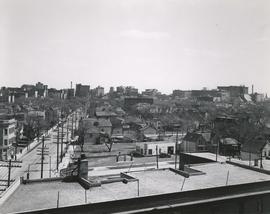
View of Main Street south from Higgins showing Alberta Hotel
- i01449
- Item
- [ca. 1930]
Date of photograph is uncertain, [before 1949].
747 results with digital objects Show results with digital objects
View of Main Street south from Higgins showing Alberta Hotel
Date of photograph is uncertain, [before 1949].

Floods - St. Boniface and Norwood - April 1916
Postcard is a photographic print showing water flooding homes. Photograph taken by Advance Photo Company, Winnipeg. Azo mark appears in stamp box, made in Canada.
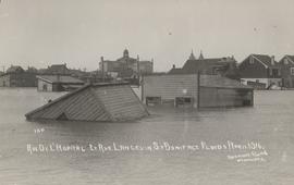
Rue De L'Hopital et Rue Langevin, St. Boniface Floods, April 1916
Postcard is a photographic print showing water flooding homes and other structures. Photograph taken by Advance Photo Company, Winnipeg. Azo mark appears in stamp box, made in Canada.

Rue Langevin, Floods, St. Boniface - April 1916
Postcard is a photographic print showing flood water and debris around buildings. Photograph taken by Advance Photo Company, Winnipeg. Azo mark appears in stamp box, made in Canada.

Winnipeg Boat Club under water, Norwood, April 1916
Postcard is a photographic print. Photograph taken by Advance Photo Company, Winnipeg. Azo mark appears in stamp box, made in Canada.
Postcard is a photographic print showing buildings surrounded by water. Unknown photographer, Noko mark appears in stamp box.

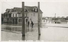
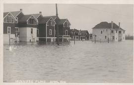
Winnipeg under water - April 1916
Postcard is a photographic print showing water flooding homes likely in St. Boniface. Unknown photographer, Noko mark appears in stamp box.
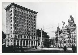
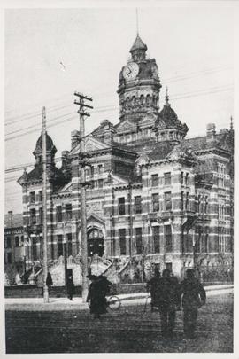
Winnipeg City Hall looking south west across Main Street at William Avenue
Photograph shows Winnipeg's second City Hall (1886-1962), Union Bank Building and Soldiers Monument (or Volunteer Monument). Date of photograph is uncertain, [before 1949].
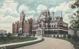
Winnipeg City Hall, Clock Tower
Photograph shows Winnipeg's second City Hall (1886-1962) with good view of clock tower. Date of photograph is uncertain, [before 1949].

Greek Tabernacle, Corner King and Stella Sts., Winnipeg
Postcard is a photographic print showing Greek Tabernacle "Tin Can Cathedral" at the corner of King Street and Stella Street. - Caption (on recto): This building is made of old tin cans pieces of metal fencins and [junk?] in general no new materials in it at all. - Inscription (on verso): from Mrs. O. Jacques [...] 1968.
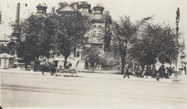
Winnipeg City Hall, Recruiting Stand
Photograph shows Winnipeg's second City Hall (1886-1962) with recruiting stand at lower left: 'Sign Up for Overseas. Volunteer Today, Tomorrow May be too Late.' - Likely taken shortly after the start of World War 1.
Postcard includes message from Tab to Beat? on verso. Published by C. S. Co. Ltd., Winnipeg, printed in Saxony.
Postcard shows Kennedy Street at York Ave., West Side. Photo by Notman. Published by Valentine & Sons' Publishing Co., Ltd., Montreal and Toronto. Date of postcard is uncertain, [before 1949].

Central Business District: Aerial view - Central Winnipeg
Date of photograph is approximate, ca. 1947.
View of Notre Dame Avenue looking east from Kate Street
Photograph shows Notre Dame Avenue looking east from Kate Street toward Lindsay Building at 228 Notre Dame Avenue. Businesses appearing in photograph include Green Orchard Lunch, 551 Notre Dame Avenue, and B - A Service Station. Date of photograph is approximate, ca. 1939.
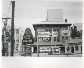
Existing Conditions, Corner of Graham and Donald looking East
A photograph of the southeast corner of Donald Street and Graham Avenue featuring a Moore's Taxi U Drive station in the foreground. Behind it in the background can be seen The Columbus Hall / Aragon Building with advertisements for Pepsi Cola and the Rainbow Dance Gardens, and the Tribune Building can be seen at the left. This is the present site of the Millennium Library. The back of the photo is marked: "Photograph 5. Existing Conditions, corner of Graham and Donald Looking East. Urban Renewal and Rehabilitation Board City of Winnipeg".
Winnipeg (Man.). Urban Renewal and Rehabilitation Board
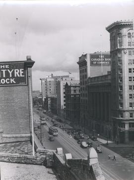
View of Main Street looking north from the Western Canada Loan Building
Photograph shows view of Main Street looking north from the roof of the Western Canada Loan Building, 392 Main Street at Portage Avenue. Date of photograph is approximate, ca. 1935.

Photograph shows old St. James Bridge approach, looking north up Madison Street (now Century Street/Route 90). Present Viscount Gort site in center. Date of photograph is uncertain, [after 1932].

Photograph shows old St. James Bridge approach, looking North up present Kintrye Street. Viscount Gort site centre right/Hydro sub-station - St. James Street and Portage Avenue far left. Date of photograph is uncertain [after 1932].