
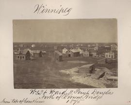
Winnipeg, West Ward, Point Douglas north of Browns Bridge, 1875
- i00035
- Item
- 1875
Part of City of Winnipeg (1874-1971)
Photograph taken from top of Courthouse.
13 results with digital objects Show results with digital objects
Winnipeg, West Ward, Point Douglas north of Browns Bridge, 1875
Part of City of Winnipeg (1874-1971)
Photograph taken from top of Courthouse.

Winnipeg, Main Street looking south, Summer 1875
Part of City of Winnipeg (1874-1971)
Photograph taken from top of Courthouse.

Winnipeg, Main Street looking south, Spring of 1874
Part of City of Winnipeg (1874-1971)
Photograph taken from top of Courthouse.
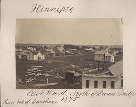
Winnipeg, East Ward, north of Browns Bridge, 1875
Part of City of Winnipeg (1874-1971)
Photograph taken from top of Courthouse.
Part of City of Winnipeg (1874-1971)
A photograph taken during the 1950 flood, showing Wellington by Maryland Bridge. Item is 1 of 8 photographs on page 90 of scrapbook.
Harold K. White Studio
Under construction, Oakwood Street
Part of City of Winnipeg (1874-1971)
A photograph taken during the 1950 flood, showing Oakwood Street under construction. Item is 1 of 7 photographs on page 25 of scrapbook.
Harold K. White Studio
S.W. Corner Arnold & Mabel (62?)
Part of City of Winnipeg (1874-1971)
A photograph taken during the 1950 flood, showing the southwest corner of Arnold Avenue and Mabel Avenue and possibly 62 Arnold Avenue. Item is 8 of 8 photographs on page 1 of scrapbook.
Harold K. White Studio
S.E. Corner Arnold Avenue (100 Arnold?)
Part of City of Winnipeg (1874-1971)
A photograph taken during the 1950 flood, showing the southeast corner of Arnold Avenue and possibly 100 Arnold Avenue. Item is 7 of 8 photographs on page 1 of scrapbook.
Harold K. White Studio
Scrapbook [1950 flood photographs]
Part of City of Winnipeg (1874-1971)
Subseries consists of a scrapbook assembled by the City Engineering Department to serve as photographic evidence of the 1950 flood. It contains black and white photographs that mostly document flooding in residential areas near the Red River (Fort Rouge, Riverview, North End, Point Douglas, Crescentwood, Armstrong's Point and others). Scrapbook appears to be organized geographically by area and street. In addition to documenting flooding, the photographs provide a detailed record of residential neighbourhoods, houses, streets, and businesses like corner grocery stores and laundries. All photographs were taken by Harold K. White Studio.
Winnipeg (Man.). City Engineer
Part of City of Winnipeg (1874-1971)
A photograph taken during the 1950 flood, showing "Scotia Block" on Scotia Street. Item is 2 of 8 photographs on page 46 of scrapbook.
Harold K. White Studio
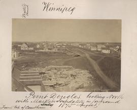
Point Douglas looking north with City Hall foundation in foreground, August 1875
Part of City of Winnipeg (1874-1971)
Photograph taken from top of Courthouse.

Point Douglas from Courthouse, 1874
Part of City of Winnipeg (1874-1971)

Part of East Ward, St. Boniface in the distance
Part of City of Winnipeg (1874-1971)
Photograph taken from top of Courthouse.
New house, 129, 133, 137, 143 and 145 Maplewood Avenue
Part of City of Winnipeg (1874-1971)
A photograph taken during the 1950 flood, showing 129 Maplewood Avenue and 133 Maplewood Avenue and 137 Maplewood Avenue and 143 Maplewood Avenue and 145 Maplewood Avenue. Item is 3 of 5 photographs on page 22 of scrapbook.
Harold K. White Studio
Negatives - 2 views ? Baltimore Road
Part of City of Winnipeg (1874-1971)
Negatives - 2 views ? Baltimore Road Item is 6 of 6 negatives on page 27 of scrapbook.
Harold K. White Studio
Part of City of Winnipeg (1874-1971)
A photograph taken during the 1950 flood, showing Morley Avenue Grocery located @ Morley and Fisher. Item is 2 of 8 photographs on page 11 of scrapbook.
Harold K. White Studio
Part of City of Winnipeg (1874-1971)
A photograph taken during the 1950 flood, showing Mayfair Apartments. Item is 2 of 5 photographs on page 86 of scrapbook.
Harold K. White Studio
Part of City of Winnipeg (1874-1971)
A photograph taken during the 1950 flood, showing Mabel Street. Item is 5 of 7 photographs on page 13 of scrapbook.
Harold K. White Studio
Part of City of Winnipeg (1874-1971)
A photograph taken during the 1950 flood, showing looking south on Westgate. Item is 1 of 2 photographs on page 107 of scrapbook.
Harold K. White Studio
Part of City of Winnipeg (1874-1971)
A photograph taken during the 1950 flood, showing looking south on Middlegate. Item is 1 of 2 photographs on page 102 of scrapbook.
Harold K. White Studio