
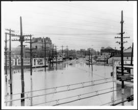
Main Street looking south from Main Street Bridge
- i00142
- Pièce
- 1950
Fait partie de City of Winnipeg (1874-1971)
A photograph of flooded Main Street, looking south from the Main Street Bridge, during the 1950 flood in Winnipeg.
Sans titre
Main Street looking south from Main Street Bridge
Fait partie de City of Winnipeg (1874-1971)
A photograph of flooded Main Street, looking south from the Main Street Bridge, during the 1950 flood in Winnipeg.
Sans titre

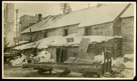
Fait partie de City of Winnipeg (1874-1971)
A photograph of floodwater and sandbag dikes outside 368 and 372 Main Street during the 1950 flood in Winnipeg.
Sans titre

Fait partie de City of Winnipeg (1874-1971)
A photograph of the intersection of Broadway and Osborne Street during the 1950 flood in Winnipeg. The photo is taken from Osborne Street, looking north; the stone cross of All Saints' Church can be seen near the left side of the image.
Sans titre
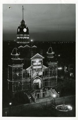
City Hall decorated for coronation
Fait partie de City of Winnipeg (1874-1971)
A photograph of City Hall decorated for the coronation of King George VI and Queen Elizabeth that took place on May 12, 1937. Sign reads, "LONG MAY THEY REIGN."
Sans titre
Fait partie de City of Winnipeg (1874-1971)
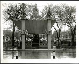
A photograph of a stage in front of City Hall, built for the visit to Winnipeg of Their Majesties King George VI and Queen Elizabeth on May 24, 1939.
Sans titre

Pumping water on Robert Street
Fait partie de City of Winnipeg (1874-1971)
A photograph of a pipe pouring water onto tracks on Robert Street (Galt Avenue) during the 1950 flood. A pile of wood is along one side of the street. The Ogilvie Flour Mill can be seen in the background.
Sans titre
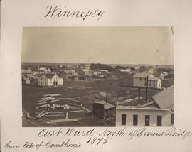
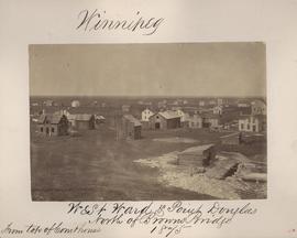
Winnipeg, East Ward, north of Browns Bridge, 1875
Fait partie de City of Winnipeg (1874-1971)
Photograph taken from top of Courthouse.

Winnipeg, Main Street looking south, Spring of 1874
Fait partie de City of Winnipeg (1874-1971)
Photograph taken from top of Courthouse.

Fait partie de City of Winnipeg (1874-1971)
Ox drawn cart shown in photograph.

Fait partie de City of Winnipeg (1874-1971)
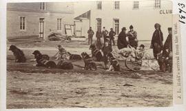
J. L. Reid's arrival from the west
Fait partie de City of Winnipeg (1874-1971)
Dog sled shown in photograph.

Winnipeg Fire Brigade, July 1, 1875
Fait partie de City of Winnipeg (1874-1971)

Part of East Ward, St. Boniface in the distance
Fait partie de City of Winnipeg (1874-1971)
Photograph taken from top of Courthouse.

Point Douglas from Courthouse, 1874
Fait partie de City of Winnipeg (1874-1971)

Winnipeg, Main Street looking south, Summer 1875
Fait partie de City of Winnipeg (1874-1971)
Photograph taken from top of Courthouse.
Winnipeg, West Ward, Point Douglas north of Browns Bridge, 1875
Fait partie de City of Winnipeg (1874-1971)
Photograph taken from top of Courthouse.
Telfer Block, 156 Lombard Avenue
Fait partie de City of Winnipeg (1874-1971)
Item is part of small album containing photographs of maps tracking the outbreak of typhoid from 1905 to 1908. Item is loose and at back of album. Date of item is approximate, [circa 1905].

Fait partie de City of Winnipeg (1874-1971)
Photograph of the Winnipeg Renovating Co. on Lombard Avenue. Item is part of small album containing photographs of maps tracking the outbreak of typhoid from 1905 to 1908 and other scenes. Item is loose and at back of album. Date of item is approximate, [circa 1909].

Fait partie de City of Winnipeg (1874-1971)
Photograph of the Winnipeg Renovating Co. and the Grain Exchange on Lombard Avenue. Item is part of small album containing photographs of maps tracking the outbreak of typhoid from 1905 to 1908 and other scenes. Item is loose and at back of album. Date of item is approximate, [circa 1909].

North side of Lombard, Rorie to Main Street
Fait partie de City of Winnipeg (1874-1971)
A photograph of storefronts and advertisements on the north side of Lombard Avenue, between Rorie Street and Main Street. The photograph is part of small album containing photographs of maps tracking the outbreak of typhoid from 1905 to 1909 and other scenes. Item is loose and at back of album.