

Winnipeg, Main Street looking south, Summer 1875
- i00033
- Pièce
- 1875
Fait partie de City of Winnipeg (1874-1971)
Photograph taken from top of Courthouse.
143 résultats avec objets numériques Afficher les résultats avec des objets numériques
Winnipeg, Main Street looking south, Summer 1875
Fait partie de City of Winnipeg (1874-1971)
Photograph taken from top of Courthouse.

Winnipeg, Main Street looking south, Spring of 1874
Fait partie de City of Winnipeg (1874-1971)
Photograph taken from top of Courthouse.

Main Street looking north from Portage Avenue
Fait partie de City of Winnipeg (1874-1971)
Bentley Building, Courthouse and Artesian well shown in photograph.

Fait partie de City of Winnipeg (1874-1971)
Photograph shows the North End Farmer's Market (west side Main Street, north of Stella Avenue, looking west to King Street). Included in photograph: front entrance to market, automobiles parked on street, and North End Horse Exchange (523 King Street). Photograph likely taken from 919-921 Main Street by city employee.

Fait partie de City of Winnipeg (1874-1971)
Photograph shows the North End Farmer's Market, looking east across Main Street (northwest Main Street and Stella Avenue). Included in photograph: stalls filled with vegetables and people walking through the market, Aime Bicycle Shop, 909 Main Street, two-storey brick building (899-905 Main Street), and Norquay School.

North side of Lombard, Rorie to Main Street
Fait partie de City of Winnipeg (1874-1971)
A photograph of storefronts and advertisements on the north side of Lombard Avenue, between Rorie Street and Main Street. The photograph is part of small album containing photographs of maps tracking the outbreak of typhoid from 1905 to 1909 and other scenes. Item is loose and at back of album.

Fait partie de City of Winnipeg (1874-1971)
Photograph of the Winnipeg Renovating Co. and the Grain Exchange on Lombard Avenue. Item is part of small album containing photographs of maps tracking the outbreak of typhoid from 1905 to 1908 and other scenes. Item is loose and at back of album. Date of item is approximate, [circa 1909].

Fait partie de City of Winnipeg Archives Photograph collection
Page shows five street views of Winnipeg, ca. 1903: 1) Main Street from Commercial Club, 2) Elgin Avenue, 3) Geo. Velie, Wholesale Wines and Liquors, 4) William Avenue, looking west, and 5) Main Street, looking north from Portage Avenue.

Crane and David, Bakers and Confectioners
Fait partie de City of Winnipeg Archives Photograph collection
Staff standing in front of Crane and David Bakers and Confectioners at 765 Dufferin Avenue and a horse-drawn delivery cart.
Fait partie de City of Winnipeg Archives Photograph collection
Photograph shows Dufferin Avenue, east of the Arlington Bridge, in background. Date of photograph is approximate, ca. 1936.
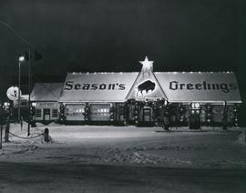
Prairies Cities Oil Service Station, Graham and Fort
Fait partie de City of Winnipeg Archives Photograph collection
Date of photograph is approximate, ca. 1937.
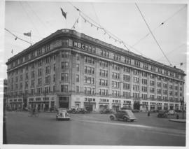
Hudson's Bay Company Store from Portage Avenue at Memorial Boulevard
Fait partie de City of Winnipeg Archives Photograph collection
Date of photograph is approximate, ca. 1942.

View of Main Street south from Higgins showing Alberta Hotel
Fait partie de City of Winnipeg Archives Photograph collection
Date of photograph is uncertain, [before 1949].
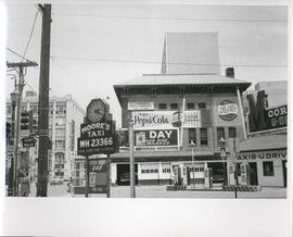
Existing Conditions, Corner of Graham and Donald looking East
Fait partie de City of Winnipeg Archives Photograph collection
A photograph of the southeast corner of Donald Street and Graham Avenue featuring a Moore's Taxi U Drive station in the foreground. Behind it in the background can be seen The Columbus Hall / Aragon Building with advertisements for Pepsi Cola and the Rainbow Dance Gardens, and the Tribune Building can be seen at the left. This is the present site of the Millennium Library. The back of the photo is marked: "Photograph 5. Existing Conditions, corner of Graham and Donald Looking East. Urban Renewal and Rehabilitation Board City of Winnipeg".
Sans titre
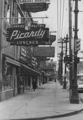
Overhanging Signs: North side of Portage Avenue looking East from Vaughan Street
Fait partie de City of Winnipeg Archives Photograph collection
Photograph shows signs for multiple businesses, including Picardy Lunches, Scientific Hairdressing, Credit Bureau. Date of photograph is uncertain, [196-?].

Overhanging Signs: North side of Portage Avenue looking West from Young Street
Fait partie de City of Winnipeg Archives Photograph collection
Photograph shows signs for multiple businesses, including Club Morocco, Riviera Restaurant, Princeton Café Fish and Chips, Portage Credit Jewellers. Date of photograph is uncertain, [196-?].

Overhanging Signs: North side of Portage Avenue looking East from Langside Street
Fait partie de City of Winnipeg Archives Photograph collection
Photograph shows signs for multiple businesses, including Club Morocco and Aqua-Terre Pet & Sporting Goods. Date of photograph is uncertain, [196-?].

Overhanging Signs: North side of Portage Avenue
Fait partie de City of Winnipeg Archives Photograph collection
Photograph shows sign for Club Morocco. Date of photograph is uncertain, [196-?].
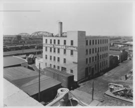
Fait partie de City of Winnipeg Archives Photograph collection
Date of photograph is uncertain, [before 1949].
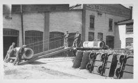
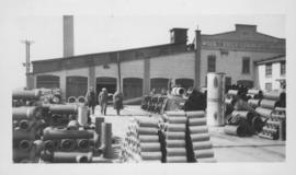
Men loading concrete forms onto truck
Fait partie de City of Winnipeg Archives Photograph collection
One of the men shown in photograph identified as Frank Richards. Wood's Brick Company Ltd. building visible in background. Date of photograph is uncertain, [before 1949].