
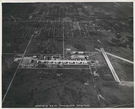
![Assiniboine to Airport, St. James [Aerial view]](/uploads/r/city-of-winnipeg-archives-amp-records-control-branch/c/9/8/c986dd715644d9b7d48854b59c8285d029a7db80cb4798af462d336b696964c9/C0013_0000_0000_P0018_0043_001_142.jpg)
Assiniboine to Airport, St. James [Aerial view]
- i01929
- Item
- 1945
Inscription (on recto): WG M35: 7-16, 5 Mar '45, Assiniboine to Airport, St. James, app scale 1/12000.
87 results with digital objects Show results with digital objects
Assiniboine to Airport, St. James [Aerial view]
Inscription (on recto): WG M35: 7-16, 5 Mar '45, Assiniboine to Airport, St. James, app scale 1/12000.
Aerial view of Stevenson Field looking South (Winnipeg Airport)
Inscription (on recto): 5A0S AP13 6-6-42 Stevenson Field looking South.

Aerial view of Stevenson Field (Winnipeg Airport)
Inscription (on recto): NE WG F24 AP117 45:55N 97.14W Stevenson Field 27-9-43 15:55 8" 6000'.

Photograph shows old St. James Bridge approach, looking North up present Kintrye Street. Viscount Gort site centre right/Hydro sub-station - St. James Street and Portage Avenue far left. Date of photograph is uncertain [after 1932].

Photograph shows old St. James Bridge approach, looking north up Madison Street (now Century Street/Route 90). Present Viscount Gort site in center. Date of photograph is uncertain, [after 1932].
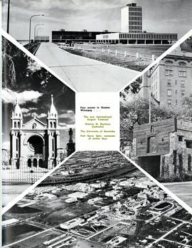
Four scenes in Greater Winnipeg
Photograph shows the then new International Airport Terminal, the St. Boniface Cathedral prior to the 1968 fire, the University of Manitoba and the Fort Garry Gate.
Metropolitan Corporation of Greater Winnipeg (Man.)