

Winnipeg, Main Street looking south, Summer 1875
- i00033
- Item
- 1875
Part of City of Winnipeg (1874-1971)
Photograph taken from top of Courthouse.
105 results with digital objects Show results with digital objects
Winnipeg, Main Street looking south, Summer 1875
Part of City of Winnipeg (1874-1971)
Photograph taken from top of Courthouse.

Winnipeg, Main Street looking south, Spring of 1874
Part of City of Winnipeg (1874-1971)
Photograph taken from top of Courthouse.

Main Street looking north from Portage Avenue
Part of City of Winnipeg (1874-1971)
Bentley Building, Courthouse and Artesian well shown in photograph.
Plans for the Club Building for the Columbus Hall Association
Part of City of Winnipeg (1874-1971)
11 pages of blueprint plans of the Club Building for the Columbus Hall Association Ltd. On the southwest corner of Graham Avenue and Smith Street. Designed by John D. Atchison.
Atchison, John D.
Plans for business premises of Mr. F.J. Sharpe, Portage Avenue
Part of City of Winnipeg (1874-1971)
2 pages of blueprints of the business premises of Mr. F.J. Sharpe on Portage Avenue. Designed by J.D. Atchison. Originally drawn on May 10, 1919, but revised on July 14, 1919.
Atchison, John D.
Plans for Garage for the McLaughlin Carriage Co., Maryland Street and Portage Avenue
Part of City of Winnipeg (1874-1971)
2 pages of blueprints of a Garage for the McLaughlin Carriage Co., at Maryland Street and Portage Avenue. Designed by J.D. Atchison.
Atchison, John D.
Plans for Medical Arts Building at the corner of Graham Avenue and Kennedy Street
Part of City of Winnipeg (1874-1971)
6 pages of blueprints of the Medical Arts Building at the corner of Graham Avenue and Kennedy Street.
Atchison, John D.
Plans for business premises for Mr. Nation, Portage Avenue
Part of City of Winnipeg (1874-1971)
3 pages of blueprints of the business premises of Mr. Nanton on Portage Avenue. Designed by J.D. Atchison.
Atchison, John D.
Plans for 383-389 Portage Avenue and 290 Edmonton Street (The Edmonton Block)
Part of City of Winnipeg (1874-1971)
6 pages of blueprint plans of stores on Portage Avenue and Edmonton Street, designed by John D. Atchison for W.H. Gardner. Includes 383-389 Portage Avenue and 290 Edmonton Street (the Edmonton Block)
Atchison, John D.

Part of City of Winnipeg (1874-1971)
Photograph shows the North End Farmer's Market (west side Main Street, north of Stella Avenue, looking west to King Street). Included in photograph: front entrance to market, automobiles parked on street, and North End Horse Exchange (523 King Street). Photograph likely taken from 919-921 Main Street by city employee.

Part of City of Winnipeg (1874-1971)
Photograph shows the North End Farmer's Market, looking east across Main Street (northwest Main Street and Stella Avenue). Included in photograph: stalls filled with vegetables and people walking through the market, Aime Bicycle Shop, 909 Main Street, two-storey brick building (899-905 Main Street), and Norquay School.

North side of Lombard, Rorie to Main Street
Part of City of Winnipeg (1874-1971)
A photograph of storefronts and advertisements on the north side of Lombard Avenue, between Rorie Street and Main Street. The photograph is part of small album containing photographs of maps tracking the outbreak of typhoid from 1905 to 1909 and other scenes. Item is loose and at back of album.

Part of City of Winnipeg (1874-1971)
Photograph of the Winnipeg Renovating Co. and the Grain Exchange on Lombard Avenue. Item is part of small album containing photographs of maps tracking the outbreak of typhoid from 1905 to 1908 and other scenes. Item is loose and at back of album. Date of item is approximate, [circa 1909].

Page shows five street views of Winnipeg, ca. 1903: 1) Main Street from Commercial Club, 2) Elgin Avenue, 3) Geo. Velie, Wholesale Wines and Liquors, 4) William Avenue, looking west, and 5) Main Street, looking north from Portage Avenue.

Crane and David, Bakers and Confectioners
Staff standing in front of Crane and David Bakers and Confectioners at 765 Dufferin Avenue and a horse-drawn delivery cart.
Photograph shows Dufferin Avenue, east of the Arlington Bridge, in background. Date of photograph is approximate, ca. 1936.
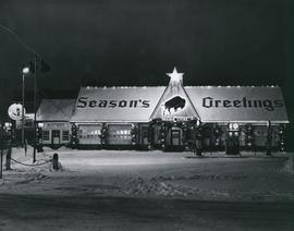
Prairies Cities Oil Service Station, Graham and Fort
Date of photograph is approximate, ca. 1937.
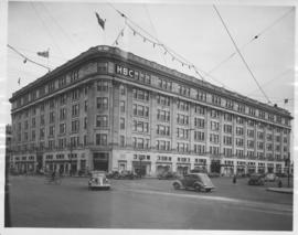
Hudson's Bay Company Store from Portage Avenue at Memorial Boulevard
Date of photograph is approximate, ca. 1942.

View of Main Street south from Higgins showing Alberta Hotel
Date of photograph is uncertain, [before 1949].
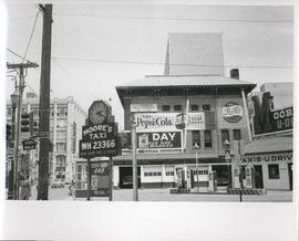
Existing Conditions, Corner of Graham and Donald looking East
A photograph of the southeast corner of Donald Street and Graham Avenue featuring a Moore's Taxi U Drive station in the foreground. Behind it in the background can be seen The Columbus Hall / Aragon Building with advertisements for Pepsi Cola and the Rainbow Dance Gardens, and the Tribune Building can be seen at the left. This is the present site of the Millennium Library. The back of the photo is marked: "Photograph 5. Existing Conditions, corner of Graham and Donald Looking East. Urban Renewal and Rehabilitation Board City of Winnipeg".
Winnipeg (Man.). Urban Renewal and Rehabilitation Board