
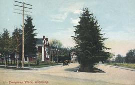
- i01462
- Pièce
- [194-?]
Fait partie de City of Winnipeg Archives Photograph collection
Postcard includes message from Tab to Beat? on verso. Published by C. S. Co. Ltd., Winnipeg, printed in Saxony.
Fait partie de City of Winnipeg Archives Photograph collection
Postcard includes message from Tab to Beat? on verso. Published by C. S. Co. Ltd., Winnipeg, printed in Saxony.
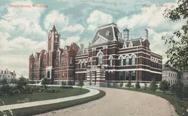
Fait partie de City of Winnipeg Archives Photograph collection
Postcard shows Kennedy Street at York Ave., West Side. Photo by Notman. Published by Valentine & Sons' Publishing Co., Ltd., Montreal and Toronto. Date of postcard is uncertain, [before 1949].

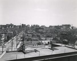
Central Business District: Aerial view - Central Winnipeg
Fait partie de City of Winnipeg Archives Photograph collection
Date of photograph is approximate, ca. 1947.
View of Notre Dame Avenue looking east from Kate Street
Fait partie de City of Winnipeg Archives Photograph collection
Photograph shows Notre Dame Avenue looking east from Kate Street toward Lindsay Building at 228 Notre Dame Avenue. Businesses appearing in photograph include Green Orchard Lunch, 551 Notre Dame Avenue, and B - A Service Station. Date of photograph is approximate, ca. 1939.
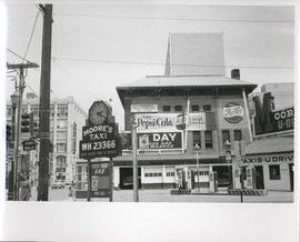
Existing Conditions, Corner of Graham and Donald looking East
Fait partie de City of Winnipeg Archives Photograph collection
A photograph of the southeast corner of Donald Street and Graham Avenue featuring a Moore's Taxi U Drive station in the foreground. Behind it in the background can be seen The Columbus Hall / Aragon Building with advertisements for Pepsi Cola and the Rainbow Dance Gardens, and the Tribune Building can be seen at the left. This is the present site of the Millennium Library. The back of the photo is marked: "Photograph 5. Existing Conditions, corner of Graham and Donald Looking East. Urban Renewal and Rehabilitation Board City of Winnipeg".
Sans titre
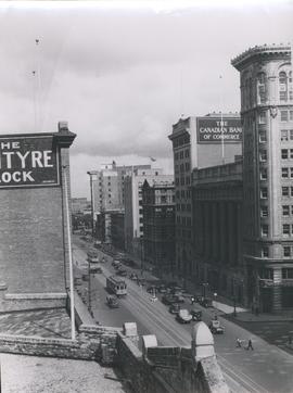
View of Main Street looking north from the Western Canada Loan Building
Fait partie de City of Winnipeg Archives Photograph collection
Photograph shows view of Main Street looking north from the roof of the Western Canada Loan Building, 392 Main Street at Portage Avenue. Date of photograph is approximate, ca. 1935.

Fait partie de City of Winnipeg Archives Photograph collection
Photograph shows old St. James Bridge approach, looking north up Madison Street (now Century Street/Route 90). Present Viscount Gort site in center. Date of photograph is uncertain, [after 1932].

Fait partie de City of Winnipeg Archives Photograph collection
Photograph shows old St. James Bridge approach, looking North up present Kintrye Street. Viscount Gort site centre right/Hydro sub-station - St. James Street and Portage Avenue far left. Date of photograph is uncertain [after 1932].
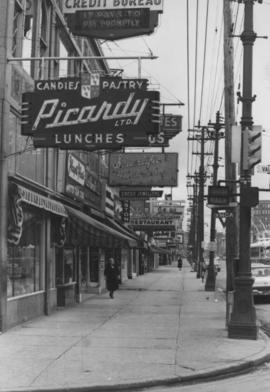
Overhanging Signs: North side of Portage Avenue looking East from Vaughan Street
Fait partie de City of Winnipeg Archives Photograph collection
Photograph shows signs for multiple businesses, including Picardy Lunches, Scientific Hairdressing, Credit Bureau. Date of photograph is uncertain, [196-?].

Overhanging Signs: North side of Portage Avenue looking West from Young Street
Fait partie de City of Winnipeg Archives Photograph collection
Photograph shows signs for multiple businesses, including Club Morocco, Riviera Restaurant, Princeton Café Fish and Chips, Portage Credit Jewellers. Date of photograph is uncertain, [196-?].

Overhanging Signs: North side of Portage Avenue looking East from Langside Street
Fait partie de City of Winnipeg Archives Photograph collection
Photograph shows signs for multiple businesses, including Club Morocco and Aqua-Terre Pet & Sporting Goods. Date of photograph is uncertain, [196-?].

Overhanging Signs: North side of Portage Avenue
Fait partie de City of Winnipeg Archives Photograph collection
Photograph shows sign for Club Morocco. Date of photograph is uncertain, [196-?].
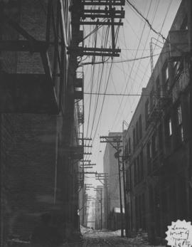
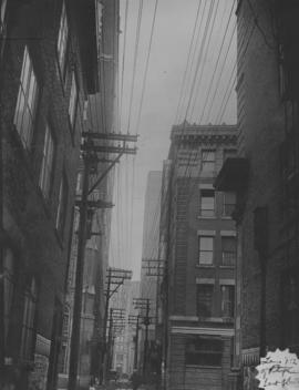
Lane west of Main, south of Portage, looking south from Portage
Fait partie de City of Winnipeg Archives Photograph collection
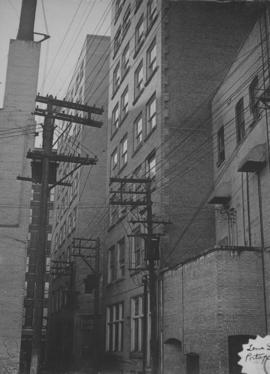
Lane north of Portage, between Donald and Smith, looking east
Fait partie de City of Winnipeg Archives Photograph collection

Fait partie de City of Winnipeg Archives Photograph collection
Item consists of a report cover for Downtown Winnipeg, created by the Metropolitan Corporation of Greater Winnipeg - Planning Division, April 1, 1969.
Sans titre

Downtown Winnipeg - Section and Interior View of Winter Garden
Fait partie de City of Winnipeg Archives Photograph collection
Items shows drawing in printed format that record plans for downtown area.
Sans titre
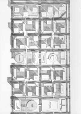
Downtown Winnipeg - Plan of St. Mary-Broadway Sector
Fait partie de City of Winnipeg Archives Photograph collection
Item shows drawing in printed format that records plans for downtown area.
Sans titre

Downtown Winnipeg - Model photo of Downtown Plan (side view)
Fait partie de City of Winnipeg Archives Photograph collection
Item appears to show photographic reproduction of model (side view) in printed format that records plans for downtown area.
Sans titre
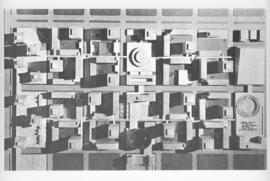
Downtown Winnipeg - Model Photo of Downtown Plan (aerial view)
Fait partie de City of Winnipeg Archives Photograph collection
Item appears to show photographic reproduction of model (aerial view) in printed format that records plans for downtown area.
Sans titre