

- i00042
- Item
- 1871
Part of City of Winnipeg (1874-1971)
Ox drawn cart shown in photograph.
351 results with digital objects Show results with digital objects
Part of City of Winnipeg (1874-1971)
Ox drawn cart shown in photograph.
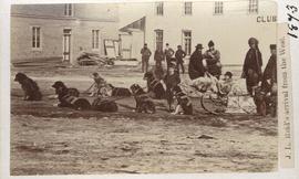
J. L. Reid's arrival from the west
Part of City of Winnipeg (1874-1971)
Dog sled shown in photograph.

Beginning of Causeway Sutherland at Disraeli
Part of City of Winnipeg (1874-1971)
A photograph of equipment and vehicles at the beginning of a rock causeway at the intersection of Sutherland Avenue and Disraeli Street during the 1950 flood.
Harold K. White Studio

Part of City of Winnipeg (1874-1971)
A photograph of flooding in a residential area of Winnipeg during the 1950 flood. The photograph was taken at the intersection of Disraeli and Euclid.
Harold K. White Studio

Part of City of Winnipeg (1874-1971)
A photograph of Higgins Avenue during the 1950 flood. A bridge over the swollen Red River can also be seen.
Harold K. White Studio

Part of City of Winnipeg (1874-1971)
A photograph of children on Higgins Avenue during the 1950 flood. Piles of earth and sandbags line the street.
Harold K. White Studio

Part of City of Winnipeg (1874-1971)
A photograph of a flooded underpass on Higgins Avenue during the 1950 flood.
Harold K. White Studio

Pumping water on Robert Street
Part of City of Winnipeg (1874-1971)
A photograph of a pipe pouring water onto tracks on Robert Street (Galt Avenue) during the 1950 flood. A pile of wood is along one side of the street. The Ogilvie Flour Mill can be seen in the background.
Harold K. White Studio

Foot of Robert Street (Galt Ave)
Part of City of Winnipeg (1874-1971)
A photograph of the Eaton's printing plant and warehouse on Robert Street (Galt Avenue) during the 1950 flood. The building is surrounded by a sandbag dike and water.
Harold K. White Studio
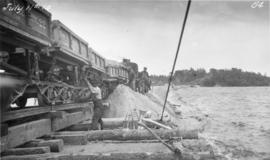
Placing material on Falcon River Diversion Dyke at Indian Bay
Photograph of workers using a scow to place material from cars onto the Falcon River Diversion Dyke at Indian Bay. Photograph taken by William G. Chace, Chief Engineer of the Winnipeg Aqueduct.
Greater Winnipeg Water District
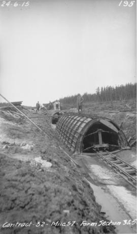
Winnipeg Aqueduct arch forms near Spruce Siding
Photograph of forms for arch sections three and five of the Winnipeg Aqueduct near Spruce Siding, Manitoba. Photograph taken by William G. Chace, Chief Engineer of the Winnipeg Aqueduct.
Greater Winnipeg Water District
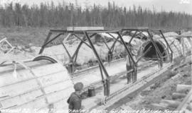
Device for moving aqueduct arch forms near Spruce Siding
Photograph of workers using a contractor's device for moving outside arch forms of the Winnipeg Aqueduct near Spruce Siding, Manitoba. Photographer is unknown.
Greater Winnipeg Water District
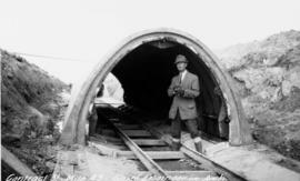
Chief Engineer Chace in aqueduct arch
Photograph of William G. Chace, Chief Engineer of the Winnipeg Aqueduct, standing in front of a completed aqueduct arch east of Brokenhead River. Photographer is unknown.
Greater Winnipeg Water District
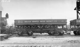
GWWD dump car at McCorkell Pit
Photograph of the side of a Greater Winnipeg Water District 20 cubic yard dump car at the McCorkell Pit, west of Ostenfeld, Manitoba. Photographer is unknown.
Greater Winnipeg Water District

Aqueduct siphon at Birch River crossing
Photograph of a Winnipeg Aqueduct siphon at the Birch River crossing near McMunn, Manitoba. Photographer is unknown.
Greater Winnipeg Water District
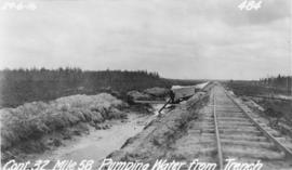
Pumping water from trench near Spruce Siding
Photograph of water being pumped from a trench next to the Greater Winnipeg Water District Railway near Spruce Siding, Manitoba, looking southeast. Photographer is unknown.
Greater Winnipeg Water District

Mixer site next to GWWD rail siding east of East Braintree
Photograph of a mixer site opposite Greater Winnipeg Water District siding rail line number 8, east of East Braintree, Manitoba. Photographer is unknown.
Greater Winnipeg Water District
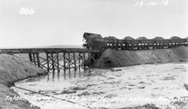
Filling in cofferdam for aqueduct's intake at Indian Bay
Photograph of dump cars filling in last gap of a cofferdam between dykes at the intake of the Winnipeg Aqueduct at Indian Bay, taken from the west dyke. Photographer is unknown.
Greater Winnipeg Water District

Clearing debris for aqueduct west of Snake Lake
Photograph of workers clearing debris between pole piling for the Winnipeg Aqueduct west of Snake Lake. Photographer is unknown.
Greater Winnipeg Water District
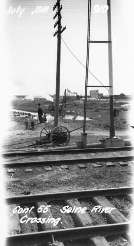
Photograph of the Seine River crossing of the Winnipeg Aqueduct, taken from the Canadian Northern Railway tracks north of Provencher Boulevard and looking northeast towards Rue Notre Dame. Photographer is unknown.
Greater Winnipeg Water District