

- i01421
- Item
- 1924
Photograph shows aerial view of downtown Winnipeg, looking north up Main Street from over Broadway and Main. Date of photograph is approximate, ca. 1924.
10 results with digital objects Show results with digital objects
Photograph shows aerial view of downtown Winnipeg, looking north up Main Street from over Broadway and Main. Date of photograph is approximate, ca. 1924.

Central Business District: Aerial view - Central Winnipeg
Date of photograph is approximate, ca. 1947.

Aerial view of intersection at Portage Avenue and Main Street
Photograph shows aerial view of intersection at Portage Avenue and Main Street (after barriers closing intersection to pedestrian concourse). Also shows Bank of Nova Scotia (Trizec Building) under construction. Photograph likely taken from the top of the Richardson Building.
Allan, Hugh
![Logan Avenue and Main Street [Aerial view]](/uploads/r/city-of-winnipeg-archives-amp-records-control-branch/d/9/2/d92728eee72f0ac3b14bbb8ea8f04c5d3ece08f19538ee5d078eb79492de602b/C0013_0000_0000_P0018_0034_001_142.jpg)
Logan Avenue and Main Street [Aerial view]
Inscription (on recto): A160 3-9-43 Logan Ave and Main St Wpg [Winnipeg] about 4000' 5".
![Kildonan Park [Aerial view]](/uploads/r/city-of-winnipeg-archives-amp-records-control-branch/f/5/8/f589f26a584950aadbe5b101158e69cde3cad16f0f0cf05dcbb2a97e34661f16/C0013_0000_0000_P0018_0037_001_142.jpg)
Inscription (on recto): WG M35: 2-18, 5 Mar. '45, Kildonan Park, Wpg [Winnipeg], appr. scale 1/12000.
![Vicinity of Elmwood Park [Aerial view]](/uploads/r/city-of-winnipeg-archives-amp-records-control-branch/5/b/9/5b929d618c2f619e557788462eee14587693511e7959bc6ca77ae96654d1bc98/C0013_0000_0000_P0018_0041_001_142.jpg)
Vicinity of Elmwood Park [Aerial view]
Inscription (on recto): WG M35: 3-15, 5 Mar '45, vicinity Elmwood Park Wpg, appr. scale 1/12000.
![Vicinity of Elmwood Park [Aerial view]](/uploads/r/city-of-winnipeg-archives-amp-records-control-branch/c/6/d/c6dc0bd0b8c2199f232fe8c7f5245d25e681a6a759be00e013a35a7a1ecada23/C0013_0000_0000_P0018_0042_001_142.jpg)
Vicinity of Elmwood Park [Aerial view]
Inscription (on recto): WG M35: 3-16, 5 Mar '45, vicinity Elmwood Park Wpg, appr scale 1/12000.
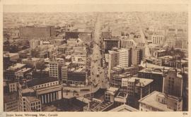
Street Scene, Winnipeg, Man., Canada
Item consists of a postcard in printed format that shows an aerial view of downtown Winnipeg, looking north up Main Street from Portage Avenue. Date of postcard is unknown.

Photograph shows an aerial view of the Red River north from the southern boundaries of North Kildonan and West St. Paul, north of Winnipeg. Photograph is dated December 2, 1943.

Aerial view of Point Douglas, St. Boniface, and Elmwood areas
Aerial photograph of Point Douglas, St. Boniface, and west Elmwood.