
- i00196
- Item
- 1950
Part of City of Winnipeg (1874-1971)
A photograph taken during the 1950 flood, showing 24 Arnold Avenue and 26 Arnold Avenue. Item is 4 of 8 photographs on page 1 of scrapbook.
Harold K. White Studio
355 results with digital objects Show results with digital objects
Part of City of Winnipeg (1874-1971)
A photograph taken during the 1950 flood, showing 24 Arnold Avenue and 26 Arnold Avenue. Item is 4 of 8 photographs on page 1 of scrapbook.
Harold K. White Studio
Part of City of Winnipeg (1874-1971)
A photograph taken during the 1950 flood, showing 20 Arnold Avenue. Item is 3 of 8 photographs on page 1 of scrapbook.
Harold K. White Studio
Part of City of Winnipeg (1874-1971)
A photograph taken during the 1950 flood, showing 14 Arnold Avenue. Item is 2 of 8 photographs on page 1 of scrapbook.
Harold K. White Studio
Part of City of Winnipeg (1874-1971)
A photograph taken during the 1950 flood, showing 8 Arnold Avenue. Item is 1 of 8 photographs on page 1 of scrapbook.
Harold K. White Studio

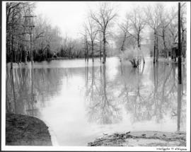
Part of City of Winnipeg (1874-1971)
A photograph of a flooded underpass on Portage Avenue during the 1950 flood in Winnipeg.
Harold K. White Studio
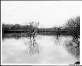
Part of City of Winnipeg (1874-1971)
A photograph of floodwater around the Maryland Bridge during the 1950 flood in Winnipeg.
Harold K. White Studio
Part of City of Winnipeg (1874-1971)
A photograph of flooding on West Gate during the 1950 flood in Winnipeg.
Harold K. White Studio

Part of City of Winnipeg (1874-1971)
A photograph of flooding at the corner of Wellington Crescent and Ash Street during the 1950 flood in Winnipeg.
Harold K. White Studio
Part of City of Winnipeg (1874-1971)
A photograph of flooding at the corner of Wellington Crescent and Niagara Street during the 1950 flood in Winnipeg.
Harold K. White Studio

Part of City of Winnipeg (1874-1971)
A photograph of flooded Assiniboine Avenue during the 1950 flood in Winnipeg.
Harold K. White Studio
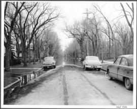
Part of City of Winnipeg (1874-1971)
A photograph of a flooded underpass on Pembina Highway during the 1950 flood in Winnipeg.
Harold K. White Studio

Part of City of Winnipeg (1874-1971)
A photograph of floodwater during the 1950 flood in Winnipeg. This photograph was taken looking north from the corner of Arnold Avenue and Hay Street; the Manitoba Legislature can be seen in the distance.
Harold K. White Studio
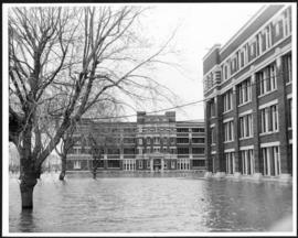
Part of City of Winnipeg (1874-1971)
A photograph of the Municipal Hospitals on Morley Street, surrounded by floodwater, during the 1950 flood in Winnipeg.
Harold K. White Studio
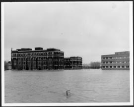
Part of City of Winnipeg (1874-1971)
A photograph of the Municipal Hospitals on Morley Street, surrounded by floodwater, during the 1950 flood in Winnipeg.
Harold K. White Studio
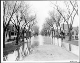
Part of City of Winnipeg (1874-1971)
A photograph of flooded Morley Avenue during the 1950 flood in Winnipeg.
Harold K. White Studio
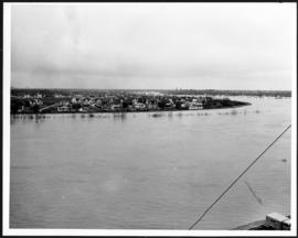
Lyndale Drive from Pellissier Br. Roof
Part of City of Winnipeg (1874-1971)
A photograph of Lyndale Drive, surrounded by high floodwater, during the 1950 flood in Winnipeg.
Harold K. White Studio
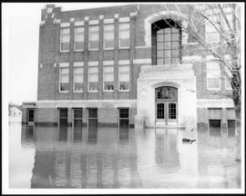
Part of City of Winnipeg (1874-1971)
A photograph of Riverview School, surrounded by floodwater, during the 1950 flood in Winnipeg.
Harold K. White Studio

Part of City of Winnipeg (1874-1971)
A photograph of people boating down Oakwood Avenue in the Riverview neighbourhood during the 1950 flood in Winnipeg.
Harold K. White Studio

Part of City of Winnipeg (1874-1971)
A photograph of floodwater being held back by a sandbag dike during the 1950 flood in Winnipeg.
Harold K. White Studio
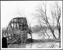
Part of City of Winnipeg (1874-1971)
A photograph of the Elm Park Bridge during the 1950 flood in Winnipeg.
Harold K. White Studio