
- i00854
- Item
- 1950
Part of City of Winnipeg (1874-1971)
A photograph taken during the 1950 flood, showing 9 Blanchard. Item is 2 of 2 photographs on page 111 of scrapbook.
Harold K. White Studio
212 results with digital objects Show results with digital objects
Part of City of Winnipeg (1874-1971)
A photograph taken during the 1950 flood, showing 9 Blanchard. Item is 2 of 2 photographs on page 111 of scrapbook.
Harold K. White Studio

Test Sections of aqueduct at Exhibition Grounds
Photograph of a test section of the Winnipeg Aqueduct at the Winnipeg Exhibition Grounds. Photograph faces west towards McPhillips Street and was taken by an unknown photographer.
Greater Winnipeg Water District

Aerial view looking south from over Wesley Park at rear of United College
Date of photograph is approximate, ca. 1937.
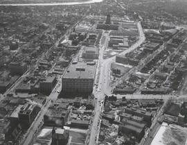
Aerial view of Winnipeg looking south on Memorial Boulevard toward Legislative Building
Date of photograph is approximate, ca. 1935.

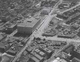
Central Business District: Aerial view - Central Winnipeg
Date of photograph is approximate, ca. 1947.
#2, P.R.M., Westminster and Canora - 1947

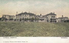
Winnipeg General Hospital and Alexandra Park
Postcard shows Winnipeg General Hospital in background, Bannatyne Avenue looking South across Alexandra Park. In foreground, Alexandra Park appears. Shows 1884 and 1897 buildings. Date of postcard is approximate, ca. 1897.
![Northwest Winnipeg [Aerial view]](/uploads/r/city-of-winnipeg-archives-amp-records-control-branch/4/f/3/4f37bff68f08b53a6e7296217f26c266711570595702620b7b89d115744d09e4/C0013_0000_0000_P0018_0025_001_142.jpg)
Northwest Winnipeg [Aerial view]
Aerial view of the Minto area. Inscription (on recto): WG A90 '41, 1941 - Northwest Winnipeg.
![Central Winnipeg between Portage and Notre Dame Avenues [Aerial view]](/uploads/r/city-of-winnipeg-archives-amp-records-control-branch/e/3/f/e3f90f80ff2b9d7dc2938509d7f4a5b4dfdfef9308ecfc0cfa38d5f1e2aa0bb8/C0013_0000_0000_P0018_0026_001_142.jpg)
Central Winnipeg between Portage and Notre Dame Avenues [Aerial view]
Inscription (on recto): WG A158 8/6/1942 Central Wpg between Portage and Notre Dame Ave's.
![C.P.R. Yards looking West [Aerial view]](/uploads/r/city-of-winnipeg-archives-amp-records-control-branch/1/d/2/1d24b0471a50903dd76276838a7e169e4890a17020a9cfe6a0d34e153ebb9ec9/C0013_0000_0000_P0018_0027_001_142.jpg)
C.P.R. Yards looking West [Aerial view]
Inscription (on recto): WG A114 30-2-42 CPR [Canadian Pacific Railway] RR [Railroad] Yards looking West.
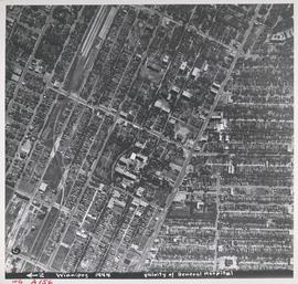
Aerial view of Vicinity of General Hospital, 1944
Description (on recto): WG A156, vicinity of General Hospital, Winnipeg, 1944. - Area around William Avenue and Sherbrook Street shown in photograph. - Photo credit: Royal Canadian Air Force Photograph.
![Logan Avenue and Salter Street [Aerial view]](/uploads/r/city-of-winnipeg-archives-amp-records-control-branch/9/8/0/980f8ba4214d821c9b49366ae35d9ea9ed5b7f44366c5cd894e04befdd6c7a22/C0013_0000_0000_P0018_0033_001_142.jpg)
Logan Avenue and Salter Street [Aerial view]
Inscription (on recto): A161 3-9-43 Logan Ave and Salter St Wp [Winnipeg?] about 4000' 5".

Aerial view of RCAF Equipment Depot Number 2
Aerial photograph showing the Royal Canadian Air Force Equipment Depot Number 2, south of Brooklands and Weston. The Weston Shops are featured at the top of the photograph. The Inscription (on recto): NE. WG. F24 AP144 49.55N 97.07W #7 Equip. Depot Wpg [Winnipeg], 14-3-44, 15:00, 8" 2500'.
![Sargent Park vicinity [Aerial view]](/uploads/r/city-of-winnipeg-archives-amp-records-control-branch/6/d/b/6dbefceeef372f0514de159e1569f5aba581dc63a4d454200688557662b9ce22/C0013_0000_0000_P0018_0038_001_142.jpg)
Sargent Park vicinity [Aerial view]
Inscription (on recto): WG M35: 5-9, 5 Mar. '45, Sgt Park Vicinity, appr. scale 1/12000.
![Sargent Park [Aerial View]](/uploads/r/city-of-winnipeg-archives-amp-records-control-branch/e/5/1/e51b6ff83bb626c524f2415a4d84c08187de0f175c746cbde40dcf11e700b8eb/C0013_0000_0000_P0018_0039_001_142.jpg)
Inscription (on recto): WG. M35: 5-10, 5 Mar' 45, Sgt Park Vicinity, appr. scale 1/12000.
![Legislative Building and Central Winnipeg [Aerial view]](/uploads/r/city-of-winnipeg-archives-amp-records-control-branch/5/1/1/511af88a9e92fe7d7d3edda2bdaee6fc5652013532efb88411d3403dfcf85917/C0013_0000_0000_P0018_0046_001_142.jpg)
Legislative Building and Central Winnipeg [Aerial view]
Inscription (on recto): WG M35: 4-5, 5 Mar '45, Legislative Bldg and Central Wpg, appr. scale 1/12000.
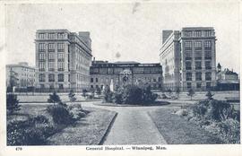
General Hospital - Winnipeg, Man.
Item consists of a postcard in printed format that shows the Winnipeg General Hospital. Date of postcard is unknown.

A military funeral, Broadway and Spence Streets, Winnipeg - 1914
Photograph taken at time of World War 1.