
- i01432
- Item
- 1925
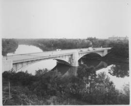
Photograph shows Maryland Street Bridge looking southeast into Crescentwood. Date of photograph is approximate, ca. 1925.
33 results directly related Exclude narrower terms
Photograph shows Maryland Street Bridge looking southeast into Crescentwood. Date of photograph is approximate, ca. 1925.

Winnipeg’s Best Tourist Cabin Camp on Pembina Highway
Postcard featuring “Winnipeg’s Best Tourist Cabin Camp”, located on Pembina Highway (then Highway Number 14) around Chevrier Boulevard.

Winnipeg Tourist Cabins and Camp Park on Pembina Highway
Postcard featuring “Winnipeg Tourist Cabins and Camp Park”, located on Pembina Highway (then Highway Number 14) around Chevrier Boulevard.
Part of City of Winnipeg (1874-1971)
Consists of correspondence, invitations, and souvenir programmes related to the 1926 meeting of the Brotherhood of Locomotive Engineers.
Winnipeg (Man.). Committee on Legislation and Reception
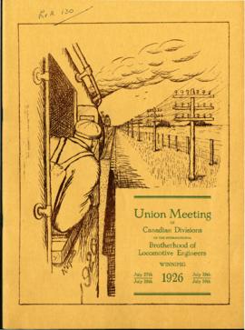
Souvenir Programme of Brotherhood of Locomotive Engineers meeting
Part of City of Winnipeg (1874-1971)
A promotional souvenir programme of the 1926 union meeting of the Canadian Divisions of the International Brotherhood of Locomotive Engineers, held in Winnipeg on July 27-30, 1926. Booklet contains promotional information about and histories of the union, photographs of and statements made by union members and local politicians, and advertisements.
Winnipeg (Man.). Committee on Legislation and Reception
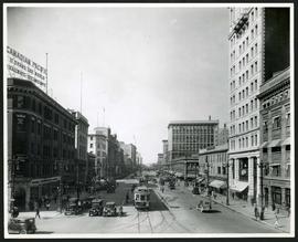
Portage Avenue looking west from Main Street
Date of photograph is approximate, ca. 1927.
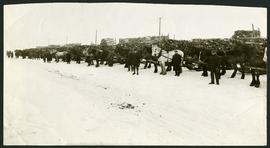
Unloading of relief wood at Greater Winnipeg Water District Station
Men at the Greater Winnipeg Water District station in St. Boniface standing in front of horses hauling wood piles for relief work. Photograph taken by Robinson Studio.
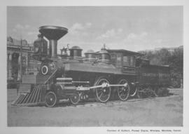
Countess of Dufferin, Pioneer Engine, Winnipeg, Manitoba
Print of a photographic image of the pioneer train engine Countess of Dufferin. Date of print is uncertain, [193-?].
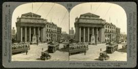
Bank of Montreal building, Portage and Main
Part of Morris Block collection
A promotional stereogram showing traffic and streetcars in front of the Bank of Montreal building at Portage Avenue and Main Street, made by the Keystone View Company. The reverse side of the image contains information about Winnipeg.
Block, Morris

Photograph shows old St. James Bridge approach, looking north up Madison Street (now Century Street/Route 90). Present Viscount Gort site in center. Date of photograph is uncertain, [after 1932].

1932 Relief Works and Committee Winnipeg
Photograph collage of the 1932 Winnipeg Relief Works and Committee. Portraits of committee members are surrounding photographs of projects the committee had worked on. The committee members are, clockwise from top left: Alderman John Blumberg, Alderman H. Andrews, City Clerk Magnus Peterson, Alderman J.A. Barry, Alderman A.A. Ryley, Alderman W.B. Simpson, City Engineer W.P. Brereton, G.W. Northwood, Alderman E.D. Honeyman, Mayor Ralph Webb, Alderman J.A. McKerschar, A. MacNamara, Resident Engineer A.J. Taunton, Alderman L.F. Borrowman, and Alderman C.E. Simonite. The works projects showcased in the center are, clockwise from top left: the Main Street Bridge, the Norwood Bridge, the Assiniboine Park Bridge, the Winnipeg Auditorium, the Sargent Park Swimming Pool, and the Salter Street Bridge. Created by Robson Photo.
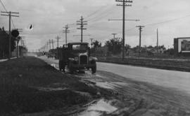
Main Street, corner Seven Oaks, Rainfall, June 29, 1932
Photograph is dated July 1, 1932.
Main Street - Perth to Hartford, Rainfall, June 29, 1932
Photograph is dated July 1, 1932.
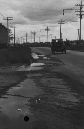
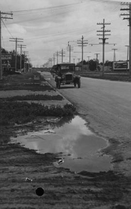
Main Street - Hartford to Belmont, 48 hours after rain
Date of photograph is July 1, 1932.

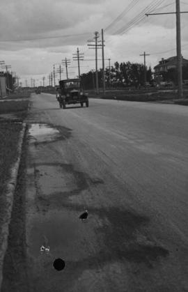
Main Street, south of Seven Oaks, 48 hours after rain
Date of photograph is July 8, 1932.

Photograph shows old St. James Bridge approach, looking North up present Kintrye Street. Viscount Gort site centre right/Hydro sub-station - St. James Street and Portage Avenue far left. Date of photograph is uncertain [after 1932].

For Your Guidance While in Winnipeg promotional map
Part of Morris Block collection
A promotional map created by the Publicity Bureau of Winnipeg and Manitoba titled "For Your Guidance While in Winnipeg". Map was originally folded as a pamphlet, the front page of which features a graphic of two people driving down Highway 14 (now Highway 75) to Winnipeg. The map is not scale and features cartoon depictions of tourist destinations and landmarks around Winnipeg and St. Boniface. The maps shows major streets, railroads, and street railway lines. The map side was originally framed and cut to fit. At a result a small part of the front page is cut off, including a stamp reading "St. Raphael's Ukrainian Immigrants' Welfare Association of Can[ada]".
Block, Morris
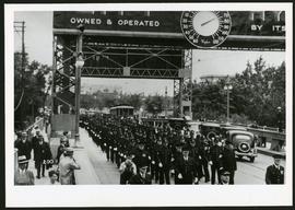
Police on Osborne Street Bridge during 1935 parade
A photograph of a parade on Osborne Street Bridge, taken 1935.
The W.R.E.N.C.H. Winnipeg Cycling Archive collection
Consists of digital and analogue records donated to the W.R.E.N.C.H. (Winnipeg Repair Education and Cycling Hub) in 2022 as part of a call to the community to create an archive of Winnipeg cycling and community organizing. Donors provided records to the W.R.E.N.C.H. with the understanding that they would be transferred to the City of Winnipeg Archives when the project was completed. The majority of donated records are digital, both born-digital and scans of analogue records, but analogue records were also included. The records include posters, pamphlets, minutes, and other documents created by Winnipeg cycling organizations, photographs and videos of cycling events and bike education, and content related to the interaction between community organizers and the police. Organizations represented within the records include Bike Winnipeg and Bike to the Future, Bike Week, and Critical Mass. The project was supported by the Winnipeg Foundation.
The W.R.E.N.C.H.