

Main Street North, Winnipeg, Manitoba, Canada
- i02165
- Item
- [194-?]
Print is a photographic image of Main Street North. The McLaren Hotel, Hotel Cornwall and C.P.R. Station can be seen in photograph
152 results directly related Exclude narrower terms
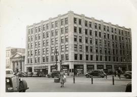
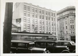
Main Street North, Winnipeg, Manitoba, Canada
Print is a photographic image of Main Street North. The McLaren Hotel, Hotel Cornwall and C.P.R. Station can be seen in photograph

Corner Portage Avenue and Main Street, Winnipeg, Manitoba
Print is a photographic image of the intersection of Portage Avenue and Main Street. Date of print is uncertain, [193-].
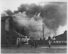
Arctic Ice Company's Bell Avenue yards fire, September 5, 1948
Stamp (on verso): Anderson-Brunnen Photographers, 410 Boyd Bldg. - Phone 93 900.
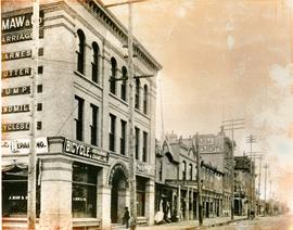
South West Corner of King and William
Item is a photographic reproduction, date unknown (original created ca. 1900). Shows the south west corner of King Street and William Avenue.
Photograph album of Winnipeg during WW1: Page 3
Item consists of a scrapbook page showing the Young Men's Christian Association (YMCA) Building at 301 Vaughan Street (Item 13); view of Portage Avenue with Eaton's and Boyd buildings in foreground and Hotel Fort Garry in the background (Item 14); view of Ashford's Bakery at Portage Avenue and Furby Street, facing south towards Broadway (Item 15); Vaughan Street facing north towards St. Paul's College on Ellice Avenue (Item 16). Dates of photographs are approximate, [ca. 1913].

Photograph album of Winnipeg during WW1: Page 6
Item consists of a scrapbook page showing soldiers marching in military parade on street in front of the Elliott and Hazel Grocers, 975 Main Street and the H. Lindster's Bakery, 971 Main Street (Item 25), soldiers lined up in military parade (Item 26),
soldiers marching in military parade (Item 27), soldiers marching in military parade (Item 28), [ca. 1913].
Photographs of buildings on Portage Avenue including the Bank of Montreal, Zeller's, the Power Building, Winnipeg Electric Co. and the Royal Bank Building.
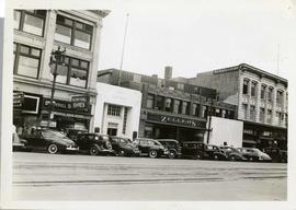
Storefronts on Portage Avenue between Carlton and Hargrave Streets
Cars and shoppers in front of stores on the north side of Portage Avenue, between Carlton and Hargrave Streets. Featured are The Berryhill Shoe Store in the Enderton / Mitchell-Copp Building, the Bank of Montreal, Zeller's (Zellers), and Rannards Shoes in

Portage Avenue looking west from Colony Street
A view of Portage Avenue looking west from Colony Street. The Hudson's Bay Company Building is featured prominantly and the Power Building and the Boyd Building are visible farther west.

Storefronts on Portage Avenue between Carlton and Hargrave Streets
Cars and shoppers in front of stores on the north side of Portage Avenue, between Carlton and Hargrave Streets. Featured are The Berryhill Shoe Store in the Enderton / Mitchell-Copp Building, the Bank of Montreal, and Zeller's (Zellers).

Portage Avenue looking west from Colony Street
A view of Portage Avenue looking west from Colony Street. The Hudson's Bay Company Building is featured prominantly and the Power Building is visible farther west. Playing "Young Mr. Lincoln", the Gaiety Theatre can be seen across the street with two poli
Storefronts in the Power Building
A view of cars and shoppers outside the Power Building at the corner of Portage Avenue and Vaughan Street. Street level storefronts include the Winnipeg Electric Company showroom and Rexall / Liggett's drug store. Above are the offices of Western Empire L
Power Building and Hudson's Bay Company Building
View of the North side of the corner of Portage Avenue and Vaughan Street, featuring the Power Building and Hudson's Bay Company Building. I front are parked cars and a street car passing by.

Dakota Village Shopping Centre panorama
View of Dakota Village Shopping Centre, 1077-1095 St. Mary's Road, 3.5 acres. From left to right: unknown stores, Ladies and Children's Wear, Lance Pharmacy, [Dakota?] Bowling, Shoe Fair, Bank of Nova Scotia, Safeway, apartment block, Bank of Montreal. Consists of 3 separate photographs pasted together on cardboard to create a panorama. The cardboard is a scrap made from an old sign of the Metropolitan Corporation of Greater Winnipeg (visible on the reverse). The cardboard is numbered “6”, presumably as part of a compilation with other shopping centre panoramas.
Metropolitan Corporation of Greater Winnipeg (Man.). Planning Division

Rossmere Shopping Centre panorama
View of Rossmere Shopping Centre, 1070 Henderson Highway, southwest corner Rowandale, 4.25 acres. From left to right: a garage or car wash, Red River Co-Op Store, Rossmere Lanes Bowling Alley, Library, Dry Cleaners, Co-operators Credit Union Society Limited, Rowandale Baptist Church, Rowandale Apartments, Red River Co-Op Gas Station. Consists of 3 separate photographs pasted together on cardboard to create a panorama. The cardboard is a scrap made from an old sign of the Metropolitan Corporation of Greater Winnipeg (visible on the reverse). The cardboard is numbered “2”, presumably as part of a compilation with other shopping centre panoramas.
Metropolitan Corporation of Greater Winnipeg (Man.). Planning Division

Southgate Shopping Centre panorama
View of Southgate Village Shopping Centre, 1305-1341 Pembina Highway at the southwest corner of McGillivray Boulevard, 3.3 acres. From left to right: Pembina Curling Rink, Imperial Cleaners, Safeway, The Place, Young Togs, Reid Marshall Pharmacy, The Village Gift Shop, The French Salon, Marshall Wells, The Toronto Dominion Bank, Safeway gas bar. Consists of 3 separate photographs pasted together on cardboard to create a panorama. The cardboard is a scrap made from an old sign of the Metropolitan Corporation of Greater Winnipeg (visible on the reverse). The cardboard is numbered “7”, presumably as part of a compilation with other shopping centre panoramas.
Metropolitan Corporation of Greater Winnipeg (Man.). Planning Division

Northdale Shopping Centre panorama
View of Northdale Shopping Centre, 963 Henderson Highway, 7.65 acres. From left to right: Loblaws Groceteria, Zeller's County Fair, various shops, the Royal Bank, the Canadian Imperial Bank of Commerce, A & P Food Store, Lord Wolseley School. Consists of 3 separate photographs pasted together on cardboard to create a panorama. The cardboard is a scrap made from an old sign of the Metropolitan Corporation of Greater Winnipeg (visible on the reverse). The cardboard is numbered “1”, presumably as part of a compilation with other shopping centre panoramas.
Metropolitan Corporation of Greater Winnipeg (Man.). Planning Division

Crossroads Shopping Centre panorama
View of Crossroads Shopping Centre, 1580 Regent Avenue W., 18 acres. From left to right: Woolco Department Store, Various shops, Safeway, Pacific 66 Gas Bar. Consists of 3 separate photographs pasted together on cardboard to create a panorama. The cardboard is a scrap made from an old sign of the Metropolitan Corporation of Greater Winnipeg (visible on the reverse). The cardboard is numbered “3”, presumably as part of a compilation with other shopping centre panoramas.
Metropolitan Corporation of Greater Winnipeg (Man.). Planning Division

Grant Plaza Shopping Centre panorama
View of Grant Park Plaza Shopping Centre, 1200-1216 Grant Avenue, 13.2 acres. From left to right: Clarks Discount Store, Dominion Store, Liquor Commission, Clarks Auto Centre. Consists of 3 separate photographs pasted together on cardboard to create a panorama. The cardboard is a scrap made from an old sign of the Metropolitan Corporation of Greater Winnipeg (visible on the reverse). The cardboard is numbered “8”, presumably as part of a compilation with other shopping centre panoramas.
Metropolitan Corporation of Greater Winnipeg (Man.). Planning Division

Southdale Shopping Centre panorama
View of Southdale Shopping Centre, 35 Lakewood Boulevard, 12.8 acres. From left to right: Dominion Store, Canadian Imperial Bank of Commerce, Mall Entrance, Quintons, Ebbeling Pharmacy, Kmart Department Store. Consists of 3 separate photographs pasted together on cardboard to create a panorama. The cardboard is a scrap made from an old sign of the Metropolitan Corporation of Greater Winnipeg (visible on the reverse). The cardboard is numbered “5”, presumably as part of a compilation with other shopping centre panoramas.
Metropolitan Corporation of Greater Winnipeg (Man.). Planning Division