
- i00342
- Item
- 1950
Part of City of Winnipeg (1874-1971)
A photograph taken during the 1950 flood, showing Maplewood Avenue and Bartlett Avenue. Item is 7 of 7 photographs on page 21 of scrapbook.
Harold K. White Studio
279 results directly related Exclude narrower terms
Part of City of Winnipeg (1874-1971)
A photograph taken during the 1950 flood, showing Maplewood Avenue and Bartlett Avenue. Item is 7 of 7 photographs on page 21 of scrapbook.
Harold K. White Studio
Dyke at rear of Shaarey Zedek (Wellington Crescent)
Part of City of Winnipeg (1874-1971)
A photograph taken during the 1950 flood, showing Dyke at rear of Shaarey Zedek (Wellington Crescent). Item is 2 of 8 photographs on page 90 of scrapbook.
Harold K. White Studio
Part of City of Winnipeg (1874-1971)
A photograph taken during the 1950 flood, showing Eccles. Item is 7 of 7 photographs on page 13 of scrapbook.
Harold K. White Studio
From 112 to 140 Bartlett Avenue
Part of City of Winnipeg (1874-1971)
A photograph taken during the 1950 flood, showing 112 Bartlett Avenue to 140 Bartlett Avenue. Item is 2 of 8 photographs on page 16 of scrapbook.
Harold K. White Studio
From 148 to 162 Bartlett Avenue
Part of City of Winnipeg (1874-1971)
A photograph taken during the 1950 flood, showing 148 Bartlett Avenue and 162 Bartlett Avenue. Item is 4 of 8 photographs on page 16 of scrapbook.
Harold K. White Studio
From 166 to 176 Bartlett Avenue
Part of City of Winnipeg (1874-1971)
A photograph taken during the 1950 flood, showing 166 Bartlett Avenue to 176 Bartlett Avenue. Item is 5 of 8 photographs on page 16 of scrapbook.
Harold K. White Studio
From 180 to 194 Bartlett Avenue
Part of City of Winnipeg (1874-1971)
A photograph taken during the 1950 flood, showing 180 Bartlett Avenue to 194 Bartlett Avenue. Item is 6 of 8 photographs on page 16 of scrapbook.
Harold K. White Studio
Part of City of Winnipeg (1874-1971)
A photograph taken during the 1950 flood, showing 42 Morley Avenue. Item is 1 of 8 photographs on page 10 of scrapbook.
Harold K. White Studio
Part of City of Winnipeg (1874-1971)
A photograph taken during the 1950 flood, showing Mabel Street. Item is 5 of 7 photographs on page 13 of scrapbook.
Harold K. White Studio
Part of City of Winnipeg (1874-1971)
A photograph taken during the 1950 flood, showing Mayfair Apartments. Item is 2 of 5 photographs on page 86 of scrapbook.
Harold K. White Studio
Part of City of Winnipeg (1874-1971)
A photograph taken during the 1950 flood, showing Morley Avenue Grocery located @ Morley and Fisher. Item is 2 of 8 photographs on page 11 of scrapbook.
Harold K. White Studio
Negatives - 2 views ? Baltimore Road
Part of City of Winnipeg (1874-1971)
Negatives - 2 views ? Baltimore Road Item is 6 of 6 negatives on page 27 of scrapbook.
Harold K. White Studio
New house, 129, 133, 137, 143 and 145 Maplewood Avenue
Part of City of Winnipeg (1874-1971)
A photograph taken during the 1950 flood, showing 129 Maplewood Avenue and 133 Maplewood Avenue and 137 Maplewood Avenue and 143 Maplewood Avenue and 145 Maplewood Avenue. Item is 3 of 5 photographs on page 22 of scrapbook.
Harold K. White Studio
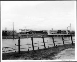
Part of City of Winnipeg (1874-1971)
A photograph of a flooded underpass on Pembina Highway during the 1950 flood in Winnipeg.
Harold K. White Studio
Scrapbook [1950 flood photographs]
Part of City of Winnipeg (1874-1971)
Subseries consists of a scrapbook assembled by the City Engineering Department to serve as photographic evidence of the 1950 flood. It contains black and white photographs that mostly document flooding in residential areas near the Red River (Fort Rouge, Riverview, North End, Point Douglas, Crescentwood, Armstrong's Point and others). Scrapbook appears to be organized geographically by area and street. In addition to documenting flooding, the photographs provide a detailed record of residential neighbourhoods, houses, streets, and businesses like corner grocery stores and laundries. All photographs were taken by Harold K. White Studio.
Winnipeg (Man.). City Engineer
S.E. Corner Arnold Avenue (100 Arnold?)
Part of City of Winnipeg (1874-1971)
A photograph taken during the 1950 flood, showing the southeast corner of Arnold Avenue and possibly 100 Arnold Avenue. Item is 7 of 8 photographs on page 1 of scrapbook.
Harold K. White Studio
S.W. Corner Arnold & Mabel (62?)
Part of City of Winnipeg (1874-1971)
A photograph taken during the 1950 flood, showing the southwest corner of Arnold Avenue and Mabel Avenue and possibly 62 Arnold Avenue. Item is 8 of 8 photographs on page 1 of scrapbook.
Harold K. White Studio
Under construction, Oakwood Street
Part of City of Winnipeg (1874-1971)
A photograph taken during the 1950 flood, showing Oakwood Street under construction. Item is 1 of 7 photographs on page 25 of scrapbook.
Harold K. White Studio
Part of City of Winnipeg (1874-1971)
A photograph taken during the 1950 flood, showing Wellington by Maryland Bridge. Item is 1 of 8 photographs on page 90 of scrapbook.
Harold K. White Studio