
Print preview Close
Showing 34 results
archival descriptions
Assiniboine Bridge

St. Boniface

Floods - St. Boniface and Norwood - April 1916

Rue Langevin, Floods, St. Boniface - April 1916

Winnipeg Boat Club under water, Norwood, April 1916

No. 4 Plan of City of Winnipeg and environs showing sewer district boundaries, trunk sewers, Greater Winnipeg Sanitary District Interceptor, sewage pumping stations and underpasses

Rue Langevin, St. Boniface under water floods April 1916, showing men in boat

Aerial of 1974 Flood – Red River between East and West Kildonan

Aerial of 1974 Flood – Pritchard Avenue Boat Dock and Redwood Bridge

Aerial of 1974 Flood – Fraser’s Grove Park

Women standing on flooded residential street with men in canoe, 1916 Flood, Norwood
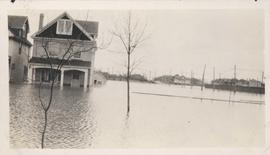
Flood water over front porch of home, 1916 Flood, Norwood

Wildwood Park - Three weeks before flood, 1950

Colony Street and Whitehall Avenue
Results 21 to 34 of 34
- « Previous
- 1
- 2