

- i00123
- Item
- May 15, 1950
Part of City of Winnipeg (1874-1971)
A photograph of children on Higgins Avenue during the 1950 flood. Piles of earth and sandbags line the street.
Harold K. White Studio
33 results with digital objects Show results with digital objects
Part of City of Winnipeg (1874-1971)
A photograph of children on Higgins Avenue during the 1950 flood. Piles of earth and sandbags line the street.
Harold K. White Studio

Part of City of Winnipeg (1874-1971)
A photograph of a flooded underpass on Higgins Avenue during the 1950 flood.
Harold K. White Studio
Photographs of overpasses and areas of the Greater Winnipeg Area for which overpasses were proposed.
Metropolitan Corporation of Greater Winnipeg (Man.). Information Officer

Pontoon Bridge, Fort Garry and Warehouse from south side Assiniboine River
Part of City of Winnipeg (1874-1971)

No. 8 A portion of the Lyndale dike in Norwood with the Norwood Bridge in the background
Photograph shows scene from 1950 flood. Description (on verso): Note the roof of the Greater Winnipeg Sanitary District Marion Street pumping station on the right. Stamp (on verso): City of Winnipeg - Engineering Dept., Water Works Division, Ross and Tecumseh.
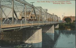
The Traffic Bridge over the Assiniboine River, Winnipeg
Date of postcard is uncertain, [before 1949].

Arlington Bridge from top of chimney
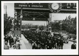
Police on Osborne Street Bridge during 1935 parade
A photograph of a parade on Osborne Street Bridge, taken 1935.

Arthur and Fred Landen photograph album – page 26
Page 26 of a photograph album created by brothers Arthur and Fred Landen of Hull, England. Page consists of 6 photographs taken by Fred Landen depicting, clockwise from top-left: Winnipeg’s second City Hall and the Volunteer Monument (which is captioned “Scott’s Monument, Fish Creek”); the Osborne Bridge over the Assiniboine River; a horse drawn sleigh carrying cords of wood in front of City Hall; a large house on Broadway, a dog sleigh in front of H. Laffrezen's Central Bakery at 333 1/2 William Avenue; and floating ice on the Assiniboine River.
Landen, Frederick Cluett

Aerial of 1974 Flood – Bergen Cutoff Bridge
Aerial photograph of the Bergen Cutoff Bridge during the 1974 Flood. The photograph faces northwest from Kildonan Drive in North Kildonan across the Red River towards Kildonan Park and Old Kildonan. The photographs were taken by the Department of Environmental Planning.
Winnipeg (Man.). Department of Environmental Planning
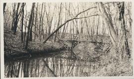
Photograph shows footbridge in wooded area, taken during the fall season. One of three photos mounted on page with caption "Scenes - Kildonan Park." Date of photograph is probable, [1923?].

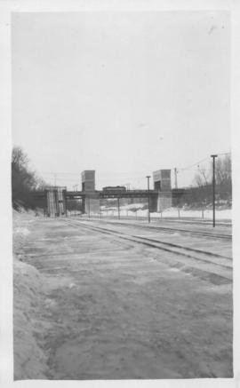
Foot of Water Street, C.N.R. Bridge - the Flood
Photograph is one of five photos mounted on page with caption "Assiniboine River flooded, Spring 1916."
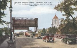
Osborne Street Bridge, showing the Dome of the Parliament Buildings, Winnipeg, Manitoba
Item consists of a postcard in printed format that shows the Osborne Street Bridge and the Manitoba Legislative Building. Motor vehicles and trolley shown crossing the bridge. Published by Valentine Edy Company, Limited, Winnipeg, Manitoba. Printed in Great Britain. Date of postcard is unknown.

A photograph of the Portage Avenue underpass, which crosses Century Street on the north side of the St. James Bridge. The photographer is unknown.
Metropolitan Corporation of Greater Winnipeg (Man.). Information Officer
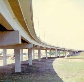
A colour photograph of the Nairn Overpass from below.
Metropolitan Corporation of Greater Winnipeg (Man.). Information Officer

Footbridge over Assiniboine River to City Park, Sunday afternoon
Date of photograph is approximate, ca. 1914.
Osborne bridge - toboggan slide, Winnipeg, Winter 1918

Photograph is one of five photos mounted on page with caption "Assiniboine River flooded, Spring 1916."
Photographs of the opening of the Nairn Overpass and green space near it.

Part of City of Winnipeg (1874-1971)
A photograph of Higgins Avenue during the 1950 flood. A bridge over the swollen Red River can also be seen.
Harold K. White Studio