

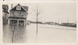
Floods - St. Boniface and Norwood - April 1916
- i01450
- Item
- 1916
Postcard is a photographic print showing water flooding homes. Photograph taken by Advance Photo Company, Winnipeg. Azo mark appears in stamp box, made in Canada.
Floods - St. Boniface and Norwood - April 1916
Postcard is a photographic print showing water flooding homes. Photograph taken by Advance Photo Company, Winnipeg. Azo mark appears in stamp box, made in Canada.

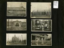
Photograph album of Winnipeg during WW1: Page 2
Item consists of a scrapbook page showing unidentified building (Item 7), Industrial Bureau Exhibition Building (Item 8), Canadian National Railway station (C.N.R. station) from Broadway looking east (Item 9), unidentified woman standing in front of residential building (Item 10), City Hall and Volunteer Monument (second City Hall) (Item 11), unidentified woman posing in front of what is likely the Assiniboine Park Pavilion (Item 12). Dates of photographs are approximate, [ca. 1913].
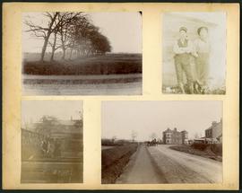
Arthur and Fred Landen photograph album – page 34
Page 34 of a photograph album created by brothers Arthur and Fred Landen of Hull, England. Page consists of 4 photographs taken by Fred Landen depicting, clockwise from top-left: a dirt road and field in Hull, England; two men posing for the camera in Hull, England; a horse drawn cart outside a large house in Hull, England; and a man and woman working in a garden in Hull, England.
Landen, Frederick Cluett

Aerial of 1974 Flood – Red River between East and West Kildonan
Aerial photograph of the Red River during the 1974 Flood. The photograph faces northwest from around Helmsdale Avenue and Kildonan Drive in East Kildonan towards Scotia Street in the Seven Oaks area of West Kildonan across the river. The photographs were taken by the Department of Environmental Planning.
Winnipeg (Man.). Department of Environmental Planning

Aerial of 1974 Flood – Pritchard Avenue Boat Dock and Redwood Bridge
Aerial photograph of the Red River during the 1974 Flood. The photograph faces northwest towards the North End, with the Pritchard Avenue Boat Dock in the bottom left and the Redwood Bridge in the top right. The photographs were taken by the Department of Environmental Planning.
Winnipeg (Man.). Department of Environmental Planning

Aerial of 1974 Flood – Fraser’s Grove Park
Aerial photograph of the Red River during the 1974 Flood. The photograph faces southwest from Fraser’s Grove Park and Kildonan Drive in East Kildonan towards Scotia Street in the Seven Oaks area of West Kildonan. The photographs were taken by the Department of Environmental Planning.
Winnipeg (Man.). Department of Environmental Planning
Flood water over front porch of home, 1916 Flood, Norwood
Photograph shows scene from the 1916 flooding of the Assiniboine River in Norwood, flood water levels high enough to submerge front porch of home on left side of photograph.

Wildwood Park - Three weeks before flood, 1950
Date of photograph is approximate, ca. 1914.
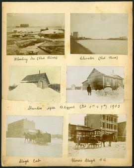
Arthur and Fred Landen photograph album – page 32
Page 32 of a photograph album created by brothers Arthur and Fred Landen of Hull, England. Page consists of 6 photographs taken by Fred Landen depicting, clockwise from top-left: ice floating on the Red River; a grain elevator on the banks of the Red River; a house buried in snow after the blizzard on February 8 and 9, 1905; a horse-drawn delivery sleigh from Imperial Dry Goods on Main Street in front of the old post office and the Conklins Land Office; a horse-drawn sleigh cab possibly outside the Assiniboine Block/Empire Hotel on Main Street; and another small house buried in snow after the blizzard on February 8 and 9, 1905.
Landen, Frederick Cluett

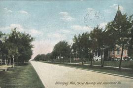
Winnipeg, Man., Corner Kennedy and Assiniboine Sts.
Postcard shows view of Kennedy Street, looking North from Assiniboine Avenue. Nicholas Bawlf residence, 11 Kennedy Street, shown at right foreground. Published by W. J. & Co. Ltd., Toronto, made in Germany. Date of postcard is approximate, ca. 1906.

Sandbags on the dyke (Wildwood Park - flood, 1950)

Exterior of home, 146 Spence Street, with woman sitting on porch railing
Photograph is one of four photos mounted on page with caption "Interior of Old Home - 146 Spence Street, Winnipeg, Man." Date of photograph is approximate, ca. 1914.
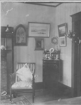
Interior of home, 146 Spence Street
Photograph is one of four photos mounted on page with caption "Interior of Old Home - 146 Spence Street, Winnipeg, Man." Date of photograph is approximate, ca. 1914.
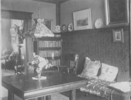
Interior of home, 146 Spence Street
Photograph is one of four photos mounted on page with caption "Interior of Old Home - 146 Spence Street, Winnipeg, Man." Date of photograph is approximate, ca. 1914.
![Father and mother [49 Balmoral Place]](/uploads/r/city-of-winnipeg-archives-amp-records-control-branch/6/a/d/6ad2c1a8b9486cbfe21cba66d596d3b1d9875c7c4d56a3091ed073858611c0fc/C0013_0000_0000_P0022_0095_063_142.jpg)
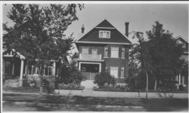
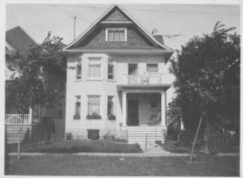
Our place - 49 Balmoral Place, Winnipeg, Manitoba
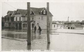
Winnipeg under water - April 1916
Postcard is a photographic print showing water flooding homes likely in St. Boniface. Unknown photographer, Noko mark appears in stamp box.