

Apartment block at 415 Edison Avenue
- i04658
- Item
- [197-?]
Apartment block at 415 Edison Avenue, near Rothesay Street.
Apartment block at 415 Edison Avenue
Apartment block at 415 Edison Avenue, near Rothesay Street.
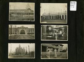
Photograph album of Winnipeg during WW1: Page 2
Item consists of a scrapbook page showing unidentified building (Item 7), Industrial Bureau Exhibition Building (Item 8), Canadian National Railway station (C.N.R. station) from Broadway looking east (Item 9), unidentified woman standing in front of residential building (Item 10), City Hall and Volunteer Monument (second City Hall) (Item 11), unidentified woman posing in front of what is likely the Assiniboine Park Pavilion (Item 12). Dates of photographs are approximate, [ca. 1913].
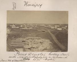
Point Douglas looking north with City Hall foundation in foreground, August 1875
Part of City of Winnipeg (1874-1971)
Photograph taken from top of Courthouse.
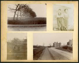
Arthur and Fred Landen photograph album – page 34
Page 34 of a photograph album created by brothers Arthur and Fred Landen of Hull, England. Page consists of 4 photographs taken by Fred Landen depicting, clockwise from top-left: a dirt road and field in Hull, England; two men posing for the camera in Hull, England; a horse drawn cart outside a large house in Hull, England; and a man and woman working in a garden in Hull, England.
Landen, Frederick Cluett

Preliminary Report on Residential Areas - Metropolitan Plan for Greater Winnipeg
Part of City Clerk's Library collection
Item consists of 1 report (60 pages), jointly prepared by the Metropolitan Planning Committee and Winnipeg Town Planning Commission. The report focuses on residential areas in the Greater Winnipeg Area. Part of the Metropolitan Plan for Greater Winnipeg - number 7 of master plan reports.
Manitoba. Metropolitan Planning Commission of Greater Winnipeg

The first side of an album page with a photograph of a Parks Board supervised skating rink outside Isaac Brock School and Chalmers United Church at Spruce Street and Barratt Avenue affixed.
Winnipeg (Man.). Parks and Recreation Department
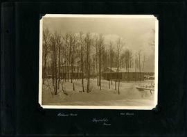
William Smaill Photo Album – Page 110
Part of William Smaill fonds
Captions read: Richan's house, our house, Reynolds, Manitoba.
Smaill, William
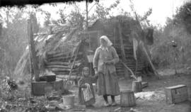
Only station woman on GWWD railway construction
Photograph of the only station woman for the construction of the Greater Winnipeg Water District Railway holding the hand of a child in front of a shelter, possibly near Shoal Lake. Photograph taken by C.J. Bruce, one of the Division Engineers for the Winnipeg Aqueduct.
Greater Winnipeg Water District
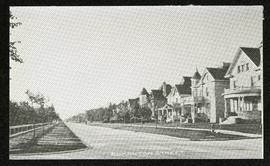
Part of Morris Block collection
Photograph of houses on Edmonton Street, likely south of Portage Avenue.
Block, Morris

Part of City of Winnipeg (1874-1971)
A photograph of high water surrounding a causeway that ran to the Rover Street hydro station during the 1950 flood.
Harold K. White Studio
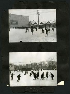
Two photographs of children playing hockey on outdoor skating rinks. Photo at top was taken outside the Northland Knitting Company building at 618 Arlington Street. Photo at bottom was taken on Scotia Street, near Luxton Avenue. The photographs are affixed to one side of a piece of construction paper that has two other photos on its reverse.
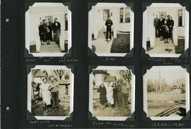
Scrapbook of Corporal Wallace – page 3
Page 3 of a photograph scrapbook made by Corporal John Wallace in April 1940. Photographs depict two families acquainted with Wallace: the Butlers (Jim Sr., Jim Jr., Les, Aggie, Gig, and Mrs. Butler) and the Drinkwaters (Mr. and Mrs. Drinkwater, Joan, Hilda, and Les), as well as Gladstone Manitoba. See general notes section for more details.
Wallace, John
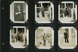
Scrapbook of Corporal Wallace – page 5
Page 5 of a photograph scrapbook made by Corporal John Wallace in April 1940. Photographs depict several acquaintenance of Wallace including two fellow soldiers, “Sonny” Robertson and Joseph “Fuss” McGrath, a Mrs. Penny, and a Frank Dowling and his family. See the general notes section for more details.
Wallace, John

Aerial of 1974 Flood – Pritchard Avenue Boat Dock and Redwood Bridge
Aerial photograph of the Red River during the 1974 Flood. The photograph faces northwest towards the North End, with the Pritchard Avenue Boat Dock in the bottom left and the Redwood Bridge in the top right. The photographs were taken by the Department of Environmental Planning.
Winnipeg (Man.). Department of Environmental Planning

Aerial of 1974 Flood – Fraser’s Grove Park
Aerial photograph of the Red River during the 1974 Flood. The photograph faces southwest from Fraser’s Grove Park and Kildonan Drive in East Kildonan towards Scotia Street in the Seven Oaks area of West Kildonan. The photographs were taken by the Department of Environmental Planning.
Winnipeg (Man.). Department of Environmental Planning

Aerial of 1974 Flood – Red River between East and West Kildonan
Aerial photograph of the Red River during the 1974 Flood. The photograph faces northwest from around Helmsdale Avenue and Kildonan Drive in East Kildonan towards Scotia Street in the Seven Oaks area of West Kildonan across the river. The photographs were taken by the Department of Environmental Planning.
Winnipeg (Man.). Department of Environmental Planning

Aerial of 1974 Flood – Bergen Cutoff Bridge
Aerial photograph of the Bergen Cutoff Bridge during the 1974 Flood. The photograph faces northwest from Kildonan Drive in North Kildonan across the Red River towards Kildonan Park and Old Kildonan. The photographs were taken by the Department of Environmental Planning.
Winnipeg (Man.). Department of Environmental Planning
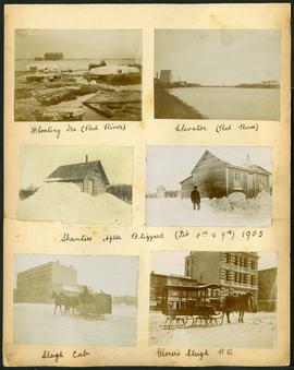
Arthur and Fred Landen photograph album – page 32
Page 32 of a photograph album created by brothers Arthur and Fred Landen of Hull, England. Page consists of 6 photographs taken by Fred Landen depicting, clockwise from top-left: ice floating on the Red River; a grain elevator on the banks of the Red River; a house buried in snow after the blizzard on February 8 and 9, 1905; a horse-drawn delivery sleigh from Imperial Dry Goods on Main Street in front of the old post office and the Conklins Land Office; a horse-drawn sleigh cab possibly outside the Assiniboine Block/Empire Hotel on Main Street; and another small house buried in snow after the blizzard on February 8 and 9, 1905.
Landen, Frederick Cluett

Aerial of 1974 Flood – Red River between North and West Kildonan
Aerial photograph of the Red River during the 1974 Flood. The photograph faces west from North Kildonan, where the Chief Peguis Trail now stands, across the river towards Kildonan Park and West Kildonan on the left, the North End Water Treatment Plant in the middle, and Old Kildonan on the right. The photographs were taken by the Department of Environmental Planning.
Winnipeg (Man.). Department of Environmental Planning

Arthur and Fred Landen photograph album – page 26
Page 26 of a photograph album created by brothers Arthur and Fred Landen of Hull, England. Page consists of 6 photographs taken by Fred Landen depicting, clockwise from top-left: Winnipeg’s second City Hall and the Volunteer Monument (which is captioned “Scott’s Monument, Fish Creek”); the Osborne Bridge over the Assiniboine River; a horse drawn sleigh carrying cords of wood in front of City Hall; a large house on Broadway, a dog sleigh in front of H. Laffrezen's Central Bakery at 333 1/2 William Avenue; and floating ice on the Assiniboine River.
Landen, Frederick Cluett