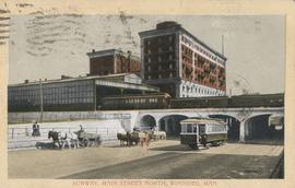
Showing 42 results

archival descriptions
Winnipeg (Man.). North End With digital objects
Print preview Hierarchy View:

Northgate Shopping Centre panorama

View of Northgate Plaza Shopping Centre, 1375-1425 McPhillips Street, 15 acres. From left to right: Clarks Discount Store, Various Shops, Northgate Bowling Lanes, Loblaw's. Consists of 3 separate photographs pasted together on cardboard to create a panorama. The cardboard is a scrap made from an old sign of the Metropolitan Corporation of Greater Winnipeg (visible on the reverse). The cardboard is numbered “14”, presumably as part of a compilation with other shopping centre panoramas.

Metropolitan Corporation of Greater Winnipeg (Man.). Planning Division

Rover Street Sub Station

A photograph of the Rover Street hydro station, surrounded by water, during the 1950 flood. A group of people are walking on the sandbag dike that surrounds the building.

Harold K. White Studio

1932 Relief Works and Committee Winnipeg

Photograph collage of the 1932 Winnipeg Relief Works and Committee. Portraits of committee members are surrounding photographs of projects the committee had worked on. The committee members are, clockwise from top left: Alderman John Blumberg, Alderman H. Andrews, City Clerk Magnus Peterson, Alderman J.A. Barry, Alderman A.A. Ryley, Alderman W.B. Simpson, City Engineer W.P. Brereton, G.W. Northwood, Alderman E.D. Honeyman, Mayor Ralph Webb, Alderman J.A. McKerschar, A. MacNamara, Resident Engineer A.J. Taunton, Alderman L.F. Borrowman, and Alderman C.E. Simonite. The works projects showcased in the center are, clockwise from top left: the Main Street Bridge, the Norwood Bridge, the Assiniboine Park Bridge, the Winnipeg Auditorium, the Sargent Park Swimming Pool, and the Salter Street Bridge. Created by Robson Photo.

North End Farmers' Market

Photograph shows the North End Farmer's Market (west side Main Street, north of Stella Avenue, looking west to King Street). Included in photograph: front entrance to market, automobiles parked on street, and North End Horse Exchange (523 King Street). Photograph likely taken from 919-921 Main Street by city employee.

North End Farmers' Market

Photograph shows the North End Farmer's Market, looking east across Main Street (northwest Main Street and Stella Avenue). Included in photograph: stalls filled with vegetables and people walking through the market, Aime Bicycle Shop, 909 Main Street, two-storey brick building (899-905 Main Street), and Norquay School.

Photograph album of Winnipeg during WW1: Page 5

Item consists of a scrapbook page showing soldiers lined up in military parade in front of the Industrial Bureau Exposition Building (Item 21), soldiers lined up in military parade (Item 22),
soldiers on horse in military parade in front of the Industrial Bureau Exposition Building (Item 23), crowd forming on street in front of the Israelite Jewish Daily newspaper building (975 Main Street) and the H. Lindster's Bakery (971 Main Street). Soldiers and Police in foreground (Item 24), [ca. 1913].

Photograph album of Winnipeg during WW1: Page 6

Item consists of a scrapbook page showing soldiers marching in military parade on street in front of the Elliott and Hazel Grocers, 975 Main Street and the H. Lindster's Bakery, 971 Main Street (Item 25), soldiers lined up in military parade (Item 26),
soldiers marching in military parade (Item 27), soldiers marching in military parade (Item 28), [ca. 1913].

Results 1 to 20 of 42