
Aerial of 1974 Flood – Pritchard Avenue Boat Dock and Redwood Bridge

Northgate Shopping Centre panorama
Scrapbook [1950 flood photographs]
Scrapbook [1950 flood photographs]

Rover Sub Station

Rover Street Sub Station
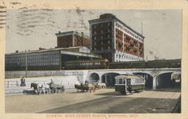
Subway, Main Street North, Winnipeg, Man.

Aerial view of Point Douglas, St. Boniface, and Elmwood areas

Central Business District: Aerial view - Central Winnipeg
![Vicinity of Elmwood Park [Aerial view]](/uploads/r/city-of-winnipeg-archives-amp-records-control-branch/5/b/9/5b929d618c2f619e557788462eee14587693511e7959bc6ca77ae96654d1bc98/C0013_0000_0000_P0018_0041_001_142.jpg)
Vicinity of Elmwood Park [Aerial view]
![Vicinity of Elmwood Park [Aerial view]](/uploads/r/city-of-winnipeg-archives-amp-records-control-branch/c/6/d/c6dc0bd0b8c2199f232fe8c7f5245d25e681a6a759be00e013a35a7a1ecada23/C0013_0000_0000_P0018_0042_001_142.jpg)
Vicinity of Elmwood Park [Aerial view]
![Logan Avenue and Main Street [Aerial view]](/uploads/r/city-of-winnipeg-archives-amp-records-control-branch/d/9/2/d92728eee72f0ac3b14bbb8ea8f04c5d3ece08f19538ee5d078eb79492de602b/C0013_0000_0000_P0018_0034_001_142.jpg)
Logan Avenue and Main Street [Aerial view]
![C.P.R. Yards looking West [Aerial view]](/uploads/r/city-of-winnipeg-archives-amp-records-control-branch/1/d/2/1d24b0471a50903dd76276838a7e169e4890a17020a9cfe6a0d34e153ebb9ec9/C0013_0000_0000_P0018_0027_001_142.jpg)
C.P.R. Yards looking West [Aerial view]

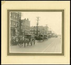
1932 Relief Works and Committee Winnipeg

North End Farmers' Market

North End Farmers' Market
Plans for Addition to Children's Hospital, Winnipeg Unit Shriners Hospitals for Crippled Children, Aberdeen Avenue
Plans for Addition to Children's Hospital, Winnipeg Unit Shriners Hospitals for Crippled Children, Aberdeen Avenue
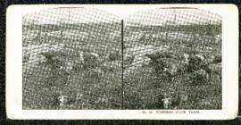
Eaton's promotional stereogram no. 12 - Winnipeg stock yards
Plans for Proposed Chapel and Autoposy Room, Childrens' Hospital
Plans for Proposed Chapel and Autoposy Room, Childrens' Hospital
Canada Bread delivery wagons at Main and Selkirk

Crane and David, Bakers and Confectioners
