

- i00119
- Item
- May 15, 1950
Part of City of Winnipeg (1874-1971)
A photograph of three people walking down Sutherland Avenue, near a rock causeway, during the 1950 flood. A boat is in a flooded ditch next to a sandbag dike.
Harold K. White Studio
Part of City of Winnipeg (1874-1971)
A photograph of three people walking down Sutherland Avenue, near a rock causeway, during the 1950 flood. A boat is in a flooded ditch next to a sandbag dike.
Harold K. White Studio

Part of City of Winnipeg (1874-1971)
A photograph of Higgins Avenue during the 1950 flood. A bridge over the swollen Red River can also be seen.
Harold K. White Studio

Part of City of Winnipeg (1874-1971)
A photograph of the Rover Street hydro station, surrounded by water, during the 1950 flood.
Harold K. White Studio

Part of City of Winnipeg (1874-1971)
A photograph of the Rover Street hydro station, surrounded by water, during the 1950 flood.
Harold K. White Studio

Part of City of Winnipeg (1874-1971)
A photograph of the Rover Street hydro station, surrounded by water, during the 1950 flood. A group of people are walking on the sandbag dike that surrounds the building.
Harold K. White Studio

Part of City of Winnipeg (1874-1971)
Photograph shows the North End Farmer's Market (west side Main Street, north of Stella Avenue, looking west to King Street). Included in photograph: front entrance to market, automobiles parked on street, and North End Horse Exchange (523 King Street). Photograph likely taken from 919-921 Main Street by city employee.

Part of City of Winnipeg (1874-1971)
Photograph shows the North End Farmer's Market, looking east across Main Street (northwest Main Street and Stella Avenue). Included in photograph: stalls filled with vegetables and people walking through the market, Aime Bicycle Shop, 909 Main Street, two-storey brick building (899-905 Main Street), and Norquay School.
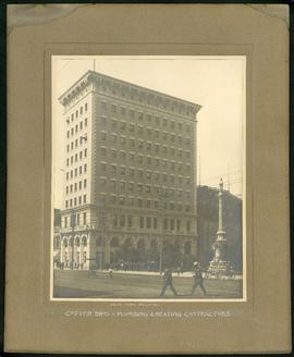
Union Bank Building – Cotter Brothers Plumbing and Heating
Part of Morris Block collection
Photograph mounted on cardboard of the Union Bank Building at Main St. and William Avenue and the Volunteer monument. The caption below the photograph implies that the photograph was taken by or for the Cotter Brothers – Plumbing and Heating Contractors.
Block, Morris
![C.P.R. Yards looking West [Aerial view]](/uploads/r/city-of-winnipeg-archives-amp-records-control-branch/1/d/2/1d24b0471a50903dd76276838a7e169e4890a17020a9cfe6a0d34e153ebb9ec9/C0013_0000_0000_P0018_0027_001_142.jpg)
C.P.R. Yards looking West [Aerial view]
Inscription (on recto): WG A114 30-2-42 CPR [Canadian Pacific Railway] RR [Railroad] Yards looking West.
![Vicinity of Elmwood Park [Aerial view]](/uploads/r/city-of-winnipeg-archives-amp-records-control-branch/c/6/d/c6dc0bd0b8c2199f232fe8c7f5245d25e681a6a759be00e013a35a7a1ecada23/C0013_0000_0000_P0018_0042_001_142.jpg)
Vicinity of Elmwood Park [Aerial view]
Inscription (on recto): WG M35: 3-16, 5 Mar '45, vicinity Elmwood Park Wpg, appr scale 1/12000.
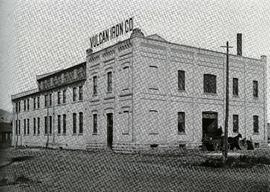
Photograph of the Vulcan Iron Works on page 153 of the Illustrated Souvenir of Winnipeg, published by W.M. Maretl and Sons, Half-Tone Engravers, in Winnipeg ca. 1903.

Aerial view of Point Douglas, St. Boniface, and Elmwood areas
Aerial photograph of Point Douglas, St. Boniface, and west Elmwood.

Waghorn's Guide map and street index
Part of City Clerk's Library collection
Waghorn's Guide - a small promotional pamphlet published by J.R. Waghorn in 1895. The pamphlet contains a street map of Winnipeg, a street index, and advertisements for various Winnipeg businesses including the Clarendon Hotel, the Redwood Brewery, and the Massey-Harris Company. The map shows the old City of Winnipeg from the Red River on the east to Waverly, Aubrey, and McPhillips Streets on the west, and from Athole Avenue (now Luxton Avenue) in the north to Parker Avenue in the south. Southern Elmwood, Old St. Boniface, and Norwood are also shown on the east side of the river. Railway lines are in black and electric street railway lines are in red.

Gladstone Street from Sutherland Avenue
Part of City of Winnipeg (1874-1971)
A photograph of flooding on Gladstone Street during the 1950 flood in Winnipeg. The photograph was taken from Sutherland Avenue.
Harold K. White Studio

Causeway to Rover Street Station
Part of City of Winnipeg (1874-1971)
A photograph of high water surrounding a causeway that ran to the Rover Street hydro station during the 1950 flood.
Harold K. White Studio
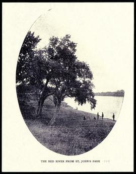
The Red River from St. John's Park.
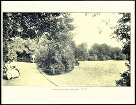
A quiet corner in St. John's Park.

Crane and David (Western Cake and Pie Co) storefront
Part of Morris Block collection
Group photograph mounted on cardboard of the staff of Crane and David, Bakers and Confectioners (also knows as the Western Cake and Pie Company) in front of their store at 765 Dufferin Avenue.
Block, Morris

Photograph album of Winnipeg during WW1: Page 6
Item consists of a scrapbook page showing soldiers marching in military parade on street in front of the Elliott and Hazel Grocers, 975 Main Street and the H. Lindster's Bakery, 971 Main Street (Item 25), soldiers lined up in military parade (Item 26),
soldiers marching in military parade (Item 27), soldiers marching in military parade (Item 28), [ca. 1913].
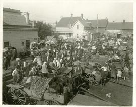
The North End market behind Dufferin Avenue and Derby Street
Carts of goods and shoppers in a bustling market around Dufferin Avenue and Derby Street in the North End.