
1997 flood - Kildonan Park - earthen dike
- i03226
- Pièce
- 1 May 1997
Fait partie de Winnipeg Flood Record and Archives Committee collection
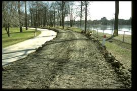
A photograph of an earthen dike in Kildonan Park during the 1997 flood.
Sans titre
1997 flood - Kildonan Park - earthen dike
Fait partie de Winnipeg Flood Record and Archives Committee collection
A photograph of an earthen dike in Kildonan Park during the 1997 flood.
Sans titre
1997 flood - Kildonan Park - military personnel making sandbags
Fait partie de Winnipeg Flood Record and Archives Committee collection
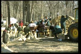
A photograph of military personnel making sandbags in Kildonan Park during the 1997 flood.
Sans titre

1997 flood - Kildonan Park - military personnel building a dike
Fait partie de Winnipeg Flood Record and Archives Committee collection
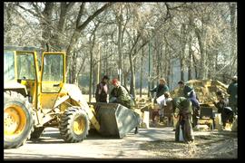
A photograph of military personnel building a sandbag dike in Kildonan Park during the 1997 flood.
Sans titre
1997 flood - Kildonan Park - military personnel making sandbags
Fait partie de Winnipeg Flood Record and Archives Committee collection
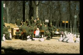
A photograph of military personnel making sandbags in Kildonan Park during the 1997 flood.
Sans titre
1997 flood - Kildonan Park - military personnel making sandbags
Fait partie de Winnipeg Flood Record and Archives Committee collection
A photograph of military personnel making sandbags in Kildonan Park during the 1997 flood.
Sans titre

Aerial of 1974 Flood – Fraser’s Grove Park
Fait partie de City of Winnipeg Archives Photograph collection
Aerial photograph of the Red River during the 1974 Flood. The photograph faces southwest from Fraser’s Grove Park and Kildonan Drive in East Kildonan towards Scotia Street in the Seven Oaks area of West Kildonan. The photographs were taken by the Department of Environmental Planning.
Sans titre

Aerial of 1974 Flood – Bergen Cutoff Bridge
Fait partie de City of Winnipeg Archives Photograph collection
Aerial photograph of the Bergen Cutoff Bridge during the 1974 Flood. The photograph faces northwest from Kildonan Drive in North Kildonan across the Red River towards Kildonan Park and Old Kildonan. The photographs were taken by the Department of Environmental Planning.
Sans titre

Aerial of 1974 Flood – Red River between North and West Kildonan
Fait partie de City of Winnipeg Archives Photograph collection
Aerial photograph of the Red River during the 1974 Flood. The photograph faces west from North Kildonan, where the Chief Peguis Trail now stands, across the river towards Kildonan Park and West Kildonan on the left, the North End Water Treatment Plant in the middle, and Old Kildonan on the right. The photographs were taken by the Department of Environmental Planning.
Sans titre

Aerial of 1974 Flood – Red River between East and West Kildonan
Fait partie de City of Winnipeg Archives Photograph collection
Aerial photograph of the Red River during the 1974 Flood. The photograph faces northwest from around Helmsdale Avenue and Kildonan Drive in East Kildonan towards Scotia Street in the Seven Oaks area of West Kildonan across the river. The photographs were taken by the Department of Environmental Planning.
Sans titre