

C.P.R. Depot and Royal Alexandra Hotel, Winnipeg, Manitoba
- i01807
- Item
- 1940
Photograph shows Canadian Pacific Railway depot and Royal Alexandra Hotel on Higgins Avenue. Date of photograph is approximate, ca. 1940.
957 results with digital objects Show results with digital objects
C.P.R. Depot and Royal Alexandra Hotel, Winnipeg, Manitoba
Photograph shows Canadian Pacific Railway depot and Royal Alexandra Hotel on Higgins Avenue. Date of photograph is approximate, ca. 1940.

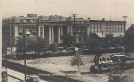
Canadian Pacific Railway depot (or station) shown in postcard. Published by Valentine & Sons' Publishing Co., Ltd., Montreal and Toronto, printed in Great Britain. Date of postcard is uncertain, [before 1949].
Canadian Pacific Railway. Postcard shows William Whyte Park and Countess of Dufferin in foreground, looking Northeast to C.P.R. Station and Dominion Immigration Hall. Date of postcard is approximate, ca. 1920.

C.P.R. Station, Winnipeg, Man.
Photograph shows Canadian Pacific Railway Station on Higgins Avenue. Date of photograph is approximate, ca. 1940.
![C.P.R. Yards looking West [Aerial view]](/uploads/r/city-of-winnipeg-archives-amp-records-control-branch/1/d/2/1d24b0471a50903dd76276838a7e169e4890a17020a9cfe6a0d34e153ebb9ec9/C0013_0000_0000_P0018_0027_001_142.jpg)
C.P.R. Yards looking West [Aerial view]
Inscription (on recto): WG A114 30-2-42 CPR [Canadian Pacific Railway] RR [Railroad] Yards looking West.

Crane and David, Bakers and Confectioners
Staff standing in front of Crane and David Bakers and Confectioners at 765 Dufferin Avenue and a horse-drawn delivery cart.
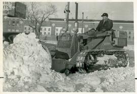
Crawler clearing snow on Notre Dame near Myrtle Street
A 325 Crawler machine clearing snow outside of the Christies Biscuits factory on Notre Dame Avenue near Myrtle Street.

Crestview Shopping Centre panorama
View of Crestview Shopping Centre, 3395 Portage Avenue, 8.3 acres. From left to right: Kmart Department Store, Dominion Store, Various Shops. Consists of 3 separate photographs pasted together on cardboard to create a panorama. The cardboard is a scrap made from an old sign of the Metropolitan Corporation of Greater Winnipeg (visible on the reverse). The cardboard is numbered “9”, presumably as part of a compilation with other shopping centre panoramas.
Metropolitan Corporation of Greater Winnipeg (Man.). Planning Division

Crossroads Shopping Centre panorama
View of Crossroads Shopping Centre, 1580 Regent Avenue W., 18 acres. From left to right: Woolco Department Store, Various shops, Safeway, Pacific 66 Gas Bar. Consists of 3 separate photographs pasted together on cardboard to create a panorama. The cardboard is a scrap made from an old sign of the Metropolitan Corporation of Greater Winnipeg (visible on the reverse). The cardboard is numbered “3”, presumably as part of a compilation with other shopping centre panoramas.
Metropolitan Corporation of Greater Winnipeg (Man.). Planning Division
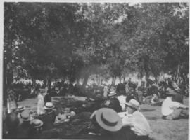
Crowd listening to Sunday band concerts, City Park
Date of photograph is approximate, ca. 1914.
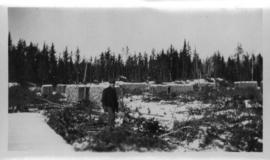
Cut and stacked cord wood at city wood camp, Greater Winnipeg Water District Railway
Photograph shows man standing by cut and stacked cords of wood. Date of photograph is approximate, ca. 1930.

Dakota Village Shopping Centre panorama
View of Dakota Village Shopping Centre, 1077-1095 St. Mary's Road, 3.5 acres. From left to right: unknown stores, Ladies and Children's Wear, Lance Pharmacy, [Dakota?] Bowling, Shoe Fair, Bank of Nova Scotia, Safeway, apartment block, Bank of Montreal. Consists of 3 separate photographs pasted together on cardboard to create a panorama. The cardboard is a scrap made from an old sign of the Metropolitan Corporation of Greater Winnipeg (visible on the reverse). The cardboard is numbered “6”, presumably as part of a compilation with other shopping centre panoramas.
Metropolitan Corporation of Greater Winnipeg (Man.). Planning Division

Date of photograph is probable, [1947?].
Harold K. White Studio

Delivery Truck, Lake of the Woods Milling Company
A delivery truck belonging to the Lake of the Woods Milling Company (later known as Five Roses Flour and merged with the Ogilvie Milling Company in 1954), which was based in Keewatin, Ontario.
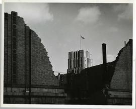
Demolition of the Orpheum Theatre
The Orpheum Theatre at 283 Fort Street undergoing demolition in 1946. The front tower of the Federal Building at 269 Main Street can be seen through the ruins.

Photograph shows construction of sewer. Date of photograph is uncertain, [before 1949].
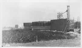
Photograph shows construction of sewer. Date of photograph is uncertain, [before 1949].
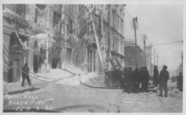
Postcard shows photographic image of the Dingwall Building on Albert Street after a fire.

Photograph shows dog sled, one of three photographs mounted on page with caption "River Park - Winter 1923."
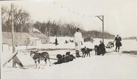
Photograph shows dog sled, one of three photos mounted on page with caption "River Park - Winter 1923."