
- i01714
- Item
- 1907
140 results with digital objects Show results with digital objects
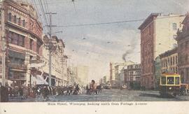
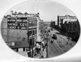
Main Street, Winnipeg, looking north from Portage Avenue
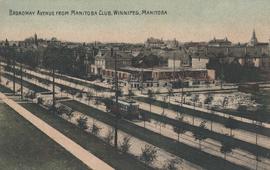
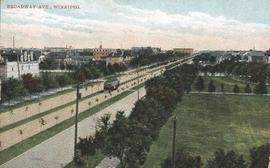
Broadway Avenue from Manitoba Club, Winnipeg
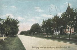
Winnipeg, Man., Corner Kennedy and Assiniboine Sts.
Postcard shows view of Kennedy Street, looking North from Assiniboine Avenue. Nicholas Bawlf residence, 11 Kennedy Street, shown at right foreground. Published by W. J. & Co. Ltd., Toronto, made in Germany. Date of postcard is approximate, ca. 1906.

Page shows five street views of Winnipeg, ca. 1903: 1) Main Street from Commercial Club, 2) Elgin Avenue, 3) Geo. Velie, Wholesale Wines and Liquors, 4) William Avenue, looking west, and 5) Main Street, looking north from Portage Avenue.
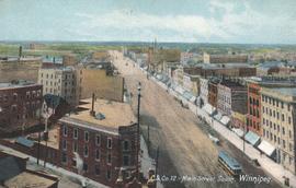
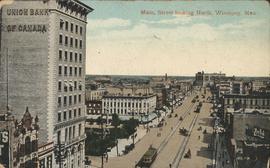
Main Street, looking north from Portage Avenue
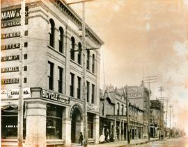
South West Corner of King and William
Item is a photographic reproduction, date unknown (original created ca. 1900). Shows the south west corner of King Street and William Avenue.
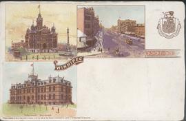
Canadian Postal Card showing Winnipeg City Hall, Main Street and Parliament Buildings
Postcard shows Winnipeg's second city hall (1886-1962), Main Street and Parliament buildings.

Waghorn's Guide map and street index
Part of City Clerk's Library collection
Waghorn's Guide - a small promotional pamphlet published by J.R. Waghorn in 1895. The pamphlet contains a street map of Winnipeg, a street index, and advertisements for various Winnipeg businesses including the Clarendon Hotel, the Redwood Brewery, and the Massey-Harris Company. The map shows the old City of Winnipeg from the Red River on the east to Waverly, Aubrey, and McPhillips Streets on the west, and from Athole Avenue (now Luxton Avenue) in the north to Parker Avenue in the south. Southern Elmwood, Old St. Boniface, and Norwood are also shown on the east side of the river. Railway lines are in black and electric street railway lines are in red.

Main Street Winnipeg looking south from City Hall
View of Main Street looking north
City of Winnipeg businesses shown in photograph: George Ashdown Hardware, Davis House, Symonds Furrier, Gable Hotel, J. Lister, Outfitter, Rossin House, the Blue Store, and the first City Hall is shown in background.

Winnipeg, Main Street looking south, Summer 1875
Part of City of Winnipeg (1874-1971)
Photograph taken from top of Courthouse.

Winnipeg, Main Street looking south, Spring of 1874
Part of City of Winnipeg (1874-1971)
Photograph taken from top of Courthouse.

Main Street looking north from Portage Avenue
Part of City of Winnipeg (1874-1971)
Bentley Building, Courthouse and Artesian well shown in photograph.

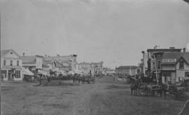
Main Street north of Portage Avenue
Photograph of a muddy Main Street in 1872, facing north from Portage Avenue and lined with shops on both sides, including a provisions store on the very right.

Main Street looking northeast to Grace Methodist Church
Photograph of a muddy Main Street in 1871, facing northeast from around St. Mary Avenue. Featured on the photograph's right-hand side is Grace Methodist Church, located at Main Street and Water Avenue (now William Stephenson Way), which was opened on September 17 of that year.

Part of City of Winnipeg (1874-1971)
A photograph of flooding in a residential area of Winnipeg during the 1950 flood. The photograph was taken at the intersection of Disraeli and Euclid.
Harold K. White Studio

Part of City of Winnipeg (1874-1971)
A photograph of flooding on Disraeli St during the 1950 flood. The photograph shows a child standing on a pile of lumber beside the flooded street.
Harold K. White Studio