
Osborne bridge - toboggan slide, Winnipeg, Winter 1918
- i02083
- Pièce
- 1918
Fait partie de City of Winnipeg Archives Photograph collection
351 résultats avec objets numériques Afficher les résultats avec des objets numériques
Osborne bridge - toboggan slide, Winnipeg, Winter 1918
Fait partie de City of Winnipeg Archives Photograph collection

Fait partie de City of Winnipeg Archives Photograph collection
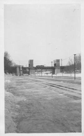
Photograph is one of five photos mounted on page with caption "Assiniboine River flooded, Spring 1916."

Foot of Water Street, C.N.R. Bridge - the Flood
Fait partie de City of Winnipeg Archives Photograph collection
Photograph is one of five photos mounted on page with caption "Assiniboine River flooded, Spring 1916."

Visit of Duke and Duchess of Cornwall & York (George V and Queen Mary)
Fait partie de City of Winnipeg Archives Photograph collection
Photograph showing an arch built near the C.P.R. Station in honour of a visit by the Duke and Duchess of Cornwall & York, George V and Queen Mary.
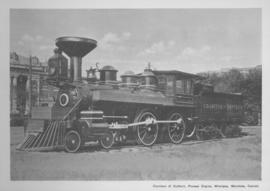
Countess of Dufferin, Pioneer Engine, Winnipeg, Manitoba
Fait partie de City of Winnipeg Archives Photograph collection
Print of a photographic image of the pioneer train engine Countess of Dufferin. Date of print is uncertain, [193-?].
Fait partie de City of Winnipeg Archives Photograph collection
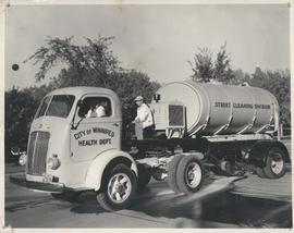
Photograph shows a street cleaning truck from the City of Winnipeg Health Department's Street Cleaining Division. Two City workers can be seen in the photograph. Date of photograph is uncertain.

The Cove Restaurant, corner of Portage and Carlton
Fait partie de City of Winnipeg Archives Photograph collection
Photograph of "The Cove" Restaurant at 355 Portage Avenue, at Carlton Street. The photograph was taken from a building on Carlton Street looking southeast towards the Eaton's Building, Mitchell-Copp, Zeller's, and the Carlton Building.

Winnipeg Electric Co. trolley bus
Fait partie de City of Winnipeg Archives Photograph collection
Photograph shows people waiting to board electric trolley bus (Winnipeg Electric Company), southbound Garry Street at Portage Avenue. Destination sign reads, No. 73 Sargent, Valour Road. Lindsay Building in background.

Arlington Bridge from top of chimney
Fait partie de City of Winnipeg Archives Photograph collection

Scrapbook of Corporal Wallace – page 2
Fait partie de City of Winnipeg Archives Photograph collection
Page 2 of a photograph scrapbook made by Corporal John Wallace in April 1940. Photos consist of Portage Avenue looking west from around Vaughn Street, a rail line at Portage Avenue and St. James Street, troops in formation, and Mrs. and Shirley Gardiner. See general notes section for more details.
Sans titre

Scrapbook of Corporal Wallace – page 9
Fait partie de City of Winnipeg Archives Photograph collection
Page 9 of a photograph scrapbook made by Corporal John Wallace in April 1940. Photographs depict a street in Gladstone Manitoba, a trolley bus in Winnipeg on Kennedy Street (between Ellice and Qu'Appelle), and the Butler family, acquaintances of Wallace. See page three of this scrapbook for more details on the Butler family.
Sans titre

1932 Relief Works and Committee Winnipeg
Fait partie de City of Winnipeg Archives Photograph collection
Photograph collage of the 1932 Winnipeg Relief Works and Committee. Portraits of committee members are surrounding photographs of projects the committee had worked on. The committee members are, clockwise from top left: Alderman John Blumberg, Alderman H. Andrews, City Clerk Magnus Peterson, Alderman J.A. Barry, Alderman A.A. Ryley, Alderman W.B. Simpson, City Engineer W.P. Brereton, G.W. Northwood, Alderman E.D. Honeyman, Mayor Ralph Webb, Alderman J.A. McKerschar, A. MacNamara, Resident Engineer A.J. Taunton, Alderman L.F. Borrowman, and Alderman C.E. Simonite. The works projects showcased in the center are, clockwise from top left: the Main Street Bridge, the Norwood Bridge, the Assiniboine Park Bridge, the Winnipeg Auditorium, the Sargent Park Swimming Pool, and the Salter Street Bridge. Created by Robson Photo.

Delivery Truck, Lake of the Woods Milling Company
Fait partie de City of Winnipeg Archives Photograph collection
A delivery truck belonging to the Lake of the Woods Milling Company (later known as Five Roses Flour and merged with the Ogilvie Milling Company in 1954), which was based in Keewatin, Ontario.
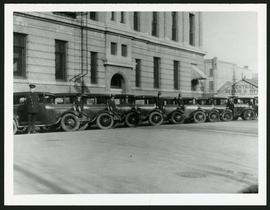
Police cars outside Rupert Avenue Police Station
Fait partie de City of Winnipeg Archives Photograph collection
A photograph of the Police Station and police car fleet on Rupert Avenue, taken ca. 1930.
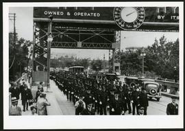
Police on Osborne Street Bridge during 1935 parade
Fait partie de City of Winnipeg Archives Photograph collection
A photograph of a parade on Osborne Street Bridge, taken 1935.

Northdale Shopping Centre panorama
Fait partie de City of Winnipeg Archives Photograph collection
View of Northdale Shopping Centre, 963 Henderson Highway, 7.65 acres. From left to right: Loblaws Groceteria, Zeller's County Fair, various shops, the Royal Bank, the Canadian Imperial Bank of Commerce, A & P Food Store, Lord Wolseley School. Consists of 3 separate photographs pasted together on cardboard to create a panorama. The cardboard is a scrap made from an old sign of the Metropolitan Corporation of Greater Winnipeg (visible on the reverse). The cardboard is numbered “1”, presumably as part of a compilation with other shopping centre panoramas.
Sans titre

Rossmere Shopping Centre panorama
Fait partie de City of Winnipeg Archives Photograph collection
View of Rossmere Shopping Centre, 1070 Henderson Highway, southwest corner Rowandale, 4.25 acres. From left to right: a garage or car wash, Red River Co-Op Store, Rossmere Lanes Bowling Alley, Library, Dry Cleaners, Co-operators Credit Union Society Limited, Rowandale Baptist Church, Rowandale Apartments, Red River Co-Op Gas Station. Consists of 3 separate photographs pasted together on cardboard to create a panorama. The cardboard is a scrap made from an old sign of the Metropolitan Corporation of Greater Winnipeg (visible on the reverse). The cardboard is numbered “2”, presumably as part of a compilation with other shopping centre panoramas.
Sans titre

Crossroads Shopping Centre panorama
Fait partie de City of Winnipeg Archives Photograph collection
View of Crossroads Shopping Centre, 1580 Regent Avenue W., 18 acres. From left to right: Woolco Department Store, Various shops, Safeway, Pacific 66 Gas Bar. Consists of 3 separate photographs pasted together on cardboard to create a panorama. The cardboard is a scrap made from an old sign of the Metropolitan Corporation of Greater Winnipeg (visible on the reverse). The cardboard is numbered “3”, presumably as part of a compilation with other shopping centre panoramas.
Sans titre

Clark’s Department Store at Highway 59 panorama
Fait partie de City of Winnipeg Archives Photograph collection
View of Clarks at Highway 59, southwest corner of Panet Road and Nairn Avenue, 8.5 acres. From left to right: B/A gas bar, Loblaws, Clarks Discount Store and Auto Centre, B/A gas bar, Kavanaugh's Hamburgers. Consists of 3 separate photographs pasted together on cardboard to create a panorama. The cardboard is a scrap made from an old sign of the Metropolitan Corporation of Greater Winnipeg (visible on the reverse). The cardboard is numbered “4”, presumably as part of a compilation with other shopping centre panoramas.
Sans titre

Southdale Shopping Centre panorama
Fait partie de City of Winnipeg Archives Photograph collection
View of Southdale Shopping Centre, 35 Lakewood Boulevard, 12.8 acres. From left to right: Dominion Store, Canadian Imperial Bank of Commerce, Mall Entrance, Quintons, Ebbeling Pharmacy, Kmart Department Store. Consists of 3 separate photographs pasted together on cardboard to create a panorama. The cardboard is a scrap made from an old sign of the Metropolitan Corporation of Greater Winnipeg (visible on the reverse). The cardboard is numbered “5”, presumably as part of a compilation with other shopping centre panoramas.
Sans titre