
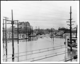
Main Street looking south from Main Street Bridge
- i00142
- Pièce
- 1950
Fait partie de City of Winnipeg (1874-1971)
A photograph of flooded Main Street, looking south from the Main Street Bridge, during the 1950 flood in Winnipeg.
Sans titre
250 résultats avec objets numériques Afficher les résultats avec des objets numériques
Main Street looking south from Main Street Bridge
Fait partie de City of Winnipeg (1874-1971)
A photograph of flooded Main Street, looking south from the Main Street Bridge, during the 1950 flood in Winnipeg.
Sans titre

Fait partie de City of Winnipeg (1874-1971)
A photograph of floodwater and sandbag dikes outside 368 and 372 Main Street during the 1950 flood in Winnipeg.
Sans titre

Fait partie de City of Winnipeg (1874-1971)
A photograph of the intersection of Broadway and Osborne Street during the 1950 flood in Winnipeg. The photo is taken from Osborne Street, looking north; the stone cross of All Saints' Church can be seen near the left side of the image.
Sans titre
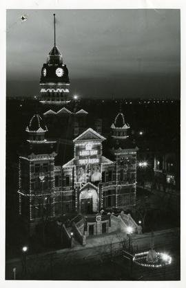
City Hall decorated for coronation
Fait partie de City of Winnipeg (1874-1971)
A photograph of City Hall decorated for the coronation of King George VI and Queen Elizabeth that took place on May 12, 1937. Sign reads, "LONG MAY THEY REIGN."
Sans titre
Fait partie de City of Winnipeg (1874-1971)
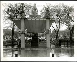
A photograph of a stage in front of City Hall, built for the visit to Winnipeg of Their Majesties King George VI and Queen Elizabeth on May 24, 1939.
Sans titre
Fait partie de City of Winnipeg (1874-1971)
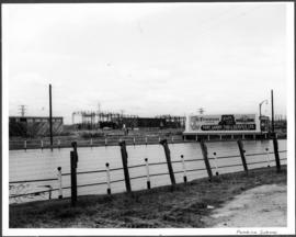
A photograph of a flooded underpass on Pembina Highway during the 1950 flood in Winnipeg.
Sans titre

Gladstone Street from Sutherland Avenue
Fait partie de City of Winnipeg (1874-1971)
A photograph of flooding on Gladstone Street during the 1950 flood in Winnipeg. The photograph was taken from Sutherland Avenue.
Sans titre

Sutherland Avenue at Brown & Rutherford building
Fait partie de City of Winnipeg (1874-1971)
A photograph of earthen and sandbag dikes on Sutherland Avenue near the intersection of Brown and Rutherford during the 1950 flood in Winnipeg.
Sans titre

Beginning of Causeway Sutherland at Disraeli
Fait partie de City of Winnipeg (1874-1971)
A photograph of equipment and vehicles at the beginning of a rock causeway at the intersection of Sutherland Avenue and Disraeli Street during the 1950 flood.
Sans titre

Fait partie de City of Winnipeg (1874-1971)
A photograph of three people walking down Sutherland Avenue, near a rock causeway, during the 1950 flood. A boat is in a flooded ditch next to a sandbag dike.
Sans titre

Fait partie de City of Winnipeg (1874-1971)
A photograph of flooding in a residential area of Winnipeg during the 1950 flood. The photograph was taken at the intersection of Disraeli and Euclid.
Sans titre

Fait partie de City of Winnipeg (1874-1971)
A photograph of flooding on Disraeli St during the 1950 flood. The photograph shows a child standing on a pile of lumber beside the flooded street.
Sans titre
Fait partie de City of Winnipeg (1874-1971)

Fait partie de City of Winnipeg (1874-1971)

Fait partie de City of Winnipeg (1874-1971)

Fait partie de City of Winnipeg (1874-1971)
A photograph of Higgins Avenue during the 1950 flood. A bridge over the swollen Red River can also be seen.
Sans titre

Fait partie de City of Winnipeg (1874-1971)
A photograph of children on Higgins Avenue during the 1950 flood. Piles of earth and sandbags line the street.
Sans titre

Fait partie de City of Winnipeg (1874-1971)
A photograph of a flooded underpass on Higgins Avenue during the 1950 flood.
Sans titre

Pumping water on Robert Street
Fait partie de City of Winnipeg (1874-1971)
A photograph of a pipe pouring water onto tracks on Robert Street (Galt Avenue) during the 1950 flood. A pile of wood is along one side of the street. The Ogilvie Flour Mill can be seen in the background.
Sans titre

Causeway to Rover Street Station
Fait partie de City of Winnipeg (1874-1971)
A photograph of high water surrounding a causeway that ran to the Rover Street hydro station during the 1950 flood.
Sans titre