
- d00945
- File
- 2018
Part of The W.R.E.N.C.H. Winnipeg Cycling Archive collection
Bike Week Winnipeg
351 results with digital objects Show results with digital objects
Part of The W.R.E.N.C.H. Winnipeg Cycling Archive collection
Bike Week Winnipeg
City of Winnipeg Active Transportation Study
Part of The W.R.E.N.C.H. Winnipeg Cycling Archive collection
Winnipeg (Man.)
City of Winnipeg Active Transportation Study
Part of The W.R.E.N.C.H. Winnipeg Cycling Archive collection
Winnipeg (Man.)

City of Winnipeg bicycle license plate
Part of The W.R.E.N.C.H. Winnipeg Cycling Archive collection
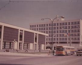
A photograph of the Civic Centre Complex, Winnipeg's third city hall (1964-present). Council Building, Administration Building, and public transit bus in view. Taken from William Avenue and Main Street, looking northwest. Date of photograph is uncertain, [197-?]. The photographer is likely Henry Kalen.
Kalen, Henry

Clark’s Department Store at Highway 59 panorama
View of Clarks at Highway 59, southwest corner of Panet Road and Nairn Avenue, 8.5 acres. From left to right: B/A gas bar, Loblaws, Clarks Discount Store and Auto Centre, B/A gas bar, Kavanaugh's Hamburgers. Consists of 3 separate photographs pasted together on cardboard to create a panorama. The cardboard is a scrap made from an old sign of the Metropolitan Corporation of Greater Winnipeg (visible on the reverse). The cardboard is numbered “4”, presumably as part of a compilation with other shopping centre panoramas.
Metropolitan Corporation of Greater Winnipeg (Man.). Planning Division

Clearing debris for aqueduct west of Snake Lake
Photograph of workers clearing debris between pole piling for the Winnipeg Aqueduct west of Snake Lake. Photographer is unknown.
Greater Winnipeg Water District
![CNR Yards [Aerial view]](/uploads/r/city-of-winnipeg-archives-amp-records-control-branch/3/a/c/3acce1afab65125da800d4ce81f386345349a1e9b9021d949ebfd6c8147f2db0/C0013_0000_0000_P0018_0044_001_142.jpg)
Inscription (on recto): WG M35: 3-8, 5 Mar '45, CNR Yards Wpg, appr scale 1/12000.
Part of Morris Block collection
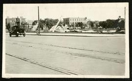
Photograph of a pile of collapsed advertisement signs on an otherwise empty lot.
Block, Morris
Part of The W.R.E.N.C.H. Winnipeg Cycling Archive collection
Scanned newspaper articles about competitive cycling.
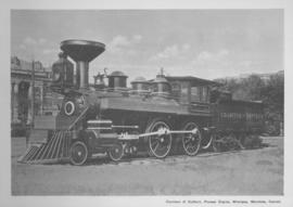
Countess of Dufferin, Pioneer Engine, Winnipeg, Manitoba
Print of a photographic image of the pioneer train engine Countess of Dufferin. Date of print is uncertain, [193-?].
![C.P.R. Yards looking West [Aerial view]](/uploads/r/city-of-winnipeg-archives-amp-records-control-branch/1/d/2/1d24b0471a50903dd76276838a7e169e4890a17020a9cfe6a0d34e153ebb9ec9/C0013_0000_0000_P0018_0027_001_142.jpg)
C.P.R. Yards looking West [Aerial view]
Inscription (on recto): WG A114 30-2-42 CPR [Canadian Pacific Railway] RR [Railroad] Yards looking West.

Crane and David, Bakers and Confectioners
Staff standing in front of Crane and David Bakers and Confectioners at 765 Dufferin Avenue and a horse-drawn delivery cart.
Crescentwood Park and Broadway
A photo album page with a view of Crescentwood Park on the first side and a view of Broadway from Main Street on the second side.

Crestview Shopping Centre panorama
View of Crestview Shopping Centre, 3395 Portage Avenue, 8.3 acres. From left to right: Kmart Department Store, Dominion Store, Various Shops. Consists of 3 separate photographs pasted together on cardboard to create a panorama. The cardboard is a scrap made from an old sign of the Metropolitan Corporation of Greater Winnipeg (visible on the reverse). The cardboard is numbered “9”, presumably as part of a compilation with other shopping centre panoramas.
Metropolitan Corporation of Greater Winnipeg (Man.). Planning Division
Part of The W.R.E.N.C.H. Winnipeg Cycling Archive collection
Content related to Critical Mass Winnipeg, including emails, photos, legal papers, and recordings.
Critical Mass Winnipeg

Part of The W.R.E.N.C.H. Winnipeg Cycling Archive collection
Critical Mass Winnipeg
Part of The W.R.E.N.C.H. Winnipeg Cycling Archive collection
Critical Mass Winnipeg
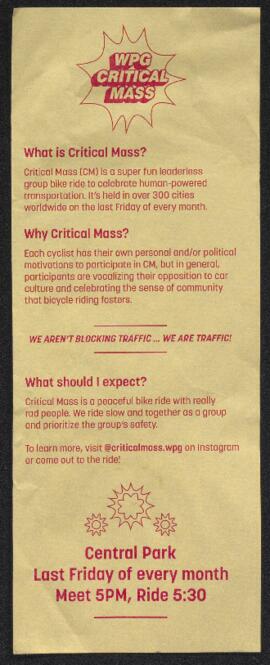
Critical Mass literature and advocacy
Part of The W.R.E.N.C.H. Winnipeg Cycling Archive collection
Scans of Critical Mass pamphlets and letters.
Critical Mass Winnipeg
Part of The W.R.E.N.C.H. Winnipeg Cycling Archive collection
Scanned photos of the Critical Mass bike rides on May 3 and 26, 2006 and the police response in particular.
Critical Mass Winnipeg