
- d00376
- Dossier
- 1925-1926
Fait partie de City of Winnipeg (1874-1971)
Consists of correspondence, invitations, and souvenir programmes related to the 1926 meeting of the Brotherhood of Locomotive Engineers.
Sans titre
93 résultats avec objets numériques Afficher les résultats avec des objets numériques
Fait partie de City of Winnipeg (1874-1971)
Consists of correspondence, invitations, and souvenir programmes related to the 1926 meeting of the Brotherhood of Locomotive Engineers.
Sans titre
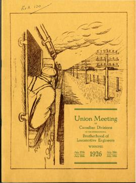
Souvenir Programme of Brotherhood of Locomotive Engineers meeting
Fait partie de City of Winnipeg (1874-1971)
A promotional souvenir programme of the 1926 union meeting of the Canadian Divisions of the International Brotherhood of Locomotive Engineers, held in Winnipeg on July 27-30, 1926. Booklet contains promotional information about and histories of the union, photographs of and statements made by union members and local politicians, and advertisements.
Sans titre
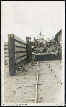
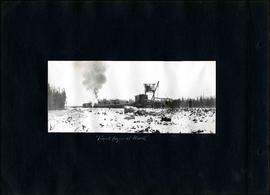
Work being done at Union Stock Yards
Fait partie de Morris Block collection
Sans titre
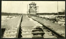
Interlocking tower over CNR track
Fait partie de Morris Block collection
The reverse reads “Inter-locking tower, Diamond over CNR”, followed by unreadable text.
Sans titre

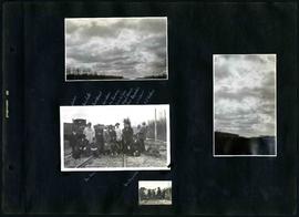
Fait partie de Morris Block collection
Photograph of a family standing on a platform or rail cart on rail tracks.
Sans titre
Fonds consists of a photo album created by William Smaill, Superintendent of the Winnipeg Aqueduct Construction Company, Ltd. The album contains photographs of the aqueduct’s construction, company men and their families, recreation, camps and homes used during construction, the Greater Winnipeg Water District Railway, and the surrounding landscape (Shoal Lake, Whitemouth River, Indian Bay, Birch River). There are also several photos of Winnipeg during Decoration Day 1914, photos of Mayors T.R. Deacon, Thomas Sharpe, and R.D. Waugh, and two photos of an Anishinaabe camp at Kekekoziibii Shoal Lake 40 First Nation.
The photos are heavily annotated. The annotations consist of names, locations, descriptions, and sometimes the section or specific mile of the aqueduct. A few photos appear to be missing and there are several loose pages with similar content. The photos are arranged somewhat chronologically – photos from 1914 generally precede photos from 1915 – but there are many exceptions.
Sans titre
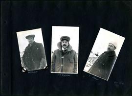
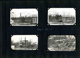
William Smaill Photo Album – Page 4
Fait partie de William Smaill fonds
Captions read: William Smaill - S.H. Reynolds - T. Sharpe - December 1914.
Sans titre
William Smaill Photo Album – Page 5
Fait partie de William Smaill fonds
Captions read: Track layer at work.
Sans titre

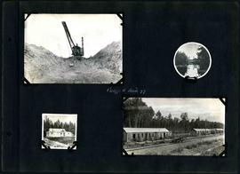
William Smaill Photo Album – Page 10
Fait partie de William Smaill fonds
Captions read: Views at Greater Winnipeg Water District gravel pit.
Sans titre
William Smaill Photo Album – Page 16
Fait partie de William Smaill fonds
Captions read: J. Nelson, Mrs. Carter, Mrs. Waugh, Miss James, Mr. Cummings, Mayor Waugh, Mrs. Reynolds, W.E. Davis, G.P. Richan, Tom Dunn, Sam Reynolds.
Sans titre
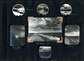
William Smaill Photo Album – Page 30
Fait partie de William Smaill fonds
Captions read: Whitemouth - Indian Bay - Heading west, mile 68 - Big muskeg, mile 91 - Mile 89 - Indian Bay.
Sans titre

William Smaill Photo Album – Page 34
Fait partie de William Smaill fonds
Sans titre
William Smaill Photo Album – Page 39
Fait partie de William Smaill fonds
Captions read: First setting up of inside forms, mile 51.
Sans titre
William Smaill Photo Album – Page 60
Fait partie de William Smaill fonds
Captions read: Camp 5, mile 77.
Sans titre
William Smaill Photo Album – Page 64
Fait partie de William Smaill fonds
Captions read: Camp 1, mile 51 1/2.
Sans titre
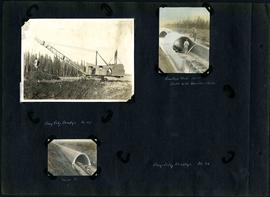
William Smaill Photo Album – Page 83
Fait partie de William Smaill fonds
1 photograph appears to be missing. Captions read: Bay City dredge, mile 91 - Cracked arch, mile 85, broke with traveler sacks - Mile 58 - Bay City dredge, Mile 91.
Sans titre
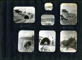
William Smaill Photo Album – Page 96
Fait partie de William Smaill fonds
Captions read: Arch, mile 65 - Harold, Monty - Invert, mile 65.
Sans titre

William Smaill Photo Album – loose page
Fait partie de William Smaill fonds
Captions read: Water tank, Indian Bay, Greater Winnipeg Water District.
Sans titre
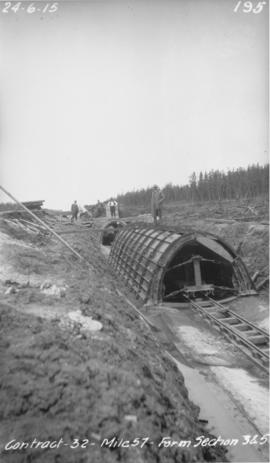
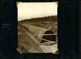
Winnipeg Aqueduct arch forms near Spruce Siding
Fait partie de Greater Winnipeg Water District fonds
Photograph of forms for arch sections three and five of the Winnipeg Aqueduct near Spruce Siding, Manitoba. Photograph taken by William G. Chace, Chief Engineer of the Winnipeg Aqueduct.
Sans titre

Waghorn's Guide map and street index
Fait partie de City Clerk's Library collection
Waghorn's Guide - a small promotional pamphlet published by J.R. Waghorn in 1895. The pamphlet contains a street map of Winnipeg, a street index, and advertisements for various Winnipeg businesses including the Clarendon Hotel, the Redwood Brewery, and the Massey-Harris Company. The map shows the old City of Winnipeg from the Red River on the east to Waverly, Aubrey, and McPhillips Streets on the west, and from Athole Avenue (now Luxton Avenue) in the north to Parker Avenue in the south. Southern Elmwood, Old St. Boniface, and Norwood are also shown on the east side of the river. Railway lines are in black and electric street railway lines are in red.