
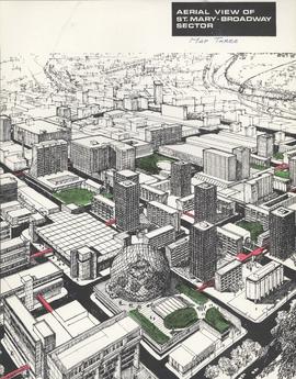
Downtown Winnipeg - Aerial view of St. Mary-Broadway Sector (Map Three)
- i01907
- Item
- 1969
Items shows drawing in printed format that record plans for downtown area.
Metropolitan Corporation of Greater Winnipeg (Man.). Planning Division
956 results with digital objects Show results with digital objects
Downtown Winnipeg - Aerial view of St. Mary-Broadway Sector (Map Three)
Items shows drawing in printed format that record plans for downtown area.
Metropolitan Corporation of Greater Winnipeg (Man.). Planning Division
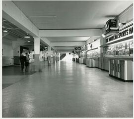
Manitoba Sports Hall of Fame display in Winnipeg Arena concourse
The concourse at the old Winnipeg Arena in the Polo Park Area. A display from the Manitoba Sports Hall of Fame is at right.
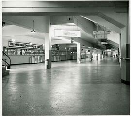
Manitoba Sports Hall of Fame display in Winnipeg Arena concourse
The concourse at the old Winnipeg Arena in the Polo Park Area. A display from the Manitoba Sports Hall of Fame is at left.
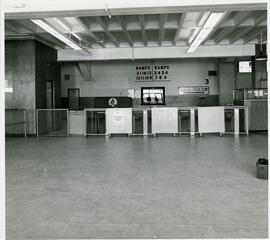
Off ramps in the Winnipeg Arena concourse
Blocked access to ramps in the old Winnipeg Arena concourse, in the Polo Park area. A sign points to the Manitoba Sports Hall of fame at right.
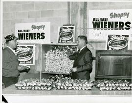
Shopsy hot dog stand in Winnipeg Arena concourse
Hot dogs piled up at the Shopsy hot dog stand in the old Winnipeg Arena concourse in the Polo Park area.
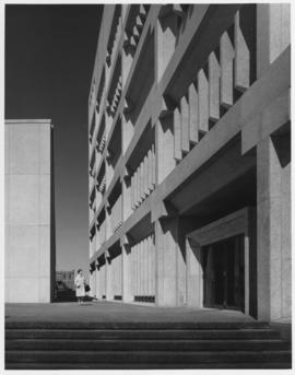
Public Safety Building (looking north, taken from bottom of steps to front entrance)
Photograph shows the Public Safety Building. Photograph by Henry Kalen.
Kalen, Henry
Photographs of buildings on Portage Avenue including the Bank of Montreal, Zeller's, the Power Building, Winnipeg Electric Co. and the Royal Bank Building.

Winnipeg Police Court / Civic Offices, 223 James Avenue
Former Winnipeg Police Court and now Civic office at 223 James Avenue.
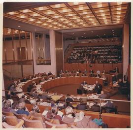
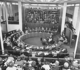
A photograph of City Council in session. Interior shot of Winnipeg's third City Hall (built 1964). Council Chambers and seated Councillors in view. At this time, Council included 50 Councillors. Photographer's stamp on verso. Date of photograph is 1972.
Allan, Hugh
A photograph of City Council in session. Interior shot of Winnipeg's third City Hall (built 1964). Council Chambers and seated Councillors in view. Photographer's stamp on verso. Date of photograph is 1972.
Allan, Hugh
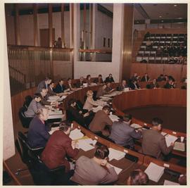
Inaugural Meeting of Council (first council meeting of Unicity)
Photograph documents the Inaugural Meeting of Council (first council meeting of Unicity), held Tuesday, January 4th, 1972, 2:00 pm (Council Chambers, Winnipeg City Hall).
Allan, Hugh
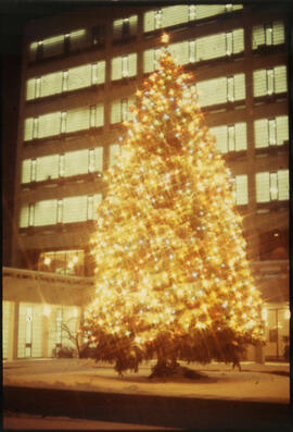
Photographs of the Christmas Tree at City Hall.
Christmas lights along Portage Avenue and Main Street
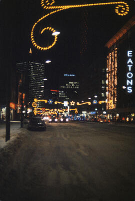
Christmas lights lit up along Portage Avenue, looking east towards Main Street, from about Carlton Street. Eaton’s Department Store is lit up on the right and the Royal Bank and Richardson buildings are lit in the distance.
Christmas lights along Portage, looking east from Carlton
Christmas lights along Portage Avenue, looking east from around Carlton Street. The Eaton’s Department Store is lit up on the right and the Richardson and Royal Bank buildings are lit in the distance.

Aerial of 1974 Flood – Red River between East and West Kildonan
Aerial photograph of the Red River during the 1974 Flood. The photograph faces northwest from around Helmsdale Avenue and Kildonan Drive in East Kildonan towards Scotia Street in the Seven Oaks area of West Kildonan across the river. The photographs were taken by the Department of Environmental Planning.
Winnipeg (Man.). Department of Environmental Planning

Aerial of 1974 Flood – Pritchard Avenue Boat Dock and Redwood Bridge
Aerial photograph of the Red River during the 1974 Flood. The photograph faces northwest towards the North End, with the Pritchard Avenue Boat Dock in the bottom left and the Redwood Bridge in the top right. The photographs were taken by the Department of Environmental Planning.
Winnipeg (Man.). Department of Environmental Planning

Aerial of 1974 Flood – Fraser’s Grove Park
Aerial photograph of the Red River during the 1974 Flood. The photograph faces southwest from Fraser’s Grove Park and Kildonan Drive in East Kildonan towards Scotia Street in the Seven Oaks area of West Kildonan. The photographs were taken by the Department of Environmental Planning.
Winnipeg (Man.). Department of Environmental Planning

Aerial of 1974 Flood – Bergen Cutoff Bridge
Aerial photograph of the Bergen Cutoff Bridge during the 1974 Flood. The photograph faces northwest from Kildonan Drive in North Kildonan across the Red River towards Kildonan Park and Old Kildonan. The photographs were taken by the Department of Environmental Planning.
Winnipeg (Man.). Department of Environmental Planning
Monty Hall at the Folklorama Kiev Pavilion
Monty Hall posing for a photograph at the Folklorama’s Kiev / Ukrainian Pavilion.