
- i04632
- Item
- [ca. 1970]
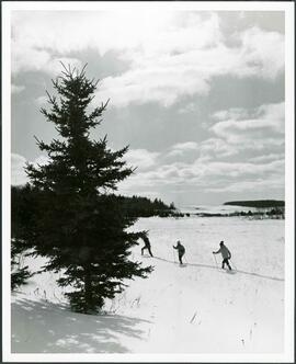
People cross-country skiing across a flat landscape.
Winnipeg (Man.). Parks and Recreation Department
3967 results with digital objects Show results with digital objects
People cross-country skiing across a flat landscape.
Winnipeg (Man.). Parks and Recreation Department
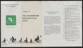
A guide to the Assiniboine Park bicycle path
Part of The W.R.E.N.C.H. Winnipeg Cycling Archive collection
Winnipeg (Man.)
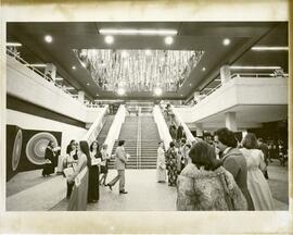
Winnipeg Convention Centre grand opening
Guests gather in front of the grand staircase for the grand opening of the Winnipeg Convention Centre on January 14, 1975.
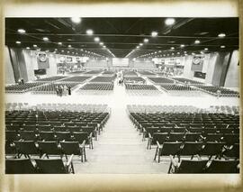
Winnipeg Convention Centre grand opening
Seating for around 5,000 guests attending the Winnipeg Convention Centre’s grand opening on January 14, 1975.
Part of City of St. Vital
Forms part of Fonds 10. Series consists of election project files and other documents and materials related to municipal elections in the Rural Municipality and City of St. Vital. It includes correspondence, poll results, declarations and oaths, nomination papers, permits, voters lists, etc. Majority of voters lists missing.
Series is arranged chronologically with later additions placed at end.
St. Vital (Man.)

Aerial of 1974 Flood – Red River between East and West Kildonan
Aerial photograph of the Red River during the 1974 Flood. The photograph faces northwest from around Helmsdale Avenue and Kildonan Drive in East Kildonan towards Scotia Street in the Seven Oaks area of West Kildonan across the river. The photographs were taken by the Department of Environmental Planning.
Winnipeg (Man.). Department of Environmental Planning

Aerial of 1974 Flood – Pritchard Avenue Boat Dock and Redwood Bridge
Aerial photograph of the Red River during the 1974 Flood. The photograph faces northwest towards the North End, with the Pritchard Avenue Boat Dock in the bottom left and the Redwood Bridge in the top right. The photographs were taken by the Department of Environmental Planning.
Winnipeg (Man.). Department of Environmental Planning

Aerial of 1974 Flood – Fraser’s Grove Park
Aerial photograph of the Red River during the 1974 Flood. The photograph faces southwest from Fraser’s Grove Park and Kildonan Drive in East Kildonan towards Scotia Street in the Seven Oaks area of West Kildonan. The photographs were taken by the Department of Environmental Planning.
Winnipeg (Man.). Department of Environmental Planning
Public Works and Local Improvements Files
Forms part of Fonds 3. Series consists of project files for various local improvements and specifications for public works projects in the Rural Municipality of Charleswood. Local improvement project files include correspondence, legal and financial records, petitions, public notices, tenders, drawings/plans, etc. Specifications for public works were assembled into packages by the Templeton Engineering Company, a consulting firm. These packages contain instructions to bidders, tender forms, agreements as well as other sections describing general conditions and special provisions. Drawings/plans commonly appear in packages.
Local improvement project files appear first, followed by specifications for public works projects. Original order was maintained by preserving the three alphabetical filing systems that comprise the local improvement project files, one of which has a distinct alpha-numeric filing system. Specifications for public works projects appear in chronological order. Files belonging to the City of Winnipeg removed.
Charleswood (Man.)
Part of Town of Tuxedo
Forms part of Fonds 7. Series consists of all surviving correspondence directed toward the Town of Tuxedo. The correspondence dates from the first year of the Town of Tuxedo’s incorporation, 1913, until 1974, slightly beyond its final year as a unique entity, 1971. The correspondence covers a wide variety of topics relating to the establishment of the town, health, schools, snow removal and taxation, with the greatest attention given to land development and all related issues. The records are arranged alphabetically by subject.
Included at the end of this series is early correspondence, 1914 to 1947, relating to public works and includes seven agreements.
Tuxedo (Man.)
Part of City of East Kildonan
Forms part of Fonds 8. Series consists of Lists of Voters, Lists of Electors, Electors' Rolls, Juror's Lists and general election material and correspondence for the R.M. of East Kildonan and the City of East Kildonan.
East Kildonan (Man.)

Aerial of 1974 Flood – Bergen Cutoff Bridge
Aerial photograph of the Bergen Cutoff Bridge during the 1974 Flood. The photograph faces northwest from Kildonan Drive in North Kildonan across the Red River towards Kildonan Park and Old Kildonan. The photographs were taken by the Department of Environmental Planning.
Winnipeg (Man.). Department of Environmental Planning
Photographs of various pumping stations throughout Winnipeg.
Heubach Park - South and North
Westview Park – Saskatchewan Landfill
Photographs of Westview Park and the Saskatchewan Landfill, its landscape, buildings, and park employees. Many of the photographs are affixed to pages.
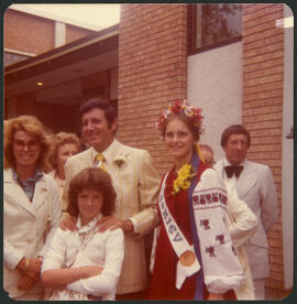
Monty Hall at the Folklorama Kiev Pavilion
Monty Hall posing for a photograph at the Folklorama’s Kiev / Ukrainian Pavilion.

Aerial of 1974 Flood – Red River between North and West Kildonan
Aerial photograph of the Red River during the 1974 Flood. The photograph faces west from North Kildonan, where the Chief Peguis Trail now stands, across the river towards Kildonan Park and West Kildonan on the left, the North End Water Treatment Plant in the middle, and Old Kildonan on the right. The photographs were taken by the Department of Environmental Planning.
Winnipeg (Man.). Department of Environmental Planning
Photographs of Xavier Park.

Bison statue and treescape in Xavier Park
Bison statue and treescape in Xavier Park
Winnipeg (Man.). Parks and Recreation Department

View of hill at Westview Park.
Winnipeg (Man.). Parks and Recreation Department