

Part of East Ward, St. Boniface in the distance
- i00030
- Pièce
- 1875
Fait partie de City of Winnipeg (1874-1971)
Photograph taken from top of Courthouse.
Part of East Ward, St. Boniface in the distance
Fait partie de City of Winnipeg (1874-1971)
Photograph taken from top of Courthouse.

Winnipeg, Main Street looking south, Spring of 1874
Fait partie de City of Winnipeg (1874-1971)
Photograph taken from top of Courthouse.
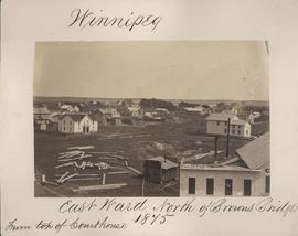
Winnipeg, East Ward, north of Browns Bridge, 1875
Fait partie de City of Winnipeg (1874-1971)
Photograph taken from top of Courthouse.

Causeway to Rover Street Station
Fait partie de City of Winnipeg (1874-1971)
A photograph of high water surrounding a causeway that ran to the Rover Street hydro station during the 1950 flood.
Sans titre

Fait partie de City of Winnipeg (1874-1971)
A photograph of flooding on Disraeli St during the 1950 flood. The photograph shows a child standing on a pile of lumber beside the flooded street.
Sans titre

Fait partie de City of Winnipeg (1874-1971)
A photograph of flooding in a residential area of Winnipeg during the 1950 flood. The photograph was taken at the intersection of Disraeli and Euclid.
Sans titre

Gladstone Street from Sutherland Avenue
Fait partie de City of Winnipeg (1874-1971)
A photograph of flooding on Gladstone Street during the 1950 flood in Winnipeg. The photograph was taken from Sutherland Avenue.
Sans titre

Fait partie de Parks and Recreation Photograph collection
The second side of an album page with a photograph of a Parks Board supervised skating rink outside the Norhtland Knitting Company Building at 618 Arlington Street affixed.
Sans titre

William Smaill Photo Album – Page 9
Fait partie de William Smaill fonds
Captions read: Station men's shack - Boggy number 1 - Hadashville - Settlers' house - Whitemouth - camp 3 - Indian Bay, April 1914.
Sans titre

William Smaill Photo Album – Page 13
Fait partie de William Smaill fonds
Captions read: Jackfish - Whitemouth - Trail, Indian Bay - Whitemouth - Birch River - Whitemouth - McLerie's.
Sans titre
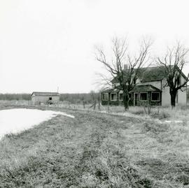
Area of John Blumberg Golf Course prior to construction.
Fait partie de Metropolitan Corporation of Greater Winnipeg
Photograph of abandoned buildings on a rural stretch of land in the area of what is now John Blumberg Golf Course. A description of the photo used for publication is recorded on a separate piece of paper. Photo's reverse is stamped by the Parks and Protection Division of the Metro Government.
Sans titre
William Smaill Photo Album – Page 90
Fait partie de William Smaill fonds
Captions read: Contains no captions.
Sans titre

William Smaill Photo Album – Page 95
Fait partie de William Smaill fonds
Captions read: Whitemouth River.
Sans titre
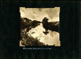
William Smaill Photo Album – Page 65
Fait partie de William Smaill fonds
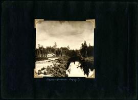
Captions read: Whitemouth River looking west from railway bridge..
Sans titre
William Smaill Photo Album – Page 55
Fait partie de William Smaill fonds
Captions read: Engineer's residence, boggy number 1.
Sans titre
William Smaill Photo Album – Page 58
Fait partie de William Smaill fonds
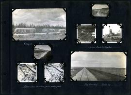
Captions read: Camp 6, mile 85 - 2 cubic yard bucket in muskeg - Shows how muskeg packs under pads - Big muskeg, mile 90.
Sans titre

William Smaill Photo Album – Page 56
Fait partie de William Smaill fonds
Captions read: Richan's house and ours at Whitemouth.
Sans titre
William Smaill Photo Album – Page 60
Fait partie de William Smaill fonds
Captions read: Camp 5, mile 77.
Sans titre

William Smaill Photo Album – Page 46
Fait partie de William Smaill fonds
Captions read: Vera S. - "EH?", "OH?" - Our home at Whitemouth River - Elsie.
Sans titre

William Smaill Photo Album – Page 37
Fait partie de William Smaill fonds
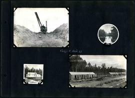
Captions read: Blaw Forms - Camp 2, Mile 57, Rear View - 8 foot clear muskeg - Camp 2, front view.
Sans titre