
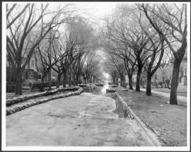
Flooding and diking in residential area
- i00166
- Item
- 1950
Part of City of Winnipeg (1874-1971)
A photograph of floodwater and sandbag dikes in a residential area during the 1950 flood in Winnipeg.
Harold K. White Studio
Flooding and diking in residential area
Part of City of Winnipeg (1874-1971)
A photograph of floodwater and sandbag dikes in a residential area during the 1950 flood in Winnipeg.
Harold K. White Studio
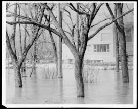
Part of City of Winnipeg (1874-1971)
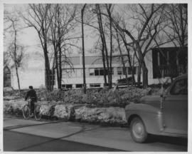
A photograph of floodwater surrounding trees during the 1950 flood. A building protected by a sandbag dike is in the background.
Harold K. White Studio
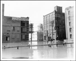
Part of City of Winnipeg (1874-1971)
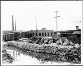
A photograph of floodwater surrounding the Canada Packers plant during the 1950 flood in Winnipeg.
Harold K. White Studio

Part of City of Winnipeg (1874-1971)
A photograph of flooding in a residential area of Winnipeg during the 1950 flood. The photograph was taken at the intersection of Disraeli and Euclid.
Harold K. White Studio
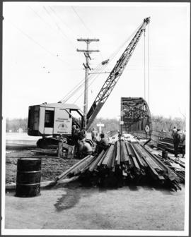
Part of City of Winnipeg (1874-1971)
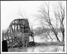
A photograph of construction equipment and lumber at the Elm Park Bridge during the 1950 flood in Winnipeg.
Harold K. White Studio
Part of City of Winnipeg (1874-1971)
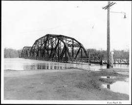
A photograph of the Elm Park Bridge during the 1950 flood in Winnipeg.
Harold K. White Studio
Part of City of Winnipeg (1874-1971)
A photograph of the Elm Park Bridge during the 1950 flood in Winnipeg.
Harold K. White Studio
Dyking built up around Shaarey Zedek Synagogue, 1950 Flood
Photograph taken at Shaarey Zedek Synagogue, 561 Wellington Crescent off Academy Road, on the western bank of the Assiniboine River. - Stamp (on verso): by Harold K. White Studio, 274 Fort St. Winnipeg, Phone 924 289.
Harold K. White Studio

Part of City of Winnipeg (1874-1971)
A photograph of flooding on Disraeli St during the 1950 flood. The photograph shows a child standing on a pile of lumber beside the flooded street.
Harold K. White Studio
Part of City of Winnipeg (1874-1971)
A photograph of a group of people sitting on a sandbag dike in Point Douglas during the 1950 flood in Winnipeg.
Harold K. White Studio
Part of City of Winnipeg (1874-1971)
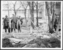
A photograph of three men building a dike during the 1950 flood.
Harold K. White Studio

Part of City of Winnipeg (1874-1971)
A photograph of floodwater being held back by a sandbag dike during the 1950 flood in Winnipeg.
Harold K. White Studio

Date of photograph is probable, [1947?].
Harold K. White Studio

Part of City of Winnipeg (1874-1971)
A photograph of high water surrounding a causeway that ran to the Rover Street hydro station during the 1950 flood.
Harold K. White Studio

Causeway to Rover Street Station
Part of City of Winnipeg (1874-1971)
A photograph of high water surrounding a causeway that ran to the Rover Street hydro station during the 1950 flood.
Harold K. White Studio

Part of City of Winnipeg (1874-1971)
A photograph of three people walking down Sutherland Avenue, near a rock causeway, during the 1950 flood. A boat is in a flooded ditch next to a sandbag dike.
Harold K. White Studio

Building Water Street causeway about 2nd day
Part of City of Winnipeg (1874-1971)
A photograph of the building of the Water Street causeway during the 1950 flood in Winnipeg. St. Boniface Cathedral can be seen in the background.
Harold K. White Studio
Part of City of Winnipeg (1874-1971)
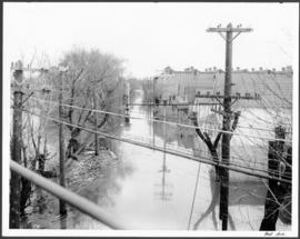
A photograph of hydro wires along flooded Bell Avenue during the 1950 flood in Winnipeg.
Harold K. White Studio

Beginning of Causeway Sutherland at Disraeli
Part of City of Winnipeg (1874-1971)
A photograph of equipment and vehicles at the beginning of a rock causeway at the intersection of Sutherland Avenue and Disraeli Street during the 1950 flood.
Harold K. White Studio

Bannerman and St. Cross looking east
Part of City of Winnipeg (1874-1971)
A photograph, looking east, of flooding at the intersection of Bannerman Avenue and St. Cross Street during the 1950 flood in Winnipeg.
Harold K. White Studio