

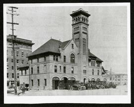
- i04543
- Item
- [ca. 1912]
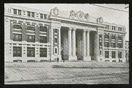
Part of Morris Block collection
Photograph of the Land Titles Building on Broadway and Memorial Boulevard.
Block, Morris
521 results with digital objects Show results with digital objects
Part of Morris Block collection
Photograph of the Land Titles Building on Broadway and Memorial Boulevard.
Block, Morris
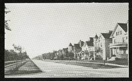
Part of Morris Block collection
Photograph of houses on Edmonton Street, likely south of Portage Avenue.
Block, Morris
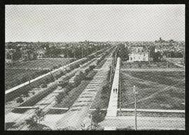
Broadway looking west from Fort Garry Court
Part of Morris Block collection
Photograph taken from Fort Garry Court, located at Broadway and Main Street, looking west down Broadway. St. Mary’s Academy, the Parliament Building (Legislature), and Law Courts are labeled off in the distance.
Block, Morris
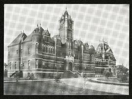
Part of Morris Block collection
Photograph of the old Winnipeg Law Courts Building.
Block, Morris
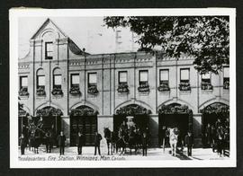
Fire Department no. 1, Albert and Bannatyne
Part of Morris Block collection
Photograph of the number 1 fire station at Albert Street and Bannatyne Avenue. Photograph is a reproduction of the original at the Archives of Manitoba.
Block, Morris
Fire Department no. 2, Smith and York
Part of Morris Block collection
Photograph of the number 2 fire station at Smith Street and York Avenue. Photograph is a reproduction of the original at the Archives of Manitoba.
Block, Morris
Part of Morris Block collection
Photograph of the main entrance to the Canadian Pacific Railway depot on Higgins Avenue.
Block, Morris
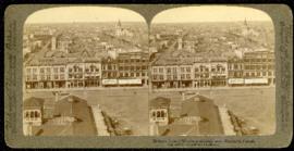
Birdseye view of Winnipeg – looking west from City Hall
Part of Morris Block collection
A promotional stereogram of Market Square, facing west from City Hall, made by Underwood and Underwood Publishers. The reverse side describes the scene in 6 languages.
Block, Morris
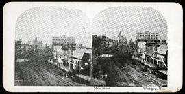
Part of Morris Block collection
Stereogram showing a view of Main Street north of Portage Avenue.
Block, Morris
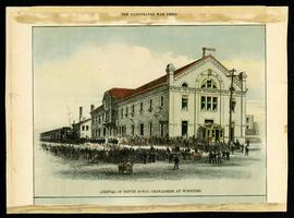
Arrival of Tenth Royal Grenadiers at Winnipeg
Part of Morris Block collection
Drawing of onlookers welcoming the Tenth Royal Grenadiers at the Canadian Pacific Railway station. The drawing is taken from the “Illustrated War News” and is mounted on cardboard.
Block, Morris

Part of Morris Block collection
Photograph of Upper Fort Garry mounted on cardboard. The photo was taken in 1878, but it is unclear when this actual record was cretated.
Block, Morris
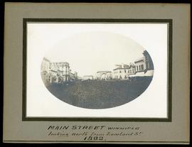
Main Street, looking north from Lombard
Part of Morris Block collection
Photograph mounted on cardboard of Main Street looking north from Lombard Avenue. The front of the record is dated as 1882, but the reverse side gives the dates as 1879-1880. It is unclear whether either of these dates refer specifically to the photograph of the entierty of the record.
Block, Morris
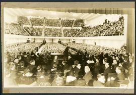
First recital at the Civic Auditorium
Part of Morris Block collection
Photograph mounted on cardboard of the first recital held at the newly built Civic Auditorium on November 9, 1932. Lawrence Tibbett was peforming with Stewart Wille on piano. The performance was part of the “Celebrity Concert Series” directed by Fred M. Gee. Photograph taken by P.M. Adam
Block, Morris

Banfiend’s Furniture carts in front of Empire Hotel
Part of Morris Block collection
Photograph mounted on cardboard of a cavalcade of horse-drawn wagons in front of the Empire Hotel on Main Street and York Avenue, advertising deals on 3-room furniture suites at Banfield’s Furniture, 492 Main Street.
Block, Morris
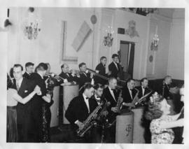
Claude Turner Band at the Fort Garry Hotel
Part of Owen Clark collection
Date of photograph is approximate, [ca. 1945].
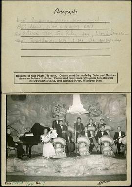
Promotional autograph card for the Cave Supper Club
Part of Owen Clark collection
A promotional card for the Cave Supper Club, located at the corner of Donald Street and Ellice Avenue. The inside has a dedicated space to collect autographs and has a photo of the The Cave Orchestra affixed (taken by Gibsons Photographers). The names of the band members are hand-written in the autograph section, from left to right: unknown on piano; Maxine Ware on vocals; "BB?" on drums; Stan Hykaway on bass; Ed Peterson on trombone; Joe Paley on saxophone; Lloyd Somers and Johnny Bering on trumpet; and unknown and Gil Hanson on saxophone. November 13, 1944 is written in the date section.
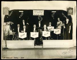
Johnny Bering and His Orchestra on air with CJRC at the St. Charles Hotel
Part of Owen Clark collection
Photograph of Johnny Bering and His Orchestra at the St. Charles Hotel. Their performance is being broadcast over the radio station CJRC. The photograph was taken by Carach Photo and is captioned "St. Charles Hotel - 1937" in black marker.

Children sitting on a bench in Central Park while a man mows the lawn in the background. Photograph taken by Lyall Commercial Photo Corporation, Ltd.


Waghorn's Guide map and street index
Part of City Clerk's Library collection
Waghorn's Guide - a small promotional pamphlet published by J.R. Waghorn in 1895. The pamphlet contains a street map of Winnipeg, a street index, and advertisements for various Winnipeg businesses including the Clarendon Hotel, the Redwood Brewery, and the Massey-Harris Company. The map shows the old City of Winnipeg from the Red River on the east to Waverly, Aubrey, and McPhillips Streets on the west, and from Athole Avenue (now Luxton Avenue) in the north to Parker Avenue in the south. Southern Elmwood, Old St. Boniface, and Norwood are also shown on the east side of the river. Railway lines are in black and electric street railway lines are in red.