

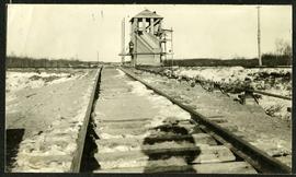
William Smaill Photo Album – Page 2
- p00120
- Part
- [1914 or 1915]
Part of William Smaill fonds
Captions read: First lift of ballast - Skeleton track - Joining the rails - Tracklayer at work.
Smaill, William
93 results with digital objects Show results with digital objects
William Smaill Photo Album – Page 2
Part of William Smaill fonds
Captions read: First lift of ballast - Skeleton track - Joining the rails - Tracklayer at work.
Smaill, William
Interlocking tower over CNR track
Part of Morris Block collection
The reverse reads “Inter-locking tower, Diamond over CNR”, followed by unreadable text.
Block, Morris
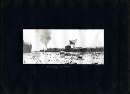
William Smaill Photo Album – Page 5
Part of William Smaill fonds
Captions read: Track layer at work.
Smaill, William

William Smaill Photo Album – Page 10
Part of William Smaill fonds
Captions read: Views at Greater Winnipeg Water District gravel pit.
Smaill, William
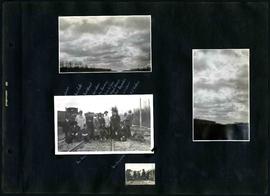
William Smaill Photo Album – Page 16
Part of William Smaill fonds
Captions read: J. Nelson, Mrs. Carter, Mrs. Waugh, Miss James, Mr. Cummings, Mayor Waugh, Mrs. Reynolds, W.E. Davis, G.P. Richan, Tom Dunn, Sam Reynolds.
Smaill, William
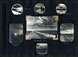
William Smaill Photo Album – Page 30
Part of William Smaill fonds
Captions read: Whitemouth - Indian Bay - Heading west, mile 68 - Big muskeg, mile 91 - Mile 89 - Indian Bay.
Smaill, William

William Smaill Photo Album – Page 34
Part of William Smaill fonds
Smaill, William
William Smaill Photo Album – Page 39
Part of William Smaill fonds
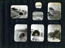
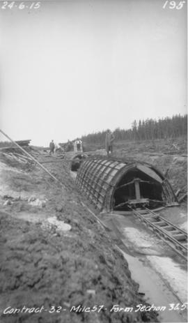
Captions read: First setting up of inside forms, mile 51.
Smaill, William
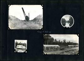
William Smaill Photo Album – Page 60
Part of William Smaill fonds
Captions read: Camp 5, mile 77.
Smaill, William
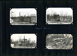
William Smaill Photo Album – Page 64
Part of William Smaill fonds
Captions read: Camp 1, mile 51 1/2.
Smaill, William
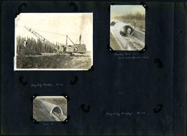
William Smaill Photo Album – Page 83
Part of William Smaill fonds
1 photograph appears to be missing. Captions read: Bay City dredge, mile 91 - Cracked arch, mile 85, broke with traveler sacks - Mile 58 - Bay City dredge, Mile 91.
Smaill, William
William Smaill Photo Album – Page 96
Part of William Smaill fonds
Captions read: Arch, mile 65 - Harold, Monty - Invert, mile 65.
Smaill, William

William Smaill Photo Album – loose page
Part of William Smaill fonds
Captions read: Water tank, Indian Bay, Greater Winnipeg Water District.
Smaill, William
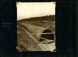
Winnipeg Aqueduct arch forms near Spruce Siding
Photograph of forms for arch sections three and five of the Winnipeg Aqueduct near Spruce Siding, Manitoba. Photograph taken by William G. Chace, Chief Engineer of the Winnipeg Aqueduct.
Greater Winnipeg Water District

Aqueduct siphon at Birch River crossing
Photograph of a Winnipeg Aqueduct siphon at the Birch River crossing near McMunn, Manitoba. Photographer is unknown.
Greater Winnipeg Water District
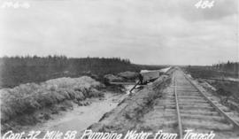
Pumping water from trench near Spruce Siding
Photograph of water being pumped from a trench next to the Greater Winnipeg Water District Railway near Spruce Siding, Manitoba, looking southeast. Photographer is unknown.
Greater Winnipeg Water District
Part of William Smaill fonds
Item consists of a photo album created by William Smaill, Superintendent of the Winnipeg Aqueduct Construction Company, Ltd. The album contains photographs of the aqueduct’s construction, company men and their families, recreation, camps and homes used during construction, the Greater Winnipeg Water District Railway, and the surrounding landscape (Shoal Lake, Whitemouth River, Indian Bay, Birch River). There are also several photos of Winnipeg during Decoration Day 1914, photos of Mayors T.R. Deacon, Thomas Sharpe, and R.D. Waugh, and two photos of an Anishinaabe camp at Kekekoziibii Shoal Lake 40 First Nation.
The photos are heavily annotated. The annotations consist of names, locations, descriptions, and sometimes the section or specific mile of the aqueduct. A few photos appear to be missing and there are several loose pages with similar content. The photos are arranged somewhat chronologically – photos from 1914 generally precede photos from 1915 – but there are many exceptions.
Smaill, William
Fonds consists of a photo album created by William Smaill, Superintendent of the Winnipeg Aqueduct Construction Company, Ltd. The album contains photographs of the aqueduct’s construction, company men and their families, recreation, camps and homes used during construction, the Greater Winnipeg Water District Railway, and the surrounding landscape (Shoal Lake, Whitemouth River, Indian Bay, Birch River). There are also several photos of Winnipeg during Decoration Day 1914, photos of Mayors T.R. Deacon, Thomas Sharpe, and R.D. Waugh, and two photos of an Anishinaabe camp at Kekekoziibii Shoal Lake 40 First Nation.
The photos are heavily annotated. The annotations consist of names, locations, descriptions, and sometimes the section or specific mile of the aqueduct. A few photos appear to be missing and there are several loose pages with similar content. The photos are arranged somewhat chronologically – photos from 1914 generally precede photos from 1915 – but there are many exceptions.
Smaill, William

Mixer site next to GWWD rail siding east of East Braintree
Photograph of a mixer site opposite Greater Winnipeg Water District siding rail line number 8, east of East Braintree, Manitoba. Photographer is unknown.
Greater Winnipeg Water District
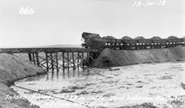
Filling in cofferdam for aqueduct's intake at Indian Bay
Photograph of dump cars filling in last gap of a cofferdam between dykes at the intake of the Winnipeg Aqueduct at Indian Bay, taken from the west dyke. Photographer is unknown.
Greater Winnipeg Water District