
- i00155
- Item
- 1950
Part of City of Winnipeg (1874-1971)
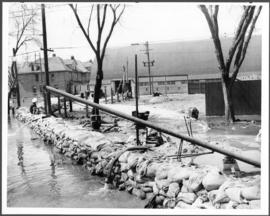
A photograph of a pump and a sandbag dike during the 1950 flood in Winnipeg.
Harold K. White Studio
Part of City of Winnipeg (1874-1971)
A photograph of a pump and a sandbag dike during the 1950 flood in Winnipeg.
Harold K. White Studio
Part of City of Winnipeg (1874-1971)
A photograph of two men working with pumps to remove water from the Norwood Bridge during the 1950 flood in Winnipeg.
Harold K. White Studio

Part of City of Winnipeg (1874-1971)
A photograph of a large pump on a residential street during the 1950 flood in Winnipeg.
Harold K. White Studio

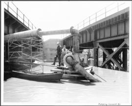
Pumping water on Robert Street
Part of City of Winnipeg (1874-1971)
A photograph of a pipe pouring water onto tracks on Robert Street (Galt Avenue) during the 1950 flood. A pile of wood is along one side of the street. The Ogilvie Flour Mill can be seen in the background.
Harold K. White Studio
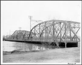
Part of City of Winnipeg (1874-1971)
A photograph of the Redwood Bridge during the 1950 flood in Winnipeg.
Harold K. White Studio
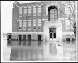
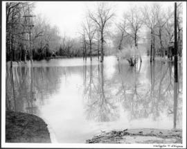
Part of City of Winnipeg (1874-1971)
A photograph of Riverview School, surrounded by floodwater, during the 1950 flood in Winnipeg.
Harold K. White Studio

Part of City of Winnipeg (1874-1971)
A photograph of the Rover Street hydro station, surrounded by water, during the 1950 flood.
Harold K. White Studio

Part of City of Winnipeg (1874-1971)
A photograph of the Rover Street hydro station, surrounded by water, during the 1950 flood. A group of people are walking on the sandbag dike that surrounds the building.
Harold K. White Studio

Part of City of Winnipeg (1874-1971)
A photograph of the Rover Street hydro station, surrounded by water, during the 1950 flood.
Harold K. White Studio
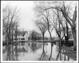
Part of City of Winnipeg (1874-1971)
A photograph of floodwaters at the corner of Scotia Street and Cathedral Avenue during the 1950 flood in Winnipeg.
Harold K. White Studio

Sutherland Avenue at Brown & Rutherford building
Part of City of Winnipeg (1874-1971)
A photograph of earthen and sandbag dikes on Sutherland Avenue near the intersection of Brown and Rutherford during the 1950 flood in Winnipeg.
Harold K. White Studio

Water Street Causeway to Provencher Bridge
Part of City of Winnipeg (1874-1971)
A photograph of vehicles driving down the Water Street causeway to the Provencher Bridge during the 1950 flood in Winnipeg.
Harold K. White Studio
Water Street from Provencher Bridge before causeway was built
Part of City of Winnipeg (1874-1971)
A photograph of flooded Water Street, taken from the Provencher Bridge, during the 1950 flood in Winnipeg. This photograph was taken before the causeway down Water Street was built.
Harold K. White Studio
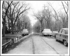
Part of City of Winnipeg (1874-1971)
A photograph of flooding at the corner of Wellington Crescent and Niagara Street during the 1950 flood in Winnipeg.
Harold K. White Studio

Part of City of Winnipeg (1874-1971)
A photograph of flooding at the corner of Wellington Crescent and Ash Street during the 1950 flood in Winnipeg.
Harold K. White Studio
Part of City of Winnipeg (1874-1971)
A photograph of flooding on West Gate during the 1950 flood in Winnipeg.
Harold K. White Studio

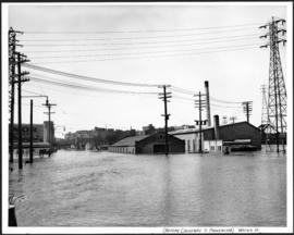
Winnipeg Electric Company building
Part of City of Winnipeg (1874-1971)
A photograph of the Winnipeg Electric Company building surrounded by water during the 1950 flood. Two men are in a boat in the floodwater outside the building.
Harold K. White Studio