
- s00254
- Série organique
- 1997
Fait partie de Winnipeg Flood Record and Archives Committee collection
355 résultats avec objets numériques Afficher les résultats avec des objets numériques
Fait partie de Winnipeg Flood Record and Archives Committee collection

Fait partie de City of Winnipeg (1874-1971)
A photograph of high water surrounding a power house during the 1950 flood.
Sans titre

Fait partie de City of Winnipeg (1874-1971)
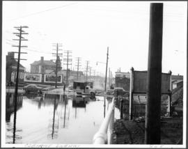
A photograph of a flooded underpass on Portage Avenue during the 1950 flood in Winnipeg.
Sans titre
Fait partie de City of Winnipeg (1874-1971)
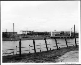
A photograph of a flooded underpass on Pembina Highway during the 1950 flood in Winnipeg.
Sans titre
Fait partie de City of Winnipeg (1874-1971)
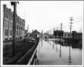
A photograph of an underpass on Osborne Street during the 1950 flood in Winnipeg.
Sans titre
Fait partie de City of Winnipeg (1874-1971)
A photograph of an underpass on Osborne Street during the 1950 flood in Winnipeg.
Sans titre
Fait partie de City of Winnipeg (1874-1971)
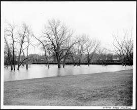
A photograph of the downstream Osborne Street Bridge during the 1950 flood in Winnipeg.
Sans titre

Fait partie de City of Winnipeg (1874-1971)
A photograph of the intersection of Broadway and Osborne Street during the 1950 flood in Winnipeg. The photo is taken from Osborne Street, looking north; the stone cross of All Saints' Church can be seen near the left side of the image.
Sans titre

Fait partie de City of Winnipeg (1874-1971)
A photograph of people boating down Oakwood Avenue in the Riverview neighbourhood during the 1950 flood in Winnipeg.
Sans titre
Fait partie de City of Winnipeg (1874-1971)
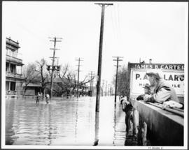
A photograph of flooded Notre Dame Avenue East during the 1950 flood in Winnipeg.
Sans titre
Fait partie de City of Winnipeg (1874-1971)
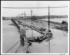
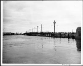
A photograph of the flooded Norwood Bridge during the 1950 flood in Winnipeg.
Sans titre
Fait partie de City of Winnipeg (1874-1971)
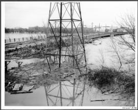
A photograph of a hydro tower and the flooded Norwood Bridge during the 1950 flood in Winnipeg.
Sans titre
Fait partie de City of Winnipeg (1874-1971)
A photograph of the flooded Norwood Bridge during the 1950 flood in Winnipeg.
Sans titre

Fait partie de City of Winnipeg (1874-1971)
A photograph of floodwater during the 1950 flood in Winnipeg. This photograph was taken looking north from the corner of Arnold Avenue and Hay Street; the Manitoba Legislature can be seen in the distance.
Sans titre

No. 8 A portion of the Lyndale dike in Norwood with the Norwood Bridge in the background
Fait partie de City of Winnipeg Archives Photograph collection
Photograph shows scene from 1950 flood. Description (on verso): Note the roof of the Greater Winnipeg Sanitary District Marion Street pumping station on the right. Stamp (on verso): City of Winnipeg - Engineering Dept., Water Works Division, Ross and Tecumseh.

Fait partie de City of Winnipeg Archives Photograph collection
Item is a photographic reproduction of map showing various sewer system details. Stamp (on verso): City of Winnipeg - Engineering Dept., Water Works Division, Ross and Tecumseh.
New house, 129, 133, 137, 143 and 145 Maplewood Avenue
Fait partie de City of Winnipeg (1874-1971)
A photograph taken during the 1950 flood, showing 129 Maplewood Avenue and 133 Maplewood Avenue and 137 Maplewood Avenue and 143 Maplewood Avenue and 145 Maplewood Avenue. Item is 3 of 5 photographs on page 22 of scrapbook.
Sans titre
Negatives - 2 views ? Baltimore Road
Fait partie de City of Winnipeg (1874-1971)
Negatives - 2 views ? Baltimore Road Item is 6 of 6 negatives on page 27 of scrapbook.
Sans titre
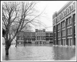
Fait partie de City of Winnipeg (1874-1971)
A photograph of the Municipal Hospitals on Morley Street, surrounded by floodwater, during the 1950 flood in Winnipeg.
Sans titre
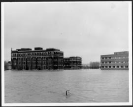
Fait partie de City of Winnipeg (1874-1971)
A photograph of the Municipal Hospitals on Morley Street, surrounded by floodwater, during the 1950 flood in Winnipeg.
Sans titre