

- i02111
- Item
- 1916
Photograph is one of five photos mounted on page with caption "Assiniboine River flooded, Spring 1916."
355 results with digital objects Show results with digital objects
Photograph is one of five photos mounted on page with caption "Assiniboine River flooded, Spring 1916."
S.E. Corner Arnold Avenue (100 Arnold?)
Part of City of Winnipeg (1874-1971)
A photograph taken during the 1950 flood, showing the southeast corner of Arnold Avenue and possibly 100 Arnold Avenue. Item is 7 of 8 photographs on page 1 of scrapbook.
Harold K. White Studio
Scrapbook [1950 flood photographs]
Part of City of Winnipeg (1874-1971)
Subseries consists of a scrapbook assembled by the City Engineering Department to serve as photographic evidence of the 1950 flood. It contains black and white photographs that mostly document flooding in residential areas near the Red River (Fort Rouge, Riverview, North End, Point Douglas, Crescentwood, Armstrong's Point and others). Scrapbook appears to be organized geographically by area and street. In addition to documenting flooding, the photographs provide a detailed record of residential neighbourhoods, houses, streets, and businesses like corner grocery stores and laundries. All photographs were taken by Harold K. White Studio.
Winnipeg (Man.). City Engineer
Part of City of Winnipeg (1874-1971)
A photograph taken during the 1950 flood, showing "Scotia Block" on Scotia Street. Item is 2 of 8 photographs on page 46 of scrapbook.
Harold K. White Studio
Part of City of Winnipeg (1874-1971)
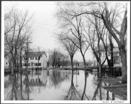
A photograph of floodwaters at the corner of Scotia Street and Cathedral Avenue during the 1950 flood in Winnipeg.
Harold K. White Studio

Sandbags on the dyke (Wildwood Park - flood, 1950)
![Sandbags - E sec [section] (Wildwood Park - flood, 1950)](/uploads/r/city-of-winnipeg-archives-amp-records-control-branch/c/4/a/c4a7e5ee657f2cf565da1e983d41beae65af0b67f4b9fb5fa71c540b99003de4/C0013_0000_0000_P0022_0094_001_142.jpg)
Sandbags - E sec [section] (Wildwood Park - flood, 1950)


Rue Langevin, Floods, St. Boniface - April 1916
Postcard is a photographic print showing flood water and debris around buildings. Photograph taken by Advance Photo Company, Winnipeg. Azo mark appears in stamp box, made in Canada.
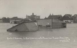
Rue De L'Hopital et Rue Langevin, St. Boniface Floods, April 1916
Postcard is a photographic print showing water flooding homes and other structures. Photograph taken by Advance Photo Company, Winnipeg. Azo mark appears in stamp box, made in Canada.

Part of City of Winnipeg (1874-1971)
A photograph of the Rover Street hydro station, surrounded by water, during the 1950 flood.
Harold K. White Studio

Part of City of Winnipeg (1874-1971)
A photograph of the Rover Street hydro station, surrounded by water, during the 1950 flood.
Harold K. White Studio

Part of City of Winnipeg (1874-1971)
A photograph of the Rover Street hydro station, surrounded by water, during the 1950 flood. A group of people are walking on the sandbag dike that surrounds the building.
Harold K. White Studio
Part of City of Winnipeg (1874-1971)
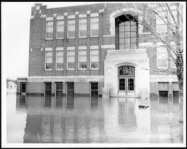
A photograph of Riverview School, surrounded by floodwater, during the 1950 flood in Winnipeg.
Harold K. White Studio
Part of City of Winnipeg (1874-1971)
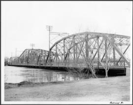
A photograph of the Redwood Bridge during the 1950 flood in Winnipeg.
Harold K. White Studio

Pumping water on Robert Street
Part of City of Winnipeg (1874-1971)
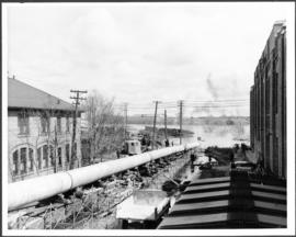
A photograph of a pipe pouring water onto tracks on Robert Street (Galt Avenue) during the 1950 flood. A pile of wood is along one side of the street. The Ogilvie Flour Mill can be seen in the background.
Harold K. White Studio

Part of City of Winnipeg (1874-1971)
A photograph of a large pump on a residential street during the 1950 flood in Winnipeg.
Harold K. White Studio
Part of City of Winnipeg (1874-1971)
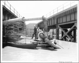
A photograph of two men working with pumps to remove water from the Norwood Bridge during the 1950 flood in Winnipeg.
Harold K. White Studio
Part of City of Winnipeg (1874-1971)
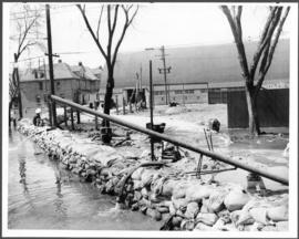
A photograph of a pump and a sandbag dike during the 1950 flood in Winnipeg.
Harold K. White Studio
Part of City of Winnipeg (1874-1971)
A photograph of a long pipe pumping water during the 1950 flood in Winnipeg.
Harold K. White Studio