Print preview Close

Showing 152 results

archival descriptions
Commercial buildings
Print preview Hierarchy View:

144 results with digital objects Show results with digital objects

Five street views

Page shows five street views of Winnipeg, ca. 1903: 1) Main Street from Commercial Club, 2) Elgin Avenue, 3) Geo. Velie, Wholesale Wines and Liquors, 4) William Avenue, looking west, and 5) Main Street, looking north from Portage Avenue.

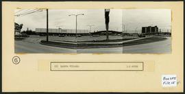
Dakota Village Shopping Centre panorama

View of Dakota Village Shopping Centre, 1077-1095 St. Mary's Road, 3.5 acres. From left to right: unknown stores, Ladies and Children's Wear, Lance Pharmacy, [Dakota?] Bowling, Shoe Fair, Bank of Nova Scotia, Safeway, apartment block, Bank of Montreal. Consists of 3 separate photographs pasted together on cardboard to create a panorama. The cardboard is a scrap made from an old sign of the Metropolitan Corporation of Greater Winnipeg (visible on the reverse). The cardboard is numbered “6”, presumably as part of a compilation with other shopping centre panoramas.

Metropolitan Corporation of Greater Winnipeg (Man.). Planning Division

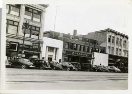
North side of Lombard, Rorie to Main Street

A photograph of storefronts and advertisements on the north side of Lombard Avenue, between Rorie Street and Main Street. The photograph is part of small album containing photographs of maps tracking the outbreak of typhoid from 1905 to 1909 and other scenes. Item is loose and at back of album.

City Hall and courtyard, facing Market Avenue

Photograph of the front side of Winnipeg's second City Hall, facing towards Market Avenue. Also featured in the photograph is the green space in front of City Hall, the Jubilee Fountain, the Volunteer Monument, businesses and store fronts on Market Avenue, and the McLaren and Cornwall Hotels in the distance. Photographed by Henry Kalen.

Metropolitan Corporation of Greater Winnipeg (Man.). Information Officer

Results 21 to 40 of 152