
- i01446
- Item
- [between 1914 and 1918]
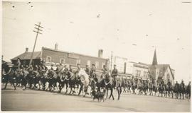
Photograph shows Lord Strathcona Horse, just before departure overseas during World War 1, at Selkirk and Main, looking at the east side of Main Street..
42 results with digital objects Show results with digital objects
Photograph shows Lord Strathcona Horse, just before departure overseas during World War 1, at Selkirk and Main, looking at the east side of Main Street..

Central Business District: Aerial view - Central Winnipeg
Date of photograph is approximate, ca. 1947.
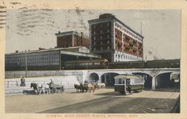
Subway, Main Street North, Winnipeg, Man.
Postcard shows C.P.R. Subway (Canadian Pacific Railway), looking south from Sutherland Avenue. Royal Alexandra Hotel and C.P.R. train sheds in view. Postmarked and note written on back. Date of postcard is uncertain, [before 1949].
![C.P.R. Yards looking West [Aerial view]](/uploads/r/city-of-winnipeg-archives-amp-records-control-branch/1/d/2/1d24b0471a50903dd76276838a7e169e4890a17020a9cfe6a0d34e153ebb9ec9/C0013_0000_0000_P0018_0027_001_142.jpg)
C.P.R. Yards looking West [Aerial view]
Inscription (on recto): WG A114 30-2-42 CPR [Canadian Pacific Railway] RR [Railroad] Yards looking West.
![Logan Avenue and Main Street [Aerial view]](/uploads/r/city-of-winnipeg-archives-amp-records-control-branch/d/9/2/d92728eee72f0ac3b14bbb8ea8f04c5d3ece08f19538ee5d078eb79492de602b/C0013_0000_0000_P0018_0034_001_142.jpg)
Logan Avenue and Main Street [Aerial view]
Inscription (on recto): A160 3-9-43 Logan Ave and Main St Wpg [Winnipeg] about 4000' 5".
![Vicinity of Elmwood Park [Aerial view]](/uploads/r/city-of-winnipeg-archives-amp-records-control-branch/5/b/9/5b929d618c2f619e557788462eee14587693511e7959bc6ca77ae96654d1bc98/C0013_0000_0000_P0018_0041_001_142.jpg)
Vicinity of Elmwood Park [Aerial view]
Inscription (on recto): WG M35: 3-15, 5 Mar '45, vicinity Elmwood Park Wpg, appr. scale 1/12000.
![Vicinity of Elmwood Park [Aerial view]](/uploads/r/city-of-winnipeg-archives-amp-records-control-branch/c/6/d/c6dc0bd0b8c2199f232fe8c7f5245d25e681a6a759be00e013a35a7a1ecada23/C0013_0000_0000_P0018_0042_001_142.jpg)
Vicinity of Elmwood Park [Aerial view]
Inscription (on recto): WG M35: 3-16, 5 Mar '45, vicinity Elmwood Park Wpg, appr scale 1/12000.

Photograph album of Winnipeg during WW1: Page 6
Item consists of a scrapbook page showing soldiers marching in military parade on street in front of the Elliott and Hazel Grocers, 975 Main Street and the H. Lindster's Bakery, 971 Main Street (Item 25), soldiers lined up in military parade (Item 26),
soldiers marching in military parade (Item 27), soldiers marching in military parade (Item 28), [ca. 1913].

Northgate Shopping Centre panorama
View of Northgate Plaza Shopping Centre, 1375-1425 McPhillips Street, 15 acres. From left to right: Clarks Discount Store, Various Shops, Northgate Bowling Lanes, Loblaw's. Consists of 3 separate photographs pasted together on cardboard to create a panorama. The cardboard is a scrap made from an old sign of the Metropolitan Corporation of Greater Winnipeg (visible on the reverse). The cardboard is numbered “14”, presumably as part of a compilation with other shopping centre panoramas.
Metropolitan Corporation of Greater Winnipeg (Man.). Planning Division

Arthur and Fred Landen photograph album – page 31
Page 31 of a photograph album created by brothers Arthur and Fred Landen of Hull, England. Page consists of 6 photographs taken by Fred Landen depicting, clockwise from top-left: shacks in residential area, likely the North End; men lighting a mosquito fire on the banks of the Red River; Fred Landen sitting on the bank of the Red River; a large house with brick veneer; a large house with wood veneer; and a horse-drawn sleigh advertising “A. Hendry. Grocer.” in front of a large house.
Landen, Frederick Cluett

Aerial of 1974 Flood – Pritchard Avenue Boat Dock and Redwood Bridge
Aerial photograph of the Red River during the 1974 Flood. The photograph faces northwest towards the North End, with the Pritchard Avenue Boat Dock in the bottom left and the Redwood Bridge in the top right. The photographs were taken by the Department of Environmental Planning.
Winnipeg (Man.). Department of Environmental Planning
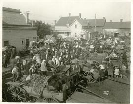
The North End market behind Dufferin Avenue and Derby Street
Carts of goods and shoppers in a bustling market around Dufferin Avenue and Derby Street in the North End.

Photograph album of Winnipeg during WW1: Page 5
Item consists of a scrapbook page showing soldiers lined up in military parade in front of the Industrial Bureau Exposition Building (Item 21), soldiers lined up in military parade (Item 22),
soldiers on horse in military parade in front of the Industrial Bureau Exposition Building (Item 23), crowd forming on street in front of the Israelite Jewish Daily newspaper building (975 Main Street) and the H. Lindster's Bakery (971 Main Street). Soldiers and Police in foreground (Item 24), [ca. 1913].
Scrapbook [1950 flood photographs]
Part of City of Winnipeg (1874-1971)
Subseries consists of a scrapbook assembled by the City Engineering Department to serve as photographic evidence of the 1950 flood. It contains black and white photographs that mostly document flooding in residential areas near the Red River (Fort Rouge, Riverview, North End, Point Douglas, Crescentwood, Armstrong's Point and others). Scrapbook appears to be organized geographically by area and street. In addition to documenting flooding, the photographs provide a detailed record of residential neighbourhoods, houses, streets, and businesses like corner grocery stores and laundries. All photographs were taken by Harold K. White Studio.
Winnipeg (Man.). City Engineer
41-1/2, 43, 45 and 47 Inkster Boulevard
Part of City of Winnipeg (1874-1971)
A photograph taken during the 1950 flood, showing 41-1/2 Inkster Boulevard and 43 Inkster Boulevard and 45 Inkster Boulevard and 47 Inkster Boulevard. Item is 4 of 8 photographs on page 32 of scrapbook.
Harold K. White Studio
47, 51, 53 and 55 Inkster Boulevard
Part of City of Winnipeg (1874-1971)
A photograph taken during the 1950 flood, showing 47 Inkster Boulevard and 51 Inkster Boulevard and 53 Inkster Boulevard and 55 Inkster Boulevard. Item is 5 of 8 photographs on page 32 of scrapbook.
Harold K. White Studio
15, 21 and 23 Inkster Boulevard
Part of City of Winnipeg (1874-1971)
A photograph taken during the 1950 flood, showing 15 Inkster Boulevard and 21 Inkster Boulevard and 23 Inkster Boulevard. Item is 4 of 8 photographs on page 32 of scrapbook.
Harold K. White Studio
33, 35, 39 and 41 Inkster Boulevard
Part of City of Winnipeg (1874-1971)
A photograph taken during the 1950 flood, showing 33 Inkster Boulevard and 35 Inkster Boulevard and 39 Inkster Boulevard and 41 Inkster Boulevard. Item is 3 of 8 photographs on page 32 of scrapbook.
Harold K. White Studio
59, 61, 63, 65 and 67 Inkster Boulevard
Part of City of Winnipeg (1874-1971)
A photograph taken during the 1950 flood, showing 59 Inkster Boulevard and 61 Inkster Boulevard and 63 Inkster Boulevard and 65 Inkster Boulevard and 67 Inkster Boulevard. Item is 7 of 8 photographs on page 32 of scrapbook.
Harold K. White Studio
83, 85 and 87 Inkster Boulevard
Part of City of Winnipeg (1874-1971)
A photograph taken during the 1950 flood, showing 83 Inkster Boulevard and 85 Inkster Boulevard and 87 Inkster Boulevard. Item is 2 of 5 photographs on page 33 of scrapbook.
Harold K. White Studio