
- p00276
- Part
- Aug. 1922
Part of City of Winnipeg (1874-1971)
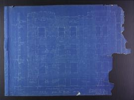
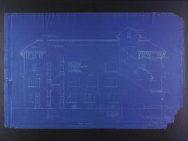
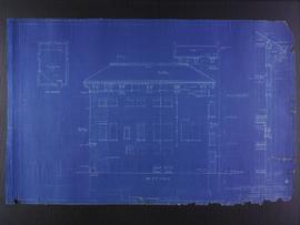
Blueprint plans of Kennedy street elevation of the Medical Arts Building at the corner of Graham Avenue and Kennedy Street. Designed by John D. Atchison. Drawing 4 of 6.
Atchison, John D.
Part of City of Winnipeg (1874-1971)
Blueprint plans of Kennedy street elevation of the Medical Arts Building at the corner of Graham Avenue and Kennedy Street. Designed by John D. Atchison. Drawing 4 of 6.
Atchison, John D.
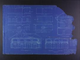
Miscellaneous elevation plans for the Club Building for the Columbus Hall Association
Part of City of Winnipeg (1874-1971)
Blueprint plans of miscellaneous elevations of the Club Building for the Columbus Hall Association Ltd. on the southwest corner of Graham Avenue and Smith Street. Designed by John D. Atchison. Drawing 10 of 11.
Atchison, John D.
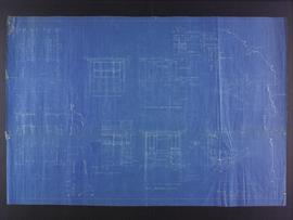
Miscellaneous plans for Medical Arts Building at the corner of Graham Avenue and Kennedy Street
Part of City of Winnipeg (1874-1971)
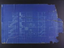
Miscellaneous blueprint plans of the Medical Arts Building at the corner of Graham Avenue and Kennedy Street. Designed by John D. Atchison. Drawing 5 of 6.
Atchison, John D.
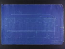
North elevation plans for the Club Building for the Columbus Hall Association
Part of City of Winnipeg (1874-1971)
Blueprint plans of north elevation of the Club Building for the Columbus Hall Association Ltd. on the southwest corner of Graham Avenue and Smith Street. Designed by John D. Atchison. Drawing 7 of 11.
Atchison, John D.
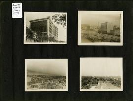
Photograph album of Winnipeg during WW1: Page 3
Item consists of a scrapbook page showing the Young Men's Christian Association (YMCA) Building at 301 Vaughan Street (Item 13); view of Portage Avenue with Eaton's and Boyd buildings in foreground and Hotel Fort Garry in the background (Item 14); view of Ashford's Bakery at Portage Avenue and Furby Street, facing south towards Broadway (Item 15); Vaughan Street facing north towards St. Paul's College on Ellice Avenue (Item 16). Dates of photographs are approximate, [ca. 1913].
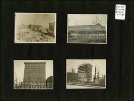
Photograph album of Winnipeg during WW1: Page 4
Item consists of a scrapbook page showing the Eaton's and Boyd Buildings (Item 17), unidentified building (Item 18),
Royal Bank Building and Leland Hotel (Item 19), Construction of Confederation Building with Volunteer Monument in foreground (Item 20). Dates of photographs are approximate, [ca. 1913].

Photograph album of Winnipeg during WW1: Page 5
Item consists of a scrapbook page showing soldiers lined up in military parade in front of the Industrial Bureau Exposition Building (Item 21), soldiers lined up in military parade (Item 22),
soldiers on horse in military parade in front of the Industrial Bureau Exposition Building (Item 23), crowd forming on street in front of the Israelite Jewish Daily newspaper building (975 Main Street) and the H. Lindster's Bakery (971 Main Street). Soldiers and Police in foreground (Item 24), [ca. 1913].

Photograph album of Winnipeg during WW1: Page 6
Item consists of a scrapbook page showing soldiers marching in military parade on street in front of the Elliott and Hazel Grocers, 975 Main Street and the H. Lindster's Bakery, 971 Main Street (Item 25), soldiers lined up in military parade (Item 26),
soldiers marching in military parade (Item 27), soldiers marching in military parade (Item 28), [ca. 1913].

Roof plans for 383-389 Portage Avenue and 290 Edmonton Street (The Edmonton Block)
Part of City of Winnipeg (1874-1971)
Blueprint plans of roof of 383-389 Portage Avenue and 290 Edmonton Street (the Edmonton Block), designed by John. D. Atchison for W.H. Gardner. Drawing 4 of 6.
Atchison, John D.
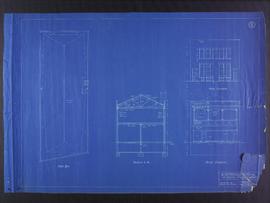
Roof, section, and elevation plans for business premises for Mr. Nation, Portage Avenue
Part of City of Winnipeg (1874-1971)
Blueprint roof plans of the business premises of Mr. Nanton on Portage Avenue. Designed by J.D. Atchison. Drawing 2 of 3.
Atchison, John D.
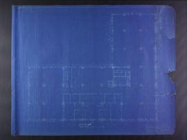
Second floor plans for 383-389 Portage Avenue and 290 Edmonton Street (The Edmonton Block)
Part of City of Winnipeg (1874-1971)
Blueprint plans of second floor of 383-389 Portage Avenue and 290 Edmonton Street (the Edmonton Block), designed by John. D. Atchison for W.H. Gardner. Drawing 3 of 6.
Atchison, John D.

Second floor plans for the Club Building for the Columbus Hall Association
Part of City of Winnipeg (1874-1971)
Blueprint plans of second floor of the Club Building for the Columbus Hall Association Ltd. on the southwest corner of Graham Avenue and Smith Street. Designed by John D. Atchison. Drawing 3 of 11.
Atchison, John D.
Part of City of Winnipeg (1874-1971)
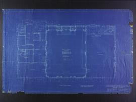
Blueprint plans of second of the Medical Arts Building at the corner of Graham Avenue and Kennedy Street. Designed by John D. Atchison. Drawing 3 of 6.
Atchison, John D.
South elevation plans for the Club Building for the Columbus Hall Association
Part of City of Winnipeg (1874-1971)
Blueprint plans of south elevation of the Club Building for the Columbus Hall Association Ltd. on the southwest corner of Graham Avenue and Smith Street. Designed by John D. Atchison. Drawing 9 of 11.
Atchison, John D.
Stair and elevator plans for the Club Building for the Columbus Hall Association
Part of City of Winnipeg (1874-1971)
Blueprint plans of stairs and elevators of the Club Building for the Columbus Hall Association Ltd. on the southwest corner of Graham Avenue and Smith Street. Designed by John D. Atchison. Drawing 11 of 11.
Atchison, John D.
Third floor plans for the Club Building for the Columbus Hall Association
Part of City of Winnipeg (1874-1971)
Blueprint plans of third floor of the Club Building for the Columbus Hall Association Ltd. on the southwest corner of Graham Avenue and Smith Street. Designed by John D. Atchison. Drawing 4 of 11.
Atchison, John D.
West elevation plans for the Club Building for the Columbus Hall Association
Part of City of Winnipeg (1874-1971)
Blueprint plans of west elevation of the Club Building for the Columbus Hall Association Ltd. on the southwest corner of Graham Avenue and Smith Street. Designed by John D. Atchison. Drawing 8 of 11.
Atchison, John D.
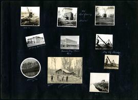
William Smaill Photo Album – Page 20
Part of William Smaill fonds
Captions read: Mile 85 - Old Fort Garry and hotel - Fort Garry apartments - Hudson's Bay stores, Winnipeg - Bay City dredge - Whitemouth, April 1914 - W.G. Chas, J.H. Fuertes [?], A. C.H. Blanchard [?] - Mile 57.
Smaill, William