
William Smaill Photo Album – Page 92
- p00210
- Part
- [1914?] - 1915
Part of William Smaill fonds
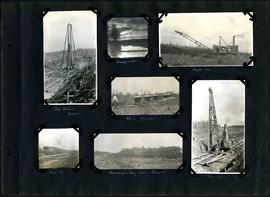
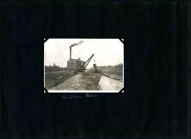
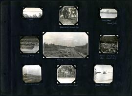
Captions read: Pile driver, mile 85 plus - Headquarter - Mile 86 - 4.5% grade - Mile 85 - Dominion Day, 1915, camp 6 - Mile 85 plus.
Smaill, William
William Smaill Photo Album – Page 92
Part of William Smaill fonds
Captions read: Pile driver, mile 85 plus - Headquarter - Mile 86 - 4.5% grade - Mile 85 - Dominion Day, 1915, camp 6 - Mile 85 plus.
Smaill, William

William Smaill Photo Album – Page 98
Part of William Smaill fonds
Captions read: Whitemouth River crossing.
Smaill, William
William Smaill Photo Album – Page 100
Part of William Smaill fonds
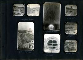
Captions read: Overflow section - Whitemouth syphon - Manhole form at sump well -Reinforcement in overflow - Bulkhead form for syphon - Overflow sump forms - Transition section.
Smaill, William
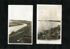
William Smaill Photo Album – Page 101
Part of William Smaill fonds
Captions read: Boat house, west bank - excavation for overflow and sump.
Smaill, William
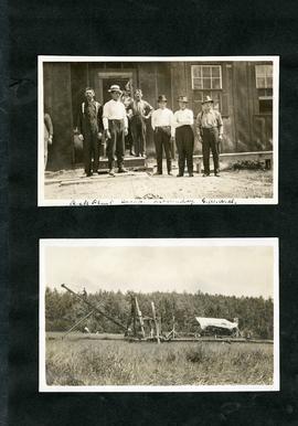
William Smaill Photo Album – Page 103
Part of William Smaill fonds
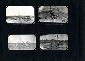
Captions read: Inverts on foundation fill, mile 71 - Trench in hardpan after rain - excavating hardpan by hand, mile 71.
Smaill, William
William Smaill Photo Album – Page 105
Part of William Smaill fonds
Captions read: Backfilling, mile 65.
Smaill, William
William Smaill Photo Album – Page 106
Part of William Smaill fonds
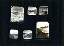
Captions read: Dyke - Blanchard's, Indian Bay - Indian Camp, Shoal Lake [Kekekoziibii Shoal Lake 40 First Nation] - Removing arch - Camp 5, mile 77 - Remains after oil House fire, camp 5, mile 77 - Excursion train, camp 6 -Tennis court, Indian Bay - Young wild ducks.
Smaill, William

William Smaill Photo Album – Page 118
Part of William Smaill fonds
Captions read: Blank Page.
Smaill, William

William Smaill Photo Album – loose page
Part of William Smaill fonds
Captions read: Bunk houses, rock plant, Greater Winnipeg Water District - Rock crushing plant, Greater Winnipeg Water District.
Smaill, William
William Smaill Photo Album – loose page
Part of William Smaill fonds
Captions read: Completed aqueduct tube, Greater Winnipeg Water District - View of Shoal Lake, Greater Winnipeg Water District.
Smaill, William
William Smaill Photo Album – loose page
Part of William Smaill fonds
Captions read: Rock plant camp, on a Sunday, Greater Winnipeg Water District.
Smaill, William

William Smaill Photo Album – Page 6
Part of William Smaill fonds
Captions read: Meeting of the rails between Winnipeg and Shoal Lake - December 1914.
Smaill, William

William Smaill Photo Album – Page 15
Part of William Smaill fonds
Captions read: Anderson's dredge making cut between Indian Bay and Snowshoe Bay.
Smaill, William

William Smaill Photo Album – Page 17
Part of William Smaill fonds
Captions read: First bucket on aqueduct - Erection number 3 class 7 at mile 64.
Smaill, William

William Smaill Photo Album – Page 18
Part of William Smaill fonds
Captions read: Class 9 at Oguaka, Iowa - Monighan machine.
Smaill, William

William Smaill Photo Album – Page 19
Part of William Smaill fonds
Captions read: Tomlison and Pleming's camp - Ballast trains - Birch River - Clearing land, Whtiemouth - Class 14 pads - Lidgerwood - Unloading boom - Camp 5, April 14 - Work train - McLerie's - Deacon - Hand cars - Culverts, mile 57 - Hunter and Jack Cumm
Smaill, William
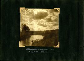
William Smaill Photo Album – Page 21
Part of William Smaill fonds
Captions read: Whitemouth River at headquarters looking east from foot bridge, mile 64.
Smaill, William
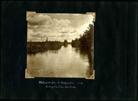
William Smaill Photo Album – Page 23
Part of William Smaill fonds
Captions read: Whitemouth River at headquarters looking west from foot bridge, Mile 64.
Smaill, William

William Smaill Photo Album – Page 24
Part of William Smaill fonds
Captions read: First foundation fill, mile 71.
Smaill, William
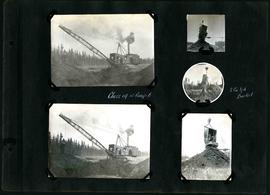
William Smaill Photo Album – Page 26
Part of William Smaill fonds
Captions read: Class 14 at camp 6 - 2 cubic yard bucket.
Smaill, William