
- d00908
- File
- 1967-[ca. 1970]
Photographs of the opening of the Nairn Overpass and green space near it.
351 results with digital objects Show results with digital objects
Photographs of the opening of the Nairn Overpass and green space near it.
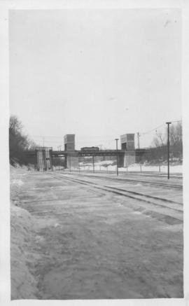
Photographs of the Nairn Overpass, including its construction and dedication.
Metropolitan Corporation of Greater Winnipeg (Man.). Information Officer
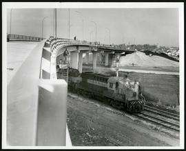
Nairn Overpass approaching completion
Photograph of the Nairn Overpass as it nears completion, looking west, as a train passes underneath.
Metropolitan Corporation of Greater Winnipeg (Man.). Information Officer
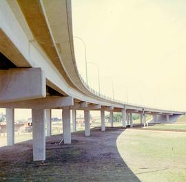
A colour photograph of the Nairn Overpass from below.
Metropolitan Corporation of Greater Winnipeg (Man.). Information Officer

Natural Cycle Courier promotional video
Part of The W.R.E.N.C.H. Winnipeg Cycling Archive collection
Part of The W.R.E.N.C.H. Winnipeg Cycling Archive collection

No. 8 A portion of the Lyndale dike in Norwood with the Norwood Bridge in the background
Photograph shows scene from 1950 flood. Description (on verso): Note the roof of the Greater Winnipeg Sanitary District Marion Street pumping station on the right. Stamp (on verso): City of Winnipeg - Engineering Dept., Water Works Division, Ross and Tecumseh.

Northdale Shopping Centre panorama
View of Northdale Shopping Centre, 963 Henderson Highway, 7.65 acres. From left to right: Loblaws Groceteria, Zeller's County Fair, various shops, the Royal Bank, the Canadian Imperial Bank of Commerce, A & P Food Store, Lord Wolseley School. Consists of 3 separate photographs pasted together on cardboard to create a panorama. The cardboard is a scrap made from an old sign of the Metropolitan Corporation of Greater Winnipeg (visible on the reverse). The cardboard is numbered “1”, presumably as part of a compilation with other shopping centre panoramas.
Metropolitan Corporation of Greater Winnipeg (Man.). Planning Division

Northgate Shopping Centre panorama
View of Northgate Plaza Shopping Centre, 1375-1425 McPhillips Street, 15 acres. From left to right: Clarks Discount Store, Various Shops, Northgate Bowling Lanes, Loblaw's. Consists of 3 separate photographs pasted together on cardboard to create a panorama. The cardboard is a scrap made from an old sign of the Metropolitan Corporation of Greater Winnipeg (visible on the reverse). The cardboard is numbered “14”, presumably as part of a compilation with other shopping centre panoramas.
Metropolitan Corporation of Greater Winnipeg (Man.). Planning Division
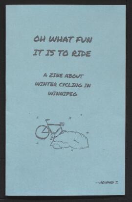
Oh What Fun it is to Ride winter cycling zine
Part of The W.R.E.N.C.H. Winnipeg Cycling Archive collection

Photograph shows old St. James Bridge approach, looking north up Madison Street (now Century Street/Route 90). Present Viscount Gort site in center. Date of photograph is uncertain, [after 1932].

Photograph shows old St. James Bridge approach, looking North up present Kintrye Street. Viscount Gort site centre right/Hydro sub-station - St. James Street and Portage Avenue far left. Date of photograph is uncertain [after 1932].
Osborne bridge - toboggan slide, Winnipeg, Winter 1918
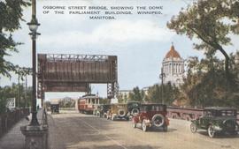
Osborne Street Bridge, showing the Dome of the Parliament Buildings, Winnipeg, Manitoba
Item consists of a postcard in printed format that shows the Osborne Street Bridge and the Manitoba Legislative Building. Motor vehicles and trolley shown crossing the bridge. Published by Valentine Edy Company, Limited, Winnipeg, Manitoba. Printed in Great Britain. Date of postcard is unknown.
Photographs of overpasses and areas of the Greater Winnipeg Area for which overpasses were proposed.
Metropolitan Corporation of Greater Winnipeg (Man.). Information Officer
Part of The W.R.E.N.C.H. Winnipeg Cycling Archive collection
Part of The W.R.E.N.C.H. Winnipeg Cycling Archive collection
Pamphlets from various cycling organizations including Bike to the Future, Critical Mass, and The W.R.E.N.C.H.

Part of East Ward, St. Boniface in the distance
Part of City of Winnipeg (1874-1971)
Photograph taken from top of Courthouse.
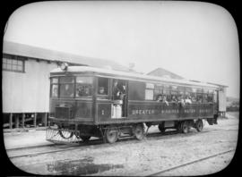
Passengers aboard GWWD Railway Service car at St. Boniface Station
Passengers aboard GWWD Railway Service car at St. Boniface Station. Image derived from glass lantern slide.
Greater Winnipeg Water District