
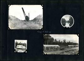
William Smaill Photo Album – Page 1
- p00119
- Part
- [1914 or 1915]
Part of William Smaill fonds
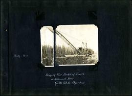
Captions read: Cloudy and sleet - Digging first bucket of earth at Whitemouth River, Greater Winnipeg Water District aqueduct.
Smaill, William
William Smaill Photo Album – Page 1
Part of William Smaill fonds
Captions read: Cloudy and sleet - Digging first bucket of earth at Whitemouth River, Greater Winnipeg Water District aqueduct.
Smaill, William
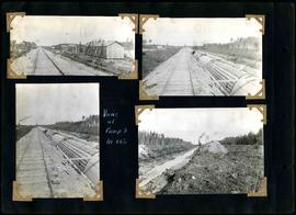
William Smaill Photo Album – Page 5
Part of William Smaill fonds
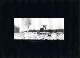
Captions read: Track layer at work.
Smaill, William

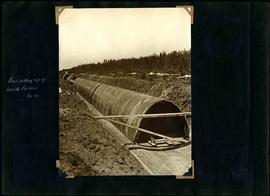
William Smaill Photo Album – Page 10
Part of William Smaill fonds
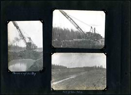
Captions read: Views at Greater Winnipeg Water District gravel pit.
Smaill, William
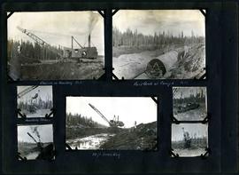
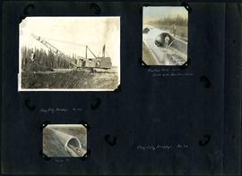
William Smaill Photo Album – Page 27
Part of William Smaill fonds
Captions read: Class 14 in 10 feet of muskeg - Raise of bottom, mile 86.
Smaill, William
William Smaill Photo Album – Page 29
Part of William Smaill fonds
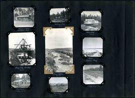
Captions read: Engineer's camp, Birch River, mile 77 - Sailman's camp, mile 88 - Hospital, mile 77 - Bay City dredge, mile 89 - Pilot ditch, mile 89 - Dyke, Indian Bay - Engineer's camp, mile 88 - Tremblays camp 1 - Mile 85.5, '16.
Smaill, William

William Smaill Photo Album – Page 34
Part of William Smaill fonds
Smaill, William
William Smaill Photo Album – Page 39
Part of William Smaill fonds
Captions read: First setting up of inside forms, mile 51.
Smaill, William
William Smaill Photo Album – Page 41
Part of William Smaill fonds
Captions read: Views at camp 3, mile 64.5.
Smaill, William
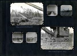
William Smaill Photo Album – Page 42
Part of William Smaill fonds
Captions read: Shows method of handling pads - shows method of support, class 7.
Smaill, William
William Smaill Photo Album – Page 59
Part of William Smaill fonds
Captions read: Class 14 in muskeg, Mile 85 - First arch at camp 6, mile 85 - Handling Stumps - 10 foot muskeg.
Smaill, William
William Smaill Photo Album – Page 60
Part of William Smaill fonds
Captions read: Camp 5, mile 77.
Smaill, William
William Smaill Photo Album – Page 64
Part of William Smaill fonds
Captions read: Camp 1, mile 51 1/2.
Smaill, William
William Smaill Photo Album – Page 66
Part of William Smaill fonds
Captions read: Camp 4, Mile 71 - Incinerator - First foundation fill placed underwater, notice water still on sides - Hauling foundation fill up 4.5 % grade.
Smaill, William
William Smaill Photo Album – Page 73
Part of William Smaill fonds
Smaill, William
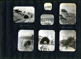
William Smaill Photo Album – Page 83
Part of William Smaill fonds
1 photograph appears to be missing. Captions read: Bay City dredge, mile 91 - Cracked arch, mile 85, broke with traveler sacks - Mile 58 - Bay City dredge, Mile 91.
Smaill, William
William Smaill Photo Album – Page 96
Part of William Smaill fonds
Captions read: Arch, mile 65 - Harold, Monty - Invert, mile 65.
Smaill, William

William Smaill Photo Album – loose page
Part of William Smaill fonds
Captions read: Water tank, Indian Bay, Greater Winnipeg Water District.
Smaill, William

William Smaill Photo Album – Page 32
Part of William Smaill fonds
Captions read: Concrete mixers, mile 77.
Smaill, William

William Smaill Photo Album – Page 36
Part of William Smaill fonds
Captions read: Culvert, mile 77 - In muskeg, mile 58 - Ditch after heavy rain, mile 57 - Muskeg, mile 58 - Shaping bottom for inverts camp, mile 57.5.
Smaill, William

William Smaill Photo Album – Page 37
Part of William Smaill fonds
Captions read: Blaw Forms - Camp 2, Mile 57, Rear View - 8 foot clear muskeg - Camp 2, front view.
Smaill, William